FortyMileDesert
Adventurer
Land Rover Trek Number 129
25 October 2008 – From North Island to Saint Anthony Mines
After a quick shower I made a pot of coffee, had a bit of cereal, packed some sandwiches, tossed the trail gear into the back of the truck, dropped the downloaded topos on the front seat, plugged in the GPS and headed for the gas station to top up. At a bit before 9:00 I’m on Interstate 80 headed east in the direction of Lovelock, Nevada.
It’s a beautiful morning. Its about 42 degrees, after a night of 30, the sun is shining, it’s very dry and there is just a hint of a breeze. After about a month and a half of not taking the Discovery off-road; she’s itching to go. You may recall that my last outing was as a passenger in Ben’s Montero Sport and a workout digging it out of a sand trap with shovels.
Passing the Hot Springs at Bradys; the steam is visible in the crisp air.
About 29 miles down the highway and the turn off to Jessup. A quick shift into low range and I head north passing the gravel quarries and up the wash about two and a half miles. Eventually I take the turn into the sneaky little side wash and cross about a quarter mile of sand to the climb up to the pleistocene beach flat on basaltic “North Island”. I’ve brought you this way before. The Disco is purring.
The climb up only makes the 4ETC “chirp” once in the loose stuff nearing the top. This is the pleistocene Lake Lahontan “high-stand”. 12,070 years ago, Lake Lahontan stood at this elevation of 4399 feet above sea level. The UNR geologists call this basalt butte North Island. This was a near shore island in the Jessup Embayment in that now long gone lake. From here on we will be exploring some new country.
I drive around the southern tip of the “island” and then turn north passing over a saddle and down a ravine on to a sand and gravel flat that was once a strait between the island and the mainland. Intersecting a trail that is on my map, I head due east towards a high tension power line service road about two miles away.
The east running trail passes across the corner of a small playa before dropping down a canyon that drains the playa in very wet winters. Just before I arrive at the pole line road I come across a sandy wash that goes north towards the 5000 foot ridgeline. As there are some quad tracks in the sand, I decide to see how far I can get.
Heading up the wash the quad track soon fade and I’m left with just following, at each fork, whichever branch of the wash seems to be the primary one. The going is moderate; in places I’m on bare flat sand, at other spots I’m threading through rocks, gravel and sagebrush. After about a mile I decide that that was fun and it’s time to turn around. Ben and Brendan will be with me on Thanksgiving; perhaps that will be a good time to see if we can get to the narrow canyon up another mile or so. It’s a piece of cake following my own tire tracks back down to the trail.
This trail intersects the pole line road in another half mile. About a quarter mile along the road and I reach an old washout. The road skirts about 100 yards up stream from the poles and crosses the wash. I stop and look over the washout. I think I’d like to try crossing that when the other two vehicles are with me next month.
The road is reasonably straight for the next mile or so following the poles. It’s mostly easy going over sand and small rocks. Then the road disappears again and I find that it turns back on itself for a bit and drops down a steep bank and then continues on in the original direction. I’ve passed a few other interesting ravines and washes crossing the road. Next month?
The road becomes a rocky shelf as it rounds the tip of a steep ridge and then crosses the face of a broad “bay”. A couple of large washes that look as if they might be fun to explore are crossed. Just prior to reaching Saint Anthony Canyon I come across a challenging little climb with an alternate go around. Its fun. When I bring Brendan here next month he may feel confident enough to try it. His Chevy pickup is stock and he’s not an off-road aficionado yet.
I reach Saint Anthony Canyon at about 12:15 and decide to head upstream looking for a “4wd” trail that supposedly goes to a couple of mine shafts and prospects. For the next half hour I take several washes to the west of the main canyon. This is very deep sandy country. I never do find the shafts but eventually I do find a trace of the trail where it had crossed a hard packed gravel area. I turn around and go back down the main canyon to the mines that I know of to the south-east.
I spend about a half hour exploring around the mines and the ore chute. I’ve been here a couple of years ago. This was a tungsten mine during the World War I and II years. A couple of the 45 degree sloped stopes have caved in a bit more. There is also a lot less ore car track left.
I leave the mines and drive down the canyon to where the road arrives at the highway. There is no highway access here. I can either take the road north-east along the shore of the Humboldt Sink to the Toulon interchange or take a south-westerly pole-line road back to the Trinity interchange where highway 95 intersects I-80. Having never taken the pole-line road; I elect that.
The pole line road is very rocky and also has to cross several very step ravines. The rocks make the going quite slow but more interesting. A couple of the ravines require making sharp jogs away from the pole line to cross them. Along the way I encounter four pickup trucks parked by chukar hunters. That surprised me as I usually see most chukars up in the canyons rather than down near the flats next to the sinks.
I get back on pavement at the Trinity interchange. Its about 35 miles back to Fernley. This trek has taken about six hours. I’ve covered almost eighty miles from Fernley to Fernley; of which almost exactly twenty miles were off-pavement.
And a few of the forty some pictures:
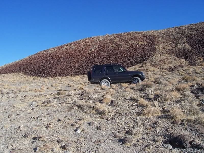
On the "beach" North Island
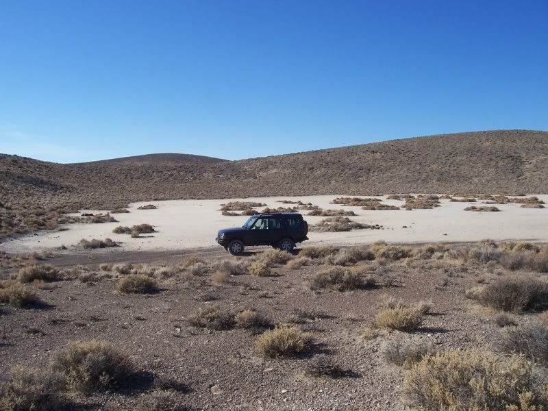
The small playa
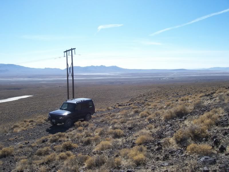
Humboldt Sink in distance
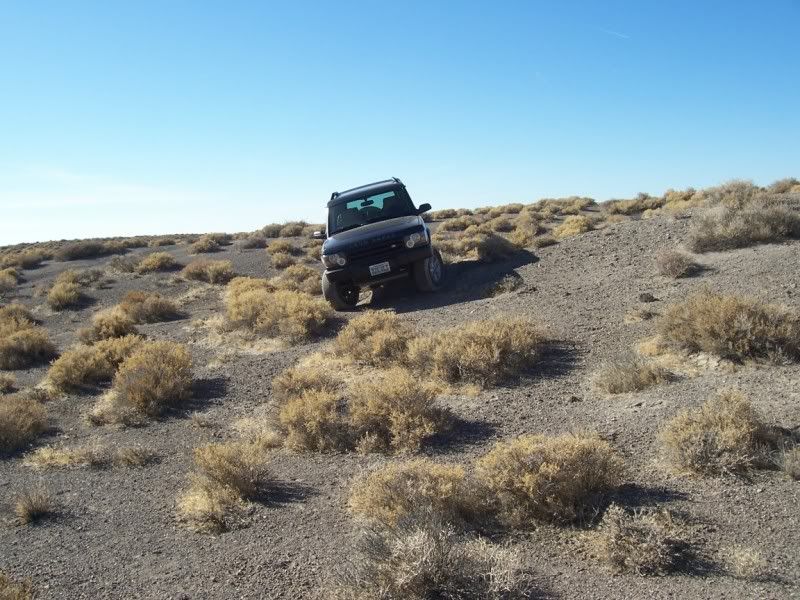
Turn around in the wash

Leaving the wash - lava capped butte
Humboldt Sink
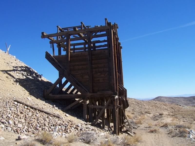
Ore chute at Saint Anthony
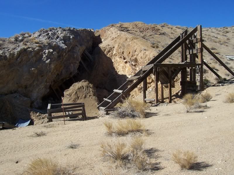
Head frame above 45 degree winze
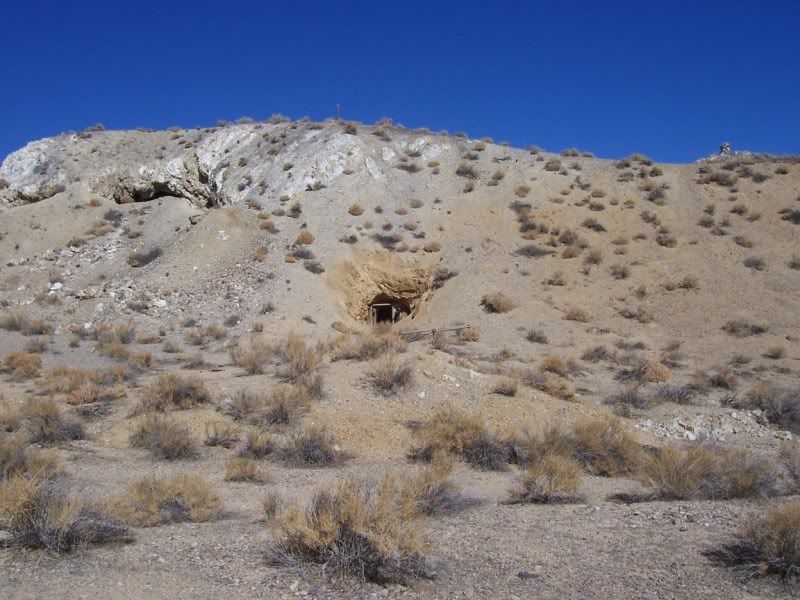
Tunnels into the cliff
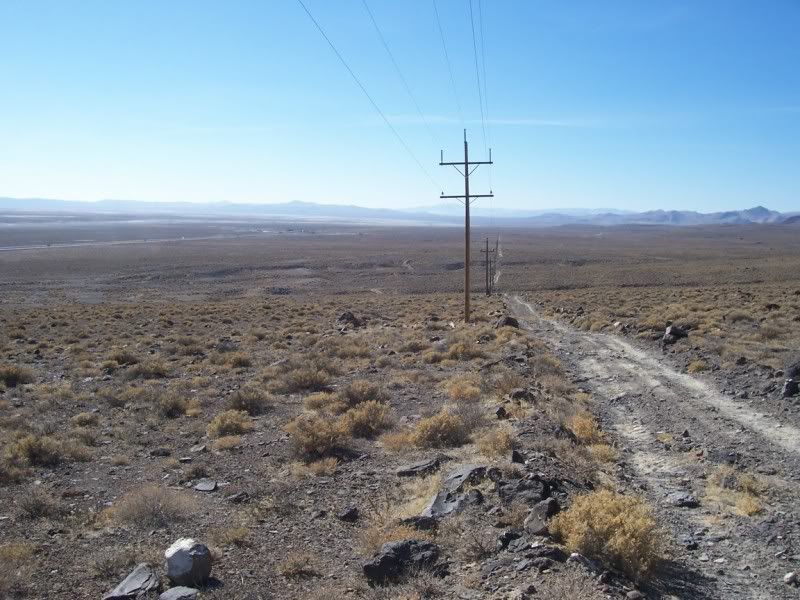
Returning along the small pole line road
25 October 2008 – From North Island to Saint Anthony Mines
After a quick shower I made a pot of coffee, had a bit of cereal, packed some sandwiches, tossed the trail gear into the back of the truck, dropped the downloaded topos on the front seat, plugged in the GPS and headed for the gas station to top up. At a bit before 9:00 I’m on Interstate 80 headed east in the direction of Lovelock, Nevada.
It’s a beautiful morning. Its about 42 degrees, after a night of 30, the sun is shining, it’s very dry and there is just a hint of a breeze. After about a month and a half of not taking the Discovery off-road; she’s itching to go. You may recall that my last outing was as a passenger in Ben’s Montero Sport and a workout digging it out of a sand trap with shovels.
Passing the Hot Springs at Bradys; the steam is visible in the crisp air.
About 29 miles down the highway and the turn off to Jessup. A quick shift into low range and I head north passing the gravel quarries and up the wash about two and a half miles. Eventually I take the turn into the sneaky little side wash and cross about a quarter mile of sand to the climb up to the pleistocene beach flat on basaltic “North Island”. I’ve brought you this way before. The Disco is purring.
The climb up only makes the 4ETC “chirp” once in the loose stuff nearing the top. This is the pleistocene Lake Lahontan “high-stand”. 12,070 years ago, Lake Lahontan stood at this elevation of 4399 feet above sea level. The UNR geologists call this basalt butte North Island. This was a near shore island in the Jessup Embayment in that now long gone lake. From here on we will be exploring some new country.
I drive around the southern tip of the “island” and then turn north passing over a saddle and down a ravine on to a sand and gravel flat that was once a strait between the island and the mainland. Intersecting a trail that is on my map, I head due east towards a high tension power line service road about two miles away.
The east running trail passes across the corner of a small playa before dropping down a canyon that drains the playa in very wet winters. Just before I arrive at the pole line road I come across a sandy wash that goes north towards the 5000 foot ridgeline. As there are some quad tracks in the sand, I decide to see how far I can get.
Heading up the wash the quad track soon fade and I’m left with just following, at each fork, whichever branch of the wash seems to be the primary one. The going is moderate; in places I’m on bare flat sand, at other spots I’m threading through rocks, gravel and sagebrush. After about a mile I decide that that was fun and it’s time to turn around. Ben and Brendan will be with me on Thanksgiving; perhaps that will be a good time to see if we can get to the narrow canyon up another mile or so. It’s a piece of cake following my own tire tracks back down to the trail.
This trail intersects the pole line road in another half mile. About a quarter mile along the road and I reach an old washout. The road skirts about 100 yards up stream from the poles and crosses the wash. I stop and look over the washout. I think I’d like to try crossing that when the other two vehicles are with me next month.
The road is reasonably straight for the next mile or so following the poles. It’s mostly easy going over sand and small rocks. Then the road disappears again and I find that it turns back on itself for a bit and drops down a steep bank and then continues on in the original direction. I’ve passed a few other interesting ravines and washes crossing the road. Next month?
The road becomes a rocky shelf as it rounds the tip of a steep ridge and then crosses the face of a broad “bay”. A couple of large washes that look as if they might be fun to explore are crossed. Just prior to reaching Saint Anthony Canyon I come across a challenging little climb with an alternate go around. Its fun. When I bring Brendan here next month he may feel confident enough to try it. His Chevy pickup is stock and he’s not an off-road aficionado yet.
I reach Saint Anthony Canyon at about 12:15 and decide to head upstream looking for a “4wd” trail that supposedly goes to a couple of mine shafts and prospects. For the next half hour I take several washes to the west of the main canyon. This is very deep sandy country. I never do find the shafts but eventually I do find a trace of the trail where it had crossed a hard packed gravel area. I turn around and go back down the main canyon to the mines that I know of to the south-east.
I spend about a half hour exploring around the mines and the ore chute. I’ve been here a couple of years ago. This was a tungsten mine during the World War I and II years. A couple of the 45 degree sloped stopes have caved in a bit more. There is also a lot less ore car track left.
I leave the mines and drive down the canyon to where the road arrives at the highway. There is no highway access here. I can either take the road north-east along the shore of the Humboldt Sink to the Toulon interchange or take a south-westerly pole-line road back to the Trinity interchange where highway 95 intersects I-80. Having never taken the pole-line road; I elect that.
The pole line road is very rocky and also has to cross several very step ravines. The rocks make the going quite slow but more interesting. A couple of the ravines require making sharp jogs away from the pole line to cross them. Along the way I encounter four pickup trucks parked by chukar hunters. That surprised me as I usually see most chukars up in the canyons rather than down near the flats next to the sinks.
I get back on pavement at the Trinity interchange. Its about 35 miles back to Fernley. This trek has taken about six hours. I’ve covered almost eighty miles from Fernley to Fernley; of which almost exactly twenty miles were off-pavement.
And a few of the forty some pictures:
On the "beach" North Island
The small playa
Humboldt Sink in distance
Turn around in the wash
Leaving the wash - lava capped butte
Humboldt Sink
Ore chute at Saint Anthony
Head frame above 45 degree winze
Tunnels into the cliff
Returning along the small pole line road