"Lola" - WreckDiver1321's 2005 Frontier CC/SB Nismo Build and Adventure Thread

wreckdiver1321

Overlander
Just in case anyone is curious, I used Rocky Road's gear ratio calculator to figure out the optimal gearing for my truck on 285s if I were to regear. If I was going to regear to where my truck was on 265/75s (which I liked), the optimal ratio would be a 3.49. If I wanted to get crazy and have it geared to behave like it was on the 265/70s, then the optimal ratio would be a 3.60. Both scenarios are able to be accomplished by using factory gear ratios.

Nissan makes 3.54 and 3.69 gears for the R180 front diff. So if I was going to regear, the 3.54 gears would be a good place to go.

Not saying I'm planning on it, but it's nice to know I've got the option if I feel like I need to.
 

RedF

Adventurer
Hahaha yes and no. You crossed paths with Lola, but not me.

I'm currently down in Houston, getting my brother settled into his new apartment. Meanwhile, my fiancee is having a staff reunion at the youth camp she used to work at south of Big Timber. Since the road can get rough and she has a '14 Focus, she took my truck down there and picked up some other people in the process. I am told everyone was green with envy :D

Well, at any rate thanks for the tip on that trail. Fun, pretty mild with a few challenging spots. Lots of natural beauty. We got up to "Y" in the road after the creek on Independence trail, then turned around. The misses had enough, and we were starting to get low on fuel.

The road in and out of that place is almost worse than the trail!
 

wreckdiver1321

Overlander
Well, at any rate thanks for the tip on that trail. Fun, pretty mild with a few challenging spots. Lots of natural beauty. We got up to "Y" in the road after the creek on Independence trail, then turned around. The misses had enough, and we were starting to get low on fuel.

The road in and out of that place is almost worse than the trail!

No worries man, glad you enjoyed it!

Sounds like you made it about 1/3 of the way in. Too bad, the top of that trail is amazing. But at least you got to see it! I'll be running that trail on the 10th and climbing the mountain, Monument Peak, that's at the top. Should be a fun trip.

Hahaha funny you say that. That road was graded last summer. :D

That very last camp on the road is where my bride to be worked. Cool spots out there eh?
 

jhberria

Adventurer
Hey man, haven't commented on the 33s yet......so I am now. They look great! Have you gotten off highway yet with the new rubber?
 

wreckdiver1321

Overlander
Hey man, haven't commented on the 33s yet......so I am now. They look great! Have you gotten off highway yet with the new rubber?

Thanks man! I'm loving the look and the function. Should have just waited and gotten 33s in the first place.

Off highway, they rock. At 25 psi they feel like my 265s at 18. At 20 psi they are buttery smooth. Soak up all the bumps and just ride like a dream. The traction is fantastic too. They just grip and grip and grip, but I knew that already. The extra width is kind of nice too. Not sure how to describe it, but they just feel more planted.

Best part about them? I hand calculated my mileage on a trip the last couple days. I made sure to calculate the extra diameter of the bigger tires. On the 265s I was getting 18.5 mpg. With my new 285s, I'm just about dead on at 18 mpg. So the bigger shoes only cost me .5 mpg!

Been a while since I have been on here but I'm liking the new fridge addition!

Hey man, nice to see you around here again. Thanks, I'm loving the fridge! It's a sweet little addition.
 

RedF

Adventurer
If you ever have a chance, I'd love to see pics of the top of independence - see what we missed out on.
 

wreckdiver1321

Overlander
Beartooth Highway, August 2015

So my friends and I get antsy when we're doing mods.

My good friend Sandragoon here on the forums and I just got finished trimming the inner fenders of his Subaru Baja for his new, bigger AT tires, and we decided we needed to go test them out. So we headed up the Beartooth Pass to the south to find some rough terrain to travel over. We found a cool spot for lunch.


On the way out, I decided to do some flex testing!


As you can see, I finally managed to get my skidplate on there :D More on that later...


Stuffs pretty nicely I think.

We ended up running some minor trails and finishing off the highway into Cooke City. We had planned to check out a trail north of town, but the weather moved in fast, bringing heavy rains and a lot of hail. Being caught out in a thunderstorm near the tops of mountains seemed like a daft idea to us, so we decided to call it a day and headed back down. Luckily, the views were awesome.


Once we were back home, we laid out the final plans for our trip into the Boulder River Valley. This would be a much rougher trip, but so much more rewarding.
 

wreckdiver1321

Overlander
Independence Mine Trail and Monument Peak, August 2015

So the Independence Mine trail south of Big Timber has been at the top of my "must drive" list for quite a long time, but I've never had the opportunity to explore it to it's end until now. I knew Lola could handle it, I knew there would be little to no snow, and I knew I wanted to get there. My fiancee had told me that the top of the trail was pretty spectacular, and the videos and photos I had seen of it backed that up. Then I saw the very first Expedition Overland episode, and saw that they did the trail. So I just had to do it.

My friend with the Baja wanted to see if he could make it as well, so we hit the road on Monday, bound for Big Timber. The drive was uneventful, and when I got there and fueled back up, I hand-calculated my mileage to be 18.05 mpg. That was pretty cool, seeing as how my 265s only got 18.5. That means I dropped a whopping 0.45 mpg with the larger and heavier 285s. From the gas station in Big Timber, we headed south until we were engulfed by the mountains. After about 30 miles, the tarmac ends. Then it's a rough and potholed dirt road for a further 20 miles or so. At the end of the dirt road, Independence Trail sits rather nondescript at the opposite end of a parking lot. Almost immediately, the trail is fantastic. Lots of water to cross, large rocky steps, and loose scree make the trail really fun. It's not really a challenging trail so much, but it is really fun. There are a couple challenging obstacles though.


The trail winds it's way up the sides of the Boulder River Valley to the old mining town of Independence. This town boomed from 1888 until 1893, when gold, copper, silver, and lead were discovered in the surrounding mountains. As such, there are old mining town ruins all over the area. Sadly, we were chasing the sun on both the trip up and down the trail, so we didn't get an opportunity to stop and explore the ruins this time. Guess we'll have to wait until next time :)

Sandragoon's little Baja was performing like a champ. It crawled up and over the obstacles pretty well, although there were times when the transmission got hotter than we would have liked. Otherwise, it was handling it beautifully. When we got about halfway up the trail, we noted the fuel level of his car and the time. His car was sitting right around 1/2 a tank, with Lola being slightly over 3/4 full. That's a problem. The other problem was time. At that point, it was 5 PM, and his car had to take the obstacles slower than I did. After a brief chat, we decided to leave the car parked near an abandoned cabin and finish the trail off with Lola.

The last two miles of trail presents you with the most challenging obstacles, including a couple spots where I needed a spotter. It really does get really rough. But Lola handled it well and we made it to the end without issue. We set up camp not far from Blue Lake and went about making dinner before turning in for the night. The fridge really proved it's worth here. I was so happy having cold but not soggy food.


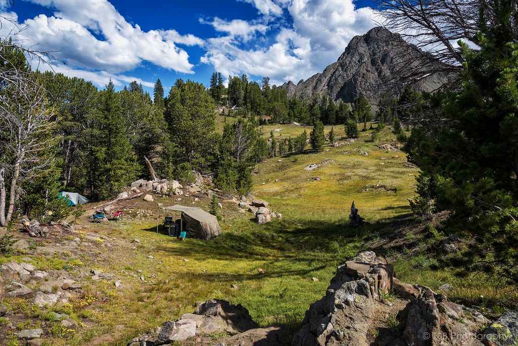
The next morning the sun danced over the granite spires of Monument Peak and Haystack Peak. It was an awesome sight to behold, and it truly humbles you. The camp we had set up was at 9400 feet, and the surrounding peaks were at a nearly incomprehensible 10,500+ feet, well above the treeline. They look like cathedrals of granite rising from the wilderness.


I started my morning off with a little tea I like to brew when I camp.


Scout was having a great time as we watched our friend Austin make a few packets of oatmeal.


So after breakfast, we started to prepare for a hike we have been talking about for some time. You see, at the end of the trail is Blue Lake. Towering above Blue Lake is the very aptly named Monument Peak. Monument is a massive 10,995 feet tall, the tallest mountain for miles. And we wanted to stand at the top.


The hike is a little daunting. From our campsite, it's about a two mile hike one way. But, in that two miles, you go from 9,400 feet to 10,995 feet, often climbing over giant boulders of granite. So it's not the easiest thing in the world. We set off at around 11 AM, and made really great time. We hit the saddle around noon, finding a stunning view of the granite tower and Blue Lake below.

If you click on this picture and zoom in on it in the Flickr viewer, you can just see my friend standing in the top right corner. That gives you an idea of the scale. It's almost impossible to comprehend when you're standing there.


From there, the climb starts to get a little more sketchy. As the grass covered ground gives way to granite blocks and scree, it becomes very narrow and unforgiving. It becomes a lot of hand-over-hand climbing. The final stretch from the saddle to the summit takes an hour. Once you get to the top though, you are met with this view.


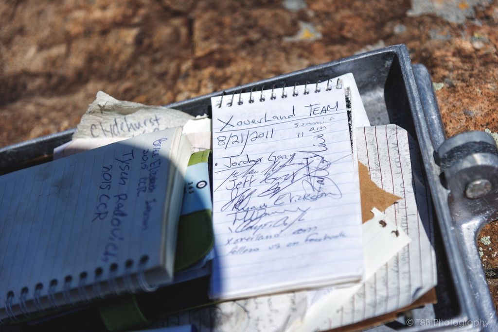
Here, standing atop this narrow pile of rocks scraping 11,000 feet in the sky, you really get a sense of how small you are and how big the world can be. The exhilaration of being at the summit floods in and you are just in awe. I'm fairly sure this is what the gates to heaven look like. The other thing you notice at the top is a piece of rebar stuck in the rocks at the highest point. About 10 feet away is a small metal box with the Forest Service insignia stamped into it. Open the box, and you'll find notebooks full of the writings of the people who have climbed this imposing peak, along with a few mementos. We wrote our names down in a book with the title "Conquerors of Monument", and let that sink in. Although many people have done this mountain before us, it gave us a real sense of accomplishment and the feeling of being a part of an exclusive club. It was a great feeling.

Also inside the box, we found this!


After a while on the summit, which included a couple phone calls (amazingly, you get service up there!), we headed back down the mountain and into camp. My legs felt like jello for the rest of the day, but I managed to haul myself to Blue Lake and snap some photos of what we had just overcome.


After evaluating our travel deadlines, it was decided that we would head back down the trail that afternoon and find a place to camp closer to the end of the trail. That way we could get home quicker the next day, as some of us needed to go to work on Wednesday. We very tiredly packed up the camp and made our way back down the trail.

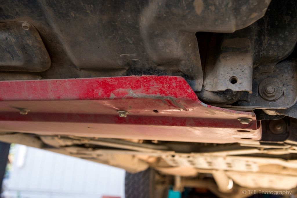
On the way back, I was very tired and my nerves were a bit shot. All I wanted to do was get down. Well, I took a water crossing a bit faster than I should have, and this happened.


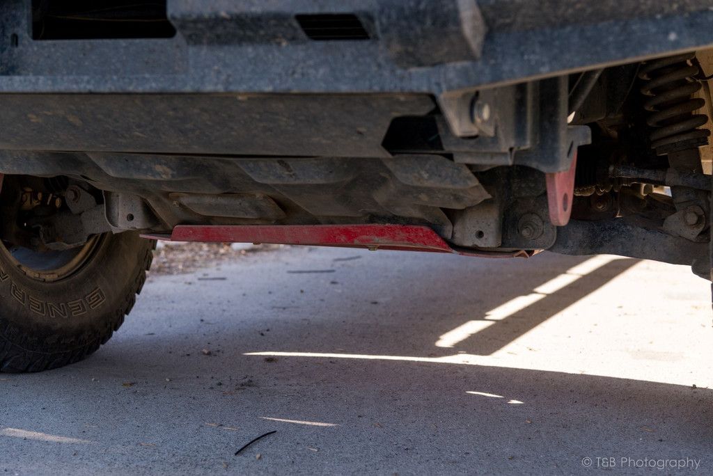
Lurking just under a pool of muddy water, a rather large rock reached out and gave my skidplate a good kicking. It's missing some paint and isn't quite straight anymore, but at least that rock didn't get to what is above that skidplate. The plate is still strong and secure, so I'm not going to worry about it much. I just need to remember to go a little slower next time :D


After that, we made it back down the trail without incident. We arrived back at the Baja, and discovered some good Samaritan had pored a quarter tank's worth of gas into the tank! Cool little surprise there. They must have seen the car and figured it was low or out of gas. After that little event, we made our way to a campsite near the start of the trail. We had another little chat and it was decided that we just felt like going home. Sandragoon was badly sunburnt, and we just didn't feel like setting up camp again. So we called it a day and drove back out of the mountains, and eventually made it home unscathed.

What a fantastic trip we had.
 

wreckdiver1321

Overlander
On Wednesday after we returned from the trip, I got a package of really cool parts in the mail.

I've been toying with navigation apps on my phone for a while now, and I found out I really like Backcountry Navigator, and I really wanted to use it on my Canada trip, as well as other trips in the future. I also use my phone as my music player and OBDII scanner, so I wanted to be able to see it when I needed to without excessive fussing. So I stole this idea from over on TacomaWorld.

I bought these:

http://www.rammount.com/part/RAM-B-201U-A

http://www.rammount.com/part/RAM-HOL-UN7BU

http://www.rammount.com/part/RAM-B-367U

I pulled out the lower bolt for my driver's side grab handle and found a longer replacement for it at Ace. Then it was a simple matter of putting it all together.


Now I have a really solid phone mount that keeps it out of the way, but within immediate vision and reach. Plus, I think it looks really nice and clean.
 

jhberria

Adventurer
Pictures all all great, brother. Looks like a fun trip. I'm going to have to join you on one of these Montana excursions eventually, or at least try and hit some of the locations you've been documenting. Might try and take a week off in the fall/winter and head out that way.

Also, to avoid digging through 84 pages of your build thread, do you have a write up on your CB antenna installation? I can wrench on a truck all day long, but me and electronics DO NOT mix. I, too, want to mount a new antenna on my bumper and am looking for ideas.
 

wreckdiver1321

Overlander
Pictures all all great, brother. Looks like a fun trip. I'm going to have to join you on one of these Montana excursions eventually, or at least try and hit some of the locations you've been documenting. Might try and take a week off in the fall/winter and head out that way.

Also, to avoid digging through 84 pages of your build thread, do you have a write up on your CB antenna installation? I can wrench on a truck all day long, but me and electronics DO NOT mix. I, too, want to mount a new antenna on my bumper and am looking for ideas.

Hey thanks man! If you can make it out here in the fall, that's just about the best time. Let me know when you head this way, I'll show you around. It's a fantastic place to explore.

I don't have much of a write up, but I can tell you what I did. I bought a 3 foot Firestik antenna, which will mount right to the existing hole in the bumper. Then I bought a cable from K40 that has a removable connector on one end. There's a factory hole with a plug in it in the firewall near the brake booster and the grommet where the wiring loom goes through the firewall. I pulled the plug out and put in a grommet. Then I ran the cable through and over to my radio. Super easy.

I'll get some links for the parts and PM them to you.
 

jhberria

Adventurer
Parts links would be great! Thanks man. I'm also digging the grab handle ram mount, might need to steal that idea for the Xterra, as well.

I'll see what I can do about taking a week in November, potentially, and trek over the Cascades to your part of the world. My brother and I are planning a trip to Montana/Wyoming/Idaho next summer in an effort to follow some of the routes from the original Expedition Overland season, so this would be a good scouting opportunity for me. Thanks!
 

RedF

Adventurer
Thanks for the write up and the pics. Quite impressive the Subaru made it as far as it did!

Would you believe that I bent my front skid plate heading back down those trails too? It folded up like a cheap tent!

Where are you heading in our great white north? When?
 

Forum statistics

Threads
188,464
Messages
2,905,356
Members
230,428
Latest member
jacob_lashell
Top