For the longest time I used to use an old handheld Garmin eTrex Legend GPS and waypoints loaded. Worked ok but w/out any kind of built in topo map, it was a rudimentary system at best.
I then upgraded to an Acer netbook with a solid state drive (for off road reliability), Nat Geo state topo software, & a sirfstar III usb gps puck which was mounted inside my rig (home made mount). Very nice and reliable setup although I'm sure the dirt and dust wasn't good for the netbook. Before it broke, I decided to replace it with something more reliable for the long term.
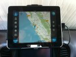
I upgraded that setup to a 16GB wifi iPad 1, Scenic Maps Western US topo maps & a Dual XGPS-150 gps unit mounted using part of my original netbook mount and a RAM locking ipad mount. The gps is sometimes flaky but with finagling (mostly disconnecting/reconnecting several times and maybe a total system shut down/restart), I've usually been able to get it to run. The scenic maps software I like because I don't have to download map quads like some of the other 'fuller featured' software solutions require. I've tried other software solutions as well but all seemed a bit cludgy and difficult to operate.
If I were to do it all over again, I'd go straight to the iPad setup w/ the scenic maps software. No questions asked. I would also immediately switch to a different bluetooth gps if I could confirm others are more reliable.
HTH.

