Overlanding Phone Apps

Overland Journal

Official Forum Sponsor
We can all agree the cell phone is here to stay, for better or worse. No longer just a tool for making the occassional call, today's phones are pocket-sized mini computers with big capabilities. The Overland Journal team put our heads together to create a short list of our favorite phone applications for overlanding. The prefered device amongst the team is the iPhone, which heavily influenced this short list, but these apps have similar products offered for other devices.


Topo Maps $7.99 iPhone

View USGS 1:24,000 topographical maps in the palm of your hand. Download up to 69,000 individual maps all tiled together for seemless viewing. Manage waypoints, measure distances, search for landmarks, and much more with this full featured app by Phil Endecot. This is the one application used by nearly all of the Overland Journal team.

topo_app.jpg


Coffee Spot Pro $1.99 iPhone

Publisher Scott Brady has coffee locating skills second to none. He may not need a fancy app to deliver him to his next mocha, but for the rest of us, this clever app may greatly improve our mornings on the go. Just enter your current location and Coffee Spot Pro serves up a list of coffee shops nearest you.

coffee.jpg


Pocket Universe $2.99 iPhone

Unless you travel with Galileo and Copernicus, this app is the perfect companion for enjoying the night sky. Taking the star chart to the next level, the Pocket Universe app allows you to simply hold your phone to the night sky and it labels the viewable stars, planets and constelations just beyond your phone. This award winning app is a team favorite.

universe.jpg


Sunrise Sunset $.99 iPhone

This useful app is a photographer's best friend when planning for that golden hour of light that makes images really pop. It's also helpful when planning your early morning departure, or late evening camp.

sunrise.jpg


Currency Exchange Pro $1.99 iPhone

Keep track of your travel budget with this easy to use app from Paolo Grifantini. This award winning app tracks current exchange rates for 220 currencies. Fast, easy to use, and always up to date, this is a great app for any overlander crossing borders.

currency.jpg


If you have a favorite phone app, we'd like to hear about it. Post your favorite overlanding phone app
 

dzzz

I wonder if Siri will tell Scott where to find coffee?

I use Dropbox to manage travel documents on multiple platforms. I don't think icloud will replace Dropbox for my use.

Camera+ is way better than the IOS 4 camera app.

Typing "sunrise" or "sunset" into google will yield the time of the event for the current day and location (if net connected).
 
Last edited:

BKCowGod

Automotive ADHD is fun!
I use the GasBuddy app heavily. It provides crowdsourced fuel prices (and gas station locations in unfamiliar towns), sorted by price or distance. What's especially great is you can search for your specific octane or fuel type so you will know if a station has Diesel. It's free and available for Android and iPhone.

If available (read: Android and WebOS easily, iPhone is more of a challenge), a tethering app is a huge benefit. I'm typing right now on my MacBook, but it's connected to the "portable hotspot" on my Android phone. Helps to have a real keyboard and a real web browser.

The Android-only Google Sky Map is a free app that does the same thing as Pocket Universe (mentioned above).
 

benedmonson

Disabled Adventurer
Great Finds for Maps on the App Store

I finally found a mapping software that I am really happy with called Scenic Map Western USA by GrangerFX. They make 5 maps covering the US that are about 2 GB's each to install on your Apple device and are for sale in the APP Store. They also have a FREE map that covers the entire USA called "You Need A Map!" :ylsmoke:
 

cnynrat

Expedition Leader
Here are a few I use regularly on my Android phone (original Moto Droid).

Backcountry Navigator - Free demo version, Pro version is $9.99 on the Android platform.

I've been using this one on our past few trips this summer. My only observation would be that it would be more useful if we ran it on a tablet for the larger screen size.

ss-480-1-24


Google Maps - Free on the Android Platform.

IMO, Still the standard for navigating to and from the dirt, so long as you are in cell coverage.

ss-480-1-12


Fuel Log - Free on the Android platform.

A useful app for tracking fuel usage and related stats.

ss-480-1-10


Google Sky Map - Free on the Android Platform.

Just a great, fun app for anyone interested in stargazing.

ss-480-0-13
 

mountainpete

Spamicus Eliminatus
Road Trip - I've used this for tracking all of my fuel usage for the past two years. http://itunes.apple.com/us/app/road-trip-mpg-mileage-fuel/id298398207?mt=8

Sky View - I have tried a few night sky apps and this one felt the easiest to use (and the cleanest interface). http://itunes.apple.com/us/app/skyview-explore-the-universe/id404990064?mt=8

WhatKnot - Columbia sportswear's app that shows how to make lots of rope knots. Great free apps - http://itunes.apple.com/us/app/skyview-explore-the-universe/id404990064?mt=8

Kayak - when you're passing through a city and you just want a hotel, this is the app to use. http://itunes.apple.com/us/app/kayak-flights-hotels-rental/id305204535?mt=8

Goodreader - the best way to keep your various PDF's on your device. Think PDF copies of services manuals, etc. http://itunes.apple.com/us/app/goodreader-for-iphone/id306277111?mt=8

TuneInRadio - If you're in wireless coverage and you have a good data plan, this is a great way to listen to BBC News, pick up a local hockey game, etc. http://itunes.apple.com/us/app/tunein-radio-pro/id319295332?mt=8
 

BKCowGod

Automotive ADHD is fun!
Dave - just a note, the newest version of Google Maps no longer requires a continuous data connection... It downloads and caches the data for your route. Still not perfect, but better than it used to be! (I loved getting/making a phone call and losing my navigation!)
 

dzzz

What's the name of the app that translates foreign language street signs viewed in camera mode?

Also, is there an app that easily attaches text to images captured by the camera? I find I use the camera more and more for documentation, but I don't what those photos just thrown into the camera roll.
 

Dendy Jarrett

Expedition Portal Admin
Staff member
I use two iPhone apps not mentioned so far:
1- Gas Cubby- to keep track of gas usage and mileage for year end taxes.
2- Smitty Bilt has a free clinometer

and for $39.95 (one time)- I downloaded Garmin Nuvi app which essentially turns your iPhone into a Garmin Nuvi with voice nav directions.

Dendy
 

cnynrat

Expedition Leader
Dave - just a note, the newest version of Google Maps no longer requires a continuous data connection... It downloads and caches the data for your route. Still not perfect, but better than it used to be! (I loved getting/making a phone call and losing my navigation!)

I think I knew that, but don't you need to make those downloads in advance based on your route?

Of course, with Backcountry Navigator you need to download the topos in advance, but one difference there is if it's an area to visit regularly the map download is a one time deal.
 

BKCowGod

Automotive ADHD is fun!
I think I knew that, but don't you need to make those downloads in advance based on your route?

Of course, with Backcountry Navigator you need to download the topos in advance, but one difference there is if it's an area to visit regularly the map download is a one time deal.

I'm not sure exactly how it works, but I do know that it downloaded all the maps for my entire route to my parents' house (which includes several sections of no cell coverage).
 

sandalscout

Adventurer
Great thread. OpenStreetMaps on Android is a proimising up and coming tool, and CraftyCoder hass expanded upon that creating a VERY cool application for motorcycle adventurers. Check out DualSportMaps for Android and DualSportMaps.com for the software ($20) and a ton of maps (free). Great site and with full integration to the site via the app, a killer combination (paired with Google Maps/Nav for free) that can do almost anything that a Garmin Montana can do.

I also like Car Music (http://www.androidcarmusic.com/) as an easy to use music player with large buttons. Makes it much easier to hit with gloves on.
 

dirkdsoesdirt

New member
Spot Connect - the newest of SPOTs satellitte tracking has an app so that even without cell coverage you can see on your iphone where you are (google maps) and send custom messages back to the loved ones.
I upgraded a couple of months ago and just love this app and the way it works with SPOT.
The iphone connects via bluetooth to the tracking device so you see the progress as well as the person back home see it. If you have to send a message, just type it in the iphone and it sends the text back through the device to your contacts at home.
App Store = Spot Connect
 

esh

Explorer
I was going to make an equivalency list for just Android, but I see we have a great start to it already-

Backcountry Navigator, check
OruxMaps, free and DIY.. equivalent to OziExplorer approach
ss-480-1-11.jpg


Google Sky Map, check


Sun Surveyor, free and $6.49 version
I use this for photography and either choosing a camp site or orienting the truck when I want early or late shade in the morning.

ss-480-1-20.jpg
ss-480-2-14.jpg


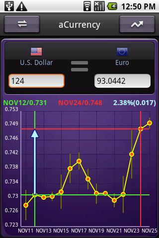
aCurrency, free and $3.49 Pro version

ss-320-3-6.jpg
ss-320-2-6.jpg


aCar, free, and $5-$15 donation Pro version

One of the best cost and maintenance schedule apps I've found. Lots of data and nerdy graphs too!

ss-480-0-5.jpg
ss-480-1-5.jpg
 
Last edited:

Forum statistics

Threads
188,153
Messages
2,902,862
Members
229,582
Latest member
JSKepler
Top