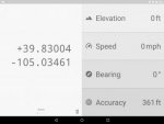
Positional: Simple GPS App w/ Coords, Elevation, Speed, Bearing

Airmapper

Inactive Member
I've noticed that GPS elevations on serveral apps are questionable, including Positional. Is this just a problem with GPS, or worse at lower elecations?

Yesterday, I was showin off the App and was at a known 18ft. It showed minus 128. It was rainy and cloudy, if that's a factor.

GPS derived elevation is not nearly as accurate as the 2D location. This is most likely a matter of the sensitivity of your phones GPS receiver how accurate it is.

GPS elevation can get pretty good if you have a good antenna, the software can obtain and use the augmentation satellites that provide correction algorithms, and so forth. Survey grade GPS and the units used in aircraft are capable of obtaining a elevation figure you can sort of trust. That said aircraft all have barometer based altimeters.

Some phones also have barometers, my Samsung S7 does. I would not know if Positional uses that, but I doubt it as barometer based altimeters require calibration, and all apps that use it will have a interface to calibrate at a known altitude.

My handheld GPS has a barometer, which tells you how confident they were in the reliability of GPS derived elevation....

Another thing to keep in mind is GPS signal is a variable thing, depending on the number of satellites above the horizon, the spread of them in the sky relative to the receiver, and solar activity, a locks accuracy can vary. For most people it's good enough most of the time, but there are odd times if all factors are working against you the accuracy can get dicey.
 

Rando

Explorer
GPS altitudes (aka 'Vertical Precision') are inherently less accurate than their horizontal measurements - and this can be magnified by compounding sources of error such as a high liquid water path (clouds). This is due to the geometry of the satellites. GPS works by calculating the distances from your point to a number of GPS satellites by measuring the time of flight for the radio waves to reach you from the satellite (called psuedoranges in GPS speak). You need at least 4 satellites to compute a 3D position - and that position is the point in space where distances from each satellite match the measured distances from the receiver. If you a range from a satellite that is due North of you, and a range from a satellite that is due South of you, you can locate your latitude more precisely because even if the ranges are both reading 100m long, your position would still be correct if you average the two measurements. Unfortunately you can never have a satellite below you, so you have no ability to improve your vertical position by using satellites on either side of you. The effect of geometry on the calculation of position is called the Dilution of Precision (DOP) and there are separate numbers for the Vertical DOP (VDOP) and horizontal DOP (HDOP). Typically VDOP is at least 50% larger than HDOP and the DOP numbers are multipliers for any intrinsic errors such as RF propagation delays from the ionosphere or from a high liquid water path.

It could also be that your GPS was still in 2D mode. With 3 satellites you can still calculate a position if you assume the altitude - what that altitude assumption is is receiver dependent.
I've noticed that GPS elevations on serveral apps are questionable, including Positional. Is this just a problem with GPS, or worse at lower elecations?

Yesterday, I was showin off the App and was at a known 18ft. It showed minus 128. It was rainy and cloudy, if that's a factor.
 

mtrewartha

Observer
I promised an update awhile ago and the holidays just consumed my time. I'm back to actively developing this again though, so there should be an update soon!

I like the white on black color scheme, easy to read,
Consider droping the minus sign on the Longitude. It is implied when refering to the W(est) direction.
Accuracy - assume this is associated with the Lat/Long positon as opposed to the elevation?
Satellites - Interesting but not very useful unless one knows the relationship between accuracy and number of satellites used in the position calculation. Consider leaving it out.
Looks good and I have used it a couple of times to check/confirm location on a paper map. Have the app on the tablet I use for digital navigation. Easy to check position as opposed to finding mobile phone, turning it on, and going from there.
Keep up the good work.
Jim H

Done! Dropped the minus sign, which also led me to fixing another bug, so thank you for pointing that out!

I really like UTM coords. I just loaded it on my samsung tab A 7" and the coords would be way better stacked and way larger. Elevation is generally secondary to just having the coords. Like others have mentioned here, I tend to use paper maps and really just need something to pick up sats fast and tell me the coords. This could be IT with a couple tweaks. I use "gps status" on my phone for this now but it has a lot of non essential info and the coords are kind of small. Thanks!

I originally built the app the show me elevation, but now that it's gaining more adoption, I'm changing up the layout to more prominently show coordinates. Just last night I started building out conversions to UTM and MGRS, so those formats will be options shortly! Also, eventually, I'll make a tablet-optimized layout for folks like you so that things look more appropriately sized and positioned. Thanks for the feedback!

Thanks for making this, and making it free of charge and advertisements.
Im not much of an app or smartphone guy, but I have asked "what's our elevation" many, many times.
This seems perfectly simple as described.
I'll install it tomorrow.
Thanks again.

No prob! Enjoy it and feel free to give me feedback. All the feedback I've gotten so far from folks has been great.

I've noticed that GPS elevations on serveral apps are questionable, including Positional. Is this just a problem with GPS, or worse at lower elecations?

Yesterday, I was showin off the App and was at a known 18ft. It showed minus 128. It was rainy and cloudy, if that's a factor.

Yeah, like Airmapper and Rando mentioned, this highly depends on the receiver and signal quality. Phones aren't known for having the most accurate receivers. That said, they're still accurate enough to be useful for the majority of use cases. Eventually, I'd like to ensure the app works well with aftermarket GPS receivers that are paired with the phone/tablet (via Bluetooth or USB) so that people can get more accurate locations with one of those receivers if they'd like.
 

DaveInDenver

Middle Income Semi-Redneck
Phone GPS receivers aren't the problem, it's because their antennas are so small and prone to interference that their accuracy can stink. They are (or could be) getting better with improved software. Although being connected and using network positioning just doesn't force them to really be cm accurate and if they don't need to improve the GPS antenna or add overhead then they aren't going to.

http://gpsworld.com/accuracy-in-the-palm-of-your-hand/
 

mtrewartha

Observer
Well, I finally got around to releasing Positional v2.0.0! This version is a complete visual overhaul. I've added a few things and changed a few things up a bit, but I've focused on keeping things as clean and simple as possible.


  • Coordinates can now be displayed in four different formats:
    • Decimal degrees
    • Degrees, minutes, and seconds
    • UTM
    • MGRS
  • In addition to coordinates, elevation, and accuracy, I've added two new attributes:
    • Speed (in mph or km/h)
    • Bearing (in degrees)
  • The layout is much more tablet friendly. I still don't have a specific tablet layout for it, but the coordinate sizes are completely variable and intelligent: they grow and shrink according to the available space on the screen. In the future, I may build a tablet-specific layout. Let me know if you'd like this and I'll prioritize it!

You can change coordinate formats by swiping them left or right. You can change units by tapping any unit. Doing so will change the units for all other attributes as well. To make it so you don't have to change the formats or units every time you use the app, it will always remember and use the last shown format and units.

The screen lock functionality is still present, it has just moved to a screen lock icon below and to the right of the coordinates. The icon is blue when the lock is turned on and gray when it is off (a toast message is displayed to indicate the change, too).

I also got the warning about ads removed (since I removed them from the app long ago)!

Enjoy and as usual, any and all feedback is welcome!
 
Last edited:

Shawn686

Observer
Looks great thanks.

Any plans to support screen rotation? I use my table on its side mounted in my truck.

Shawn
 

mtrewartha

Observer
Looks great thanks.

Any plans to support screen rotation? I use my table on its side mounted in my truck.

Shawn
Yup, I think I'll come up with a layout for that soon. It'll most likely be coordinates on the left half of the screen, then the rest of the attributes in their list on the right.

Sent from my Nexus 6P using Tapatalk
 

Shawn686

Observer
Yup, I think I'll come up with a layout for that soon. It'll most likely be coordinates on the left half of the screen, then the rest of the attributes in their list on the right.

Sent from my Nexus 6P using Tapatalk

Excellent, other than that, seems perfect great job

Shawn
 

dms1

Explorer
I wanted to thank you for this app, works great. However recently I had to reset my phone and when re installing apps the Positional app does not show up in Google play when I do a search, I had to come here and search for this thread to find your link. just a FYI.
 

mtrewartha

Observer
I wanted to thank you for this app, works great. However recently I had to reset my phone and when re installing apps the Positional app does not show up in Google play when I do a search, I had to come here and search for this thread to find your link. just a FYI.
Glad you like it! Yeah, that's actually Google's fault... You might find it if you look harder, but it's ridiculous that searching for the exact app name doesn't return it as the first search result. Many of us developers have complained about that and it's a problem for iOS, too!
Really nice work!
Thanks, glad you like it!
 

mtrewartha

Observer
Any plans to support screen rotation? I use my table on its side mounted in my truck.

Shawn, I just pushed an update with support for landscape orientation!

This release includes four layouts that the app intelligently uses based on your device's screen size and orientation. Portrait and landscape orientations should look great no matter what your device size is. If you find something that needs tweaking, let me know and I'll fix it pronto.

Screenshot_20170215-213910.jpg

Thanks for the support, everyone! You folks are making this app pretty fun to develop. If you enjoy it, I'd really love a good review on the Play Store. Many of you have left them and I've really appreciated that!

Next up is charge status monitoring. If the device is unplugged and using battery power, the app will decrease the rate at which it updates your location in order to conserve that battery power. Once plugged back in, it will ramp back up to one location update every second.
 

Forum statistics

Threads
188,225
Messages
2,904,099
Members
229,805
Latest member
Chonker LMTV
Top