Someone explain why GAIA gets so much love

grizzlypath

Active member
Thanks for the help, I have deleted the app and also re-downloaded the .gpx files to my computer. I'll try the sync route first and if that doesn't work I will try to download the files directly to my iPad.

I am of the mindset that if I do something as simple as change a route color on my computer it should also change the route color on my iPad when I sync it and it does not do that.

Generally that's how it should work, and how it normally works. However, sometimes it seems to get bogged down with it's inability to support syncing (maybe Outside defunded their servers? Or it got more popular?), and sometimes it'll say SYNC COMPLETE when it's actually not which is super annoying.
 

nickw

Adventurer
Can someone explain why Gaia gets so much love? I have tried using it and do not understand why people talk it up so and why they pay for essentially a lesser version of google maps or maps.me.

My use case is plan on the go, I don’t sit down and plan out “routes” in advance. I want to be able to find my way from the driver’s seat, not from a computer on WiFi. We are full time in the road and cannot always guarantee connectivity. On top of that, recording “trips” or “routes” is of no use to me. That is what the map is for, so I don’t have to keep track of all the roads I drive.

Gaia is difficult to find a useful map, I have to download blocks and hope I get it right. The maps are all about the same, and no routing. What am I missing that everyone thinks is so great?
I do a lot of big backcountry really remote motorcycle riding in WA/ID/MT - I've found GAIA is the easiest and slickest option, it of course is not faultless.

1) I stick with the Gaia Topo (feet) map which is the std. base map....generally speaking all the moto trails are shown. Private property maps are useful too in some areas.
2) Super easy to download offline maps for travel w/o service. You can download offline routing also. But it sounds like you don't need this since you are planning on go?
3) Auto push to phone
4) Easy to add waypoints / easy to color code them.

In all honestly there is not much I don't like. The file structure is not intuitive, but generally easy to work with after futzing around with it a bit.

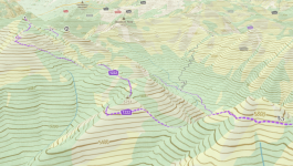
It also has a 3D option for Computer / Samsung phone & tablets which is pretty neat:

1696571735059.png

With all this software, they all have pros and cons, I think the best option is to pick one, go all in and just learn it and it's workarounds.
 

nickw

Adventurer
Thanks for the help, I have deleted the app and also re-downloaded the .gpx files to my computer. I'll try the sync route first and if that doesn't work I will try to download the files directly to my iPad.

I am of the mindset that if I do something as simple as change a route color on my computer it should also change the route color on my iPad when I sync it and it does not do that.
It's how it is supposed to work. In the 3 years I've been using it I had the sync get out of sync once, I had to delete from phone and re-upload, all has been good since.
 

ovʀʟxnᴅ

Member
Gaia is a great app with an amazing feature set, but the interface is completely unintuitive and the naming conventions increase confusion. Overlay/layer and route/track have similar enough meanings outside of Gaia that very different words should have been used. Being able to drop your own waypoints with notes and pictures is great, when it works right. Sometimes the photos won't upload or download, sometimes duplicate points are created without photos. It's annoying. Also, the route/track organization is just awful. We're all used to a simple drag and drop folder structure. After many years, I still have no idea how to really sort what I have created, added, deleted, archived, and saved in the app.
 

DirtWhiskey

Western Dirt Rat
Agree with above on Gaias folder organization. Hate it. Layer database is unreal. Even has the far superior ESRI satellite imagery database.

Switched to Gaia after being a power user of BCN. Then a very well known database erasure event ruined that garbage app for me. Lost ten years of crucial wilderness water beta on the Colorado Plateau. Was able to recreate most of it. Miss the trip database structure though.

A note on the Gaia Topo layer. This layer is similar to Garmins base map layer that is optimized and compressed for the all. Main advantage is much smaller and faster offline downloads. I've found massive issues with Gaias base layer in the wilds. Had multiple FUBAR inaccuracies. An example: 8 days in wandering on the Wind River Indian Res. Late night walk turns into a near survival experience because the base layer didn't show 5 medium unnamed lakes in the North Fork of the Little Wind River drainage. They simply showed up as flat land. Luckily I always have a paper map backup but in the pitch dark forest, we got all sorts of turned around. Ended up climbing a knoll and getting my bearings by the stars. Everybody was beat dead after 17 miles of gruesome bush thwacking through a massive tree blow-down event. Not a fun night. So now I am sure to download the "Gaia Plus US Topo".

Sat imagery is a massive space killer, so I save that for small, critical sections. For example when you really need to know which section of the canyon rims in Southern Utah "go or not".

On X is a toy. Gaia has been adding hunting units as of late too. Public routes function is useful. Snap to trail is buggy at best. Gaia Pro includes lots of goodies like Outside mag puns (Climbing mag etc) subscription included. Yes it has its ticks but it's the only thing that does what it does.
 

DirtWhiskey

Western Dirt Rat
Gaia newbie here with Premium. I could not find this layer name on my iPhone. Any chance it has a different name? Thanks!

Sorry I misspoke. And I had a few beers. There are two layers in talking about "Gaia Topo". There are two versions, one just says Gaia GPS as a source and the other adsss open street map as an addition. Not sure what OSM adds. The plus of Gaia Topo is that they are constantly improving the basemaps. As of this writing the error I spoke of has been resolved. Support said it might have been some corrupted tiles. But I still download USGS topo for critical areas (much bigger download) to be safe.
 

Ralph_Fonz

New member
You need a solid tablet/phone/laptop to run GAIA. I was using a A series Tablet and it was a no go... I would suggest a S series w/ at least 8gb of ram and a current processor. Especially when using multiple layers.
I get gaia as part of my trailforks membership. I've used it religiously for about 3-4 years. It took about ~1yr to really understand it.
I get why most go to On-x. The simplicity like iPhone, but lacks great features (for now). A lot of Ipads are 4gb just FYI.
 

ovʀʟxnᴅ

Member
I've been running a 2nd hand iPad Air 4G for a few years now. It has been a solid choice, but there may be more affordable options out there.
 

RandyP

Adventurer
I have been using GaiaPro for many years. Started when it was created, owned and shared by two very enthusiastic (sp?) young people. Good friends that explored together and wanted a good mapping app. They grew it with an open community approach, asking for input. Complied suggestiosn and let the users select the changes they preferred. It kept growing and improving. Their app help was spectacular. They guided me thru my initial learning spell. I was just one of many GPS navigation app searchers that found GAIAGPS to my liking. The business was sold to Outside+ . Things changed. But the app is still available and supported.

Features I use a lot are creating Areas. Name the area and create a Area file for info in that area. Put all Waypoints, Routes, Tracks and Maps for that Area file in sub files, One sub fike for each type of info, ie Waypoints, Routes, Tracks and Maps sub-files. I start each sub folder name with an acronymn for the Area file (ie: North Death Valley area, NDV starts each sub file name. Yu can download all maps for an area, I choose to download one map type at a time. Helps organize date geographically. Note that the visability of any area file can be turned on/off, along with its sub files. Individually or as an area file, on/off visability. It seems that the app renders the map with all mapping info every time you move around the map. By turning off the areas you are not interested in at the time, rendering happens faster, the map runs smoother.

Creating an area can be done by creating a route around the perimeter of the area and then converting that route to an area.

I found that all my maps can be put in Maps sub files.
I have 43.24 GB of data on mny iPAD, still have 431 GB space still available on the iPad. I have additional data ARCHIVED on the GaiaPro webb site that I uploaded from my iPad. Mostly out of state areas or areas I do not visit often.

I like to use GaiaGPS Pro. I can make it work for me. I Don't necessarily like the user interface, support or the latest changes made for no apparent reason. I live with it. It works for me to plan adventures 4wheeling. One such adventure was an ORIDAVADAH 800 mile loop on dirt roads ORegon, IDAho, neVADa & utAH. I researched the route, downloaded the maps, created routes and waypoints. 90% of my route research was right on. Went from english descriptions of route, place names, geographic locations mentioned in a trip planning bulletin board to create my routes. Adventure was created lead by Brett from Twin Falls followed by about 8 of us. A seven night moving camp adventure. Use of Gaia GS made it possible for me to create the route I thought we might take, download all the Maps (GB'S of map data).

I'm getting old, brain fade. So I'll stop typing now.
 

nickw

Adventurer
I have been using GaiaPro for many years. Started when it was created, owned and shared by two very enthusiastic (sp?) young people. Good friends that explored together and wanted a good mapping app. They grew it with an open community approach, asking for input. Complied suggestiosn and let the users select the changes they preferred. It kept growing and improving. Their app help was spectacular. They guided me thru my initial learning spell. I was just one of many GPS navigation app searchers that found GAIAGPS to my liking. The business was sold to Outside+ . Things changed. But the app is still available and supported.

Features I use a lot are creating Areas. Name the area and create a Area file for info in that area. Put all Waypoints, Routes, Tracks and Maps for that Area file in sub files, One sub fike for each type of info, ie Waypoints, Routes, Tracks and Maps sub-files. I start each sub folder name with an acronymn for the Area file (ie: North Death Valley area, NDV starts each sub file name. Yu can download all maps for an area, I choose to download one map type at a time. Helps organize date geographically. Note that the visability of any area file can be turned on/off, along with its sub files. Individually or as an area file, on/off visability. It seems that the app renders the map with all mapping info every time you move around the map. By turning off the areas you are not interested in at the time, rendering happens faster, the map runs smoother.

Creating an area can be done by creating a route around the perimeter of the area and then converting that route to an area.

I found that all my maps can be put in Maps sub files.
I have 43.24 GB of data on mny iPAD, still have 431 GB space still available on the iPad. I have additional data ARCHIVED on the GaiaPro webb site that I uploaded from my iPad. Mostly out of state areas or areas I do not visit often.

I like to use GaiaGPS Pro. I can make it work for me. I Don't necessarily like the user interface, support or the latest changes made for no apparent reason. I live with it. It works for me to plan adventures 4wheeling. One such adventure was an ORIDAVADAH 800 mile loop on dirt roads ORegon, IDAho, neVADa & utAH. I researched the route, downloaded the maps, created routes and waypoints. 90% of my route research was right on. Went from english descriptions of route, place names, geographic locations mentioned in a trip planning bulletin board to create my routes. Adventure was created lead by Brett from Twin Falls followed by about 8 of us. A seven night moving camp adventure. Use of Gaia GS made it possible for me to create the route I thought we might take, download all the Maps (GB'S of map data).

I'm getting old, brain fade. So I'll stop typing now.
I like the idea of Areas - I'll do some research into how that works. I've been using Gaia for 3+ years now and it's a struggle to keep all the data organized, I have waypoints, routes and tracks all over the place. My biggest grievance with Gaia are the folder structures.
 

Umbrarian

Observer
If you sync your data with the GIAGPS GaiPRO 'cloud', You can view and edit it in many ways, if you view the data on the webb with a PC.
I just want a persistent sort option in my settings. Heck if it would just remember what I last used that would be great.
 

Forum statistics

Threads
188,028
Messages
2,901,390
Members
229,352
Latest member
Baartmanusa

Members online

Top