who is using a real gps vs a tablet

martnH

Member
Garmin oregon is touch screen. So does Garmin Montana

Try the Garmin topo map. It is very good in my area. All the relics sites, hiking trails, biking trails, fire trails everything's are there.

Often I find it much better than some off-road navigators like hema etc..

Sent from my LG-H870DS using Tapatalk
 
Our reasoning on using Google Maps over the typical GPS/Topo setup is that we really don't need to know the topo and we're drawn towards how the Gmaps is setup. In other words we're not thrilled about how most of the Garmin's or even the Rand Mcnally are set up.. these on screen maps with the topo's are very confusing. Just give us the 2D (looking down) view and nothing more.

I did a bit more exploring on the Samsung Tab A 8.0 today and down loaded my first map. But it's odd having Google say that if the map isn't updated it will expire.. so not sure what that mean. Plus How does one know what maps one needs until one actually needs them & by then it's too late cause you've lost your wifi connection..

Also as a follow up to the brightness adjustment, The Samsung does have a brightness adjustment & an auto brighter setup or system. Which when enabled.. the brightness is turned up or down based on the current light around you. Dare I say it, it's very annoying when the screen fades claiming that with the brightness turned up, can cause eye strain.. I'm sure there is some truth to that, but we would rather have the brightness up as much as possible (but staying out of the red zone)

What we really need is a gps/mapping system like Google maps, that can be installed. I know that Garmin and others have SD maps cards or have seen them. Let's suppose that we wanted to explore NC, then we would plug in a SD reader or chip with all the mapping done for us. But used like google maps which we'e grown accustomed to.
 

martnH

Member
If you don't need the topo info or even find them confusing, then we are not talking about the same thing here......

You can use whatever, or just read the street sighs, right?

Sent from my LG-H870DS using Tapatalk
 
@martnH

You're right, My bad. There is a difference between a real GPS system and a Tablet that use a mapping system. So my bad. Plus in our case there's always the good ole paper map.
 

JackW

Explorer
Any advice on using a Windows based tablet for navigation? I'm especially interested in something that will allow you to use tracks and routes from a Garmin GPS system on a Windows platform.
 

e60ral

2016 4Runner Trail w/KDSS
Any advice on using a Windows based tablet for navigation? I'm especially interested in something that will allow you to use tracks and routes from a Garmin GPS system on a Windows platform.

Garmin BaseCamp
 

e60ral

2016 4Runner Trail w/KDSS
Our reasoning on using Google Maps over the typical GPS/Topo setup is that we really don't need to know the topo and we're drawn towards how the Gmaps is setup. In other words we're not thrilled about how most of the Garmin's or even the Rand Mcnally are set up.. these on screen maps with the topo's are very confusing. Just give us the 2D (looking down) view and nothing more.

I did a bit more exploring on the Samsung Tab A 8.0 today and down loaded my first map. But it's odd having Google say that if the map isn't updated it will expire.. so not sure what that mean. Plus How does one know what maps one needs until one actually needs them & by then it's too late cause you've lost your wifi connection..

Also as a follow up to the brightness adjustment, The Samsung does have a brightness adjustment & an auto brighter setup or system. Which when enabled.. the brightness is turned up or down based on the current light around you. Dare I say it, it's very annoying when the screen fades claiming that with the brightness turned up, can cause eye strain.. I'm sure there is some truth to that, but we would rather have the brightness up as much as possible (but staying out of the red zone)

What we really need is a gps/mapping system like Google maps, that can be installed. I know that Garmin and others have SD maps cards or have seen them. Let's suppose that we wanted to explore NC, then we would plug in a SD reader or chip with all the mapping done for us. But used like google maps which we'e grown accustomed to.

Try GaiGPS and look at the OpenStreetMap layer
 

Byways

Adventurer
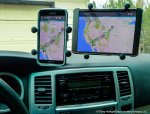
Here are a Samsung S5 phone and S2 tablet, both Android, in the interior shade of my 4Runner. Both display the same gpx track file and waypoints using the app GPX Viewer, by Vectura Games. (It works well for viewing, following and recording tracks.) No need for a dedicated GPS unit, or for a more complex app that requires many hours to learn.

smartphone & tablet windshield (1 of 1).jpg

For moto folks who are concerned about sunlight readability, here are a Garmin Montana 600 (left), Samsung S5 and Apple iPhone 5 (right) ...

GPS phone test (1 of 1).JPG

For moto use, I will continue to use my rugged, limited-purpose Montana.

In the 4Runner, the tablet and a simple, easy-to-learn and easy-to-use app work best.

In shade, used, older phones and tablets -- even discontinued ones -- can be an inexpensive, effective and versatile alternative to an expensive dedicated GPS unit or late-model smartphone. (Also can serve as a backup phone and/or wi-fi device.) For adventure/dual-sport riding, I won't subject a pricey phone to the abuse the Montana can take.

All of this said, I wonder: Are we making backcountry navigation seem more complex than it is?
 

SoCal Tom

Explorer
I’ve got a 5 year old garmin 1490 with the Cal topo map installed. I use it in conjunction with a older Lenovo tablet. The tablet screen is much bigger for seeing where I am, and the battery life is better, but the garmin is easy and the maps are in it.


Sent from my iPad using Tapatalk
 

Byways

Adventurer
Sounds like a good setup, TrailBadger. Typically, all one does when following a track (as opposed to a "route") is glance at the device every 20 minutes or so, usually at junctions. Unlike urbanized areas, in wildland terrain there's typically only one real road to follow, and junctions are the only issue, as well as monitoring progress.

I've never thought a topo overlay was anything more than screen clutter and still more to take your eyes off the road and terrain.
 

dstock

Explorer
My issue with tablets, be they Apple or Android, is the operating systems keep growing and eventually slow the tablets to a crawl. In addition, the tablets don't get the latest operating systems after a couple years so then you end up buying a newer tablet to keep up. Even if you go with cheaper Android tablets, you are still in the $100-$300 range to get something relevant. Also, newer versions of the apps don't always work on the old operating systems, like Gaia GPS won't run on Android Lollypop 4.1.2

My Garmin Zumo purchased in 2007, which pulls double duty on the motorcycle and in the car, still functions, does routing on the fly, and I have lifetime map updates. It was in the $500-600 range when I purchased it 10 years ago.

I go back and forth with this issue after trying so many apps, eventually the Zumo will die and I will have to make a decision on how to replace it. Threads like these are helpful in sorting out a direction, thanks all for the info.
 

SoCal Tom

Explorer
My issue with tablets, be they Apple or Android, is the operating systems keep growing and eventually slow the tablets to a crawl. In addition, the tablets don't get the latest operating systems after a couple years so then you end up buying a newer tablet to keep up. Even if you go with cheaper Android tablets, you are still in the $100-$300 range to get something relevant. Also, newer versions of the apps don't always work on the old operating systems, like Gaia GPS won't run on Android Lollypop 4.1.2

My Garmin Zumo purchased in 2007, which pulls double duty on the motorcycle and in the car, still functions, does routing on the fly, and I have lifetime map updates. It was in the $500-600 range when I purchased it 10 years ago.

I go back and forth with this issue after trying so many apps, eventually the Zumo will die and I will have to make a decision on how to replace it. Threads like these are helpful in sorting out a direction, thanks all for the info.

I found the typical 4 or 5 inch screen gps units to be too small to work for me off road. If I had a question about whether to go up this wash, or that wash I couldn't make the screen show me enough to make a proper decision. The tablet I'm using is already too old to upgrade the firmware, but it displays topo maps just fine, and it was under $150 when I bought it. Its got a 9 inch screen, so I can see enough detail and far enough ahead to make a decision. I've turned off auto updates, so until I decide I can't take it anymore this is what I have ( FWIW, this tablet is now old enough that I have a newer iPAD for my regular use, this one is essentially a dedicated GPS now)
 

Byways

Adventurer
I hearya, dstock.

My Garmin Montana, a few years old now, works well on both the dual-sport bike, in my SUVs, cars, etc., and in my hand, with both tracks and routes. It has taken a beating. Even though smartphones and tablets work with tracks, I do not believe they are ready yet to replace a backcountry- and outdoors-capable unit like the Montana.

I am curious: Will your 2007 Zumo load and work with tracks (as opposed to "routes")? Every season I must respond to cries for help from folks who want to use their very highway-capable Zumos for backcountry travel.

As this is something I deal with often among clients who are new to GPS-guided backcountry travel, permit me to expound some, and even risk going off-topic some ...

For backcountry use, tracks are consistently the most reliable. Zumos, I believe, automatically convert "tracks" to "routes" upon loading. That is how they are able to reroute "on the fly." I believe older Zumos were oriented to using "routes," and not "tracks."

GPS units cannot reroute when using "tracks," and for backcountry use that is a good thing. That makes tracks the most reliable tool for wildland travel, even though tracks will not provide audible and visual alerts to upcoming turns and such. I always discourage the use of routes, which are dynamic and which the GPS unit can change; in favor of tracks, which are static and which the unit cannot change.

Of course, this assumes that the human who made the track -- either on a computer, or by recording it while traveling -- got it right.

In the wild, it is ill-advised to allow a GPS unit to reroute, unless one really, really knows what is going on and what the risks of doing so are. There are innumerable tales of unfortunate outcomes that occurred when a GPS unit was allowed to reroute a "route" line based on its internal Garmin map product. That is because Garmin's maps -- City Navigator, in particular -- are cartographically unreliable. Garmin is a tech hardware company, not a cartographic company.

In wildland settings, City Navigator (Garmin's primary mapping/routing supplement) is a good tool as long as one is attentive to its limitations. It includes roads that haven't existed in decades, roads that have been in wilderness areas for years and so are now off-limits, roads across posted and gated private land, and roads that fell into disuse decades ago and really don't exist anymore. I deal with these issues continually, every season across many states.

"Route" lines adhere (or not) to lines in the GPS unit's internal maps. To reroute, the unit will use the roads depicted on those internal maps ... even if those roads no longer exist or if the map's road lines have disconnected segments that force the unit to draw a route line in some crazy, non-sensical manner.

"Tracks," on the other hand, do not use the GPS unit's internal map. Tracks are just lines, like lines drawn on a blank sheet of paper. You don't even need an internal map to follow or record "tracks."

"Routes" assume the internal map is accurate, and may be changed by the GPS unit to follow roads that do not exist. "Tracks" stay put, either where the human drew the track at the outset or where the unit drew the track while recording the user's travels.

Again, the context here backcountry use, for which I always urge the use of a track-friendly GPS unit. Best to test before launch.

All of that said, apps for following and recording tracks on smartphones and tablets are so inexpensive -- free, or just a few dollars -- that there is nothing to lose by having one or more loaded. I have several apps on several devices, more to become literate in the topic than actual use. Yet that is the way things are going, and Garmin has to be very concerned.

I hope this is helpful to someone out there ...
 

dstock

Explorer
I hearya, dstock.

My Garmin Montana, a few years old now, works well on both the dual-sport bike, in my SUVs, cars, etc., and in my hand, with both tracks and routes. It has taken a beating. Even though smartphones and tablets work with tracks, I do not believe they are ready yet to replace a backcountry- and outdoors-capable unit like the Montana.

I am curious: Will your 2007 Zumo load and work with tracks (as opposed to "routes")? Every season I must respond to cries for help from folks who want to use their very highway-capable Zumos for backcountry travel.

As this is something I deal with often among clients who are new to GPS-guided backcountry travel, permit me to expound some, and even risk going off-topic some ...

For backcountry use, tracks are consistently the most reliable. Zumos, I believe, automatically convert "tracks" to "routes" upon loading. That is how they are able to reroute "on the fly." I believe older Zumos were oriented to using "routes," and not "tracks."

GPS units cannot reroute when using "tracks," and for backcountry use that is a good thing. That makes tracks the most reliable tool for wildland travel, even though tracks will not provide audible and visual alerts to upcoming turns and such. I always discourage the use of routes, which are dynamic and which the GPS unit can change; in favor of tracks, which are static and which the unit cannot change.

Of course, this assumes that the human who made the track -- either on a computer, or by recording it while traveling -- got it right.

In the wild, it is ill-advised to allow a GPS unit to reroute, unless one really, really knows what is going on and what the risks of doing so are. There are innumerable tales of unfortunate outcomes that occurred when a GPS unit was allowed to reroute a "route" line based on its internal Garmin map product. That is because Garmin's maps -- City Navigator, in particular -- are cartographically unreliable. Garmin is a tech hardware company, not a cartographic company.

In wildland settings, City Navigator (Garmin's primary mapping/routing supplement) is a good tool as long as one is attentive to its limitations. It includes roads that haven't existed in decades, roads that have been in wilderness areas for years and so are now off-limits, roads across posted and gated private land, and roads that fell into disuse decades ago and really don't exist anymore. I deal with these issues continually, every season across many states.

"Route" lines adhere (or not) to lines in the GPS unit's internal maps. To reroute, the unit will use the roads depicted on those internal maps ... even if those roads no longer exist or if the map's road lines have disconnected segments that force the unit to draw a route line in some crazy, non-sensical manner.

"Tracks," on the other hand, do not use the GPS unit's internal map. Tracks are just lines, like lines drawn on a blank sheet of paper. You don't even need an internal map to follow or record "tracks."

"Routes" assume the internal map is accurate, and may be changed by the GPS unit to follow roads that do not exist. "Tracks" stay put, either where the human drew the track at the outset or where the unit drew the track while recording the user's travels.

Again, the context here backcountry use, for which I always urge the use of a track-friendly GPS unit. Best to test before launch.

All of that said, apps for following and recording tracks on smartphones and tablets are so inexpensive -- free, or just a few dollars -- that there is nothing to lose by having one or more loaded. I have several apps on several devices, more to become literate in the topic than actual use. Yet that is the way things are going, and Garmin has to be very concerned.

I hope this is helpful to someone out there ...
I am pretty sure I have loaded tracks onto the Zumo, but I will need to double check what it does with them once they are on there. Will have to report back on that one.

You raise a lot of very good points, and certainly most people have probably fallen victim to bad "auto-routing" at some point, even in town. I always go out with multiple options, Garmin, phone, tablet and even an InReach SE. I've been playing around more with the various apps, BCN, Gaia and Delorme/Garmin's Earthmate to see how they work. Too be honest, Earthmate is the easiest to use, possibly because it originated with a map company.

Great food for thought, thanks!
 

Forum statistics

Threads
188,217
Messages
2,903,946
Members
229,665
Latest member
SANelson
Top