Hole in the Rock, Utah!

Brett M

Adventurer
This one's over a year old, but I wanted to share it with you all :)


Cody, Steve (yakinaked) and I left from SLC around 8 pm Wednesday night with the intention of getting to Hanksville and camping there for the night. That was not to be the case though. About halfway between Price and Green River we have our first problem. Cody's ZJ shut's down for no reason and we can't get it fired back up. So, we end up pulling him to Green River and getting a room there for the night. Four dudes in one room...sharing two beds! lol

jeeppaint003bl0.jpg


Next morning, Cody replaces the coil and the Jeep fires up no problem.

jeeppaint008nw6.jpg


Off we go again to Hanksville. So we thought. Halfway between the two towns, the ZJ shuts down again.

jeeppaint013ya2.jpg


Coil again, so we thought. I pull him again to Hanksville where we all test and think of anything we can to get the Jeep going again. Nothing. Off go Steve and Cody to Price to get a new coil and CPS, just to be sure. I take off for Bullfrog, trying to beat the ferry for Halls Crossing. Make it exactly at three, which is when it's supposed to leave. Off to the other side I go.

jeeppaint021qi7.jpg


Ross (who was riding with Cody, but now with me) meet up with Kevin Fell (www.kevinsjeepparts.com) and just hunker down for dinner and some drinks. We're thinking we'll see Cody and Steve around 8 or 9 that night. Nope. 12:30 they roll in after fighting with getting the CPS replaced on the ZJ. No problems after that though.

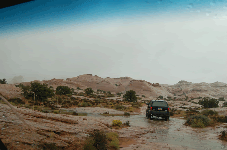
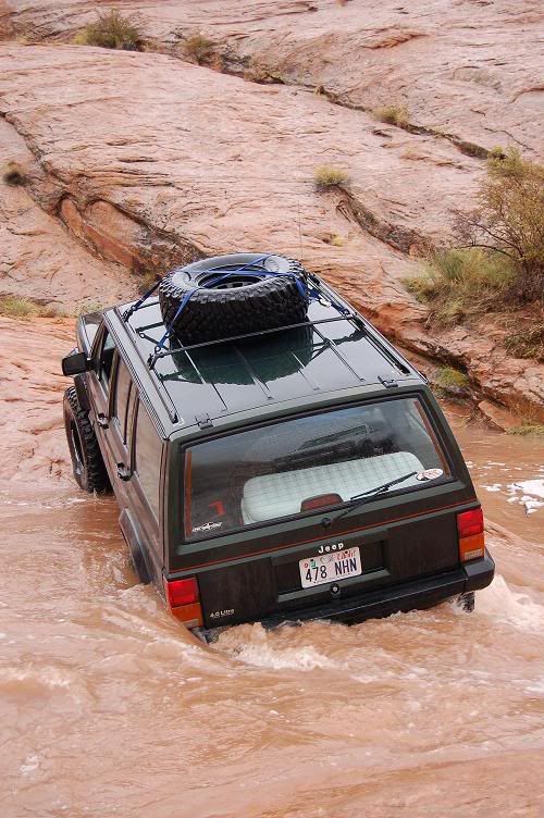
So, Friday morning we set off on Hole in the Rock. Great weather, sunny, warm perfect. On the way stopped for lunch at some old ruins before dropping down into the the wash.

jeeppaint038eh4.jpg


Kevin stepped up his ACOS spacers since he was bottoming out on his shocks.

jeeppaint043jl2.jpg


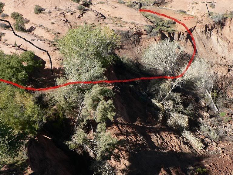
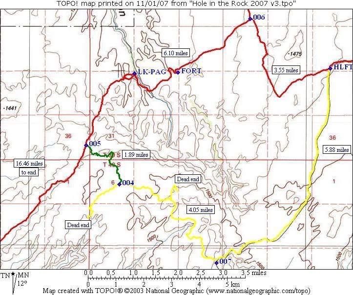
Down into the wash and off again. Here's Cody coming down one of the slick rock slopes. You can behind his Jeep where the Mormon settlers had blasted the rock to get their wagons through.

jeeppaint047po3.jpg


Another view as you drive through the spots where they blasted and chipped stone.

jeeppaint045gu8.jpg
 
Last edited:

Brett M

Adventurer
We get to the new bypass for the trail, since the canyon is washing out and where the road use to be is a 200 foot drop to the bottom. All the rain is just tearing it up. You can see about 300 feet further down the canyon the sign for the trail and where the road use to head up into the rocks. These pics below are the new bypass, where the old trail would just go up a sandy wash, you get to go up this now.

jeeppaint055cf2.jpg


jeeppaint059nr4.jpg


Good progress after that, you can see everywhere where the trail was cut though. They were pretty brave to be out there on that trek without knowing what was ahead of them. Another spot where you can kind of tell the road was cut with Steve coming down that spot.

jeeppaint068if7.jpg


Motoring on we go off and pass the sign for Grey Mesa, and up up a narrow wash.

jeeppaint071kh8.jpg


jeeppaint074ib2.jpg


jeeppaint076wd4.jpg


On that last climb up to where we decided to camp. It was getting to the point where we couldn't see much at all due to the sun being in our eyes. Not fun to be climbing and not being able to tell if you are about to fall off a cliff!

jeeppaint086zo1.jpg


This is what we camped by! :eek2:

jeeppaint090cu3.jpg
 

Brett M

Adventurer
Next day we start out again with it just pouring rain. Little waterfalls everywhere and of course we're driving up steep slick rock. I didn't take as many pics since I didn't really feel like taking a $1000 dollar Nikon out in the rain. :p We stopped up on top of Grey Mesa at a nice overlook of the San Juan river. You can see how low Lake Powell is with the water line on the cliffs.

jeeppaint108zb9.jpg


jeeppaint111xw1.jpg


We got to the "Chute" as I believe it's called and stopped to hike to the bottom to check out the river first before driving down. Wasn't too bad so down we go.

jeeppaint115ky7.jpg


jeeppaint123jz0.jpg


Kevin crossing the stream.....wait till later on that day for our suprise coming back!

jeeppaint136nx7.jpg


Here's Steve and then Cody coming down one of the drops on the trail, started to rain harder just after this again.

jeeppaint143sh0.jpg


jeeppaint146rp5.jpg


After this, I really have no more pics until we turned back and headed out. It was just a monsoon and rivers everywhere. One shot of Cody in front of me driving on the trail/river.

Jeep-Paint-148.gif


Then we got back to the small stream which now had grown quite a bit bigger!

JeepPaint153.jpg
 
Last edited:

Brett M

Adventurer
Sunday we just headed back out the trail, pretty much making as much time as we could. We got back to the bypass and found that another 20 feet of the cliff had fallen due to the rain the previous day. Lucky us. It was getting pretty close to the area where we would drop down. Oh well. Down we go!

jeeppaint198ax3.jpg


jeeppaint204vh8.jpg


jeeppaint208fw2.jpg


That's pretty much all unless I can get some more pics from others. We just ran back to the airport then down to Halls Crossing and across the ferry. No problems on the way home either!

And just for fun, here are some pics that I shot of the stars Saturday night.

jeeppaint172uy4.jpg


jeeppaint173fp1.jpg


jeeppaint180xa6.jpg
 

Brett M

Adventurer
And the pic you all have been waiting for (sorta)

fh010018szl5.jpg


Very far left is where you use to head up, though you can't see it. You can however see how the canyon is collapsing on itself.

Lake20Canyon20Drawing2.jpg
 
Last edited:

cruiseroutfit

Supporting Sponsor: Cruiser Outfitters
RE-RUN (I can't say repost as it wasn't on this site ;))


Update: I spoke with the BLM gal about the washout last week at the Monticello RMP meeting, they have re-routed the trail to avoid the bypass area, so its good to go. :cool:

However, I'm not sure if the sign on the other side is still there or not? If it is they might leave it as a "spur" to go check out the one-time lake. Not sure how they re-routed the trail, its alot further back then the bypass we were all using in the meantime (no climb up the steep slickrock/sand face).
 

Moody

Needs to get out more
cruiseroutfit said:
RE-RUN (I can't say repost as it wasn't on this site ;))


Update: I spoke with the BLM gal about the washout last week at the Monticello RMP meeting, they have re-routed the trail to avoid the bypass area, so its good to go. :cool:

However, I'm not sure if the sign on the other side is still there or not? If it is they might leave it as a "spur" to go check out the one-time lake. Not sure how they re-routed the trail, its alot further back then the bypass we were all using in the meantime (no climb up the steep slickrock/sand face).
Funny, I was going to ask about that...I hope to get down there sometime this year...


Great writeup. I enjoyed it just as much this time around.:rockon:
 

Brett M

Adventurer
cruiseroutfit said:
RE-RUN (I can't say repost as it wasn't on this site ;))


Update: I spoke with the BLM gal about the washout last week at the Monticello RMP meeting, they have re-routed the trail to avoid the bypass area, so its good to go. :cool:

However, I'm not sure if the sign on the other side is still there or not? If it is they might leave it as a "spur" to go check out the one-time lake. Not sure how they re-routed the trail, its alot further back then the bypass we were all using in the meantime (no climb up the steep slickrock/sand face).


That's why I said it's over a year old ;)

You must have asked that lady the same questions I did that night ;) haha

Here's a map of the LATEST bypass.

Hole20in20the20Rock202007.jpg


Red is the old trail through Lake Canyon and the area washed out. Green is the connection from the Nokai Rd (yellow).

PS, I think that they took down the old sign from what I rememeber in Lake Canyon. I remember seeing a pic somewhere (RME?) and it was just the two 4x4 stud's now, no plaquered.
 

cruiseroutfit

Supporting Sponsor: Cruiser Outfitters
Wow, that is a much different re-route then I expected... I'll have to check with the BLM. She gave us the contact info for their GIS specialist. He would have the latest & greatest. It would suck to bypass the fort IMO, and my favorite camp is in Lake Canyon

HITR%20093%20%28Small%29.jpg


Actually, the gal told both of us that night... you were standing right next to me. I just asked more questions later. Your losing your memory old freind :shakin:
 

Brett M

Adventurer
cruiseroutfit said:
Wow, that is a much different re-route then I expected... I'll have to check with the BLM. She gave us the contact info for their GIS specialist. He would have the latest & greatest. It would suck to bypass the fort IMO, and my favorite camp is in Lake Canyon

http://www.cruiseroutfitters.com/content_images/photogallery/HITR_Dec2006/HITR%20093%20%28Small%29.jpg[IMG]

Actually, the gal told both of us that night... you were standing right next to me. I just asked more questions later. Your losing your memory old friend :shakin:[/QUOTE]

Pretty sure that's the same route she described to me, matching the map.

And I'm not getting old, I asked her when it was just Dom and I hanging out for an hour there ;) :shakin:
 

Forum statistics

Threads
185,895
Messages
2,879,533
Members
225,497
Latest member
WonaWarrior
Top