2.1 millon acres gone - Omnibus Public Land Management Act of 2009

teotwaki

Excelsior!
I think man has had his chance and blown it pretty good... Beyond that, Psalm 115:16 is but one religious viewpoint.

Showing a photo of you and your family at a wide spot in the road within a National Park further reinforces Jonathan's arguement.

You spelled argument incorrectly.

That nice family photo looks like Moran Point on the 4 Mile Trail up to Glacier Point. http://www.nps.gov/yose/planyourvisit/upload/yosevalley2008.pdf


Maybe you could have asked Nathan where it was before declaring it to be a "wide spot in the road"?
 
Last edited:

paulj

Expedition Leader
In California, the ability to drive TO IT is being jeapordized. I am all for hiking up the mountain, but let me cross the desert and foothills to get to it!

I'm still waiting for an example where Wilderness designation has prevented you from driving to that kind of hiking destination.

I don't expect photos, but I would like to see a map with wilderness boundary, and marked road. The best I can find is a pocket-wilderness just off of US395 that was part of the California Desert Protection Act, one that actually has 'trail' in its name. I have no idea how drivable it was before the Wilderness designation.

There were a few photos of tracks leading past Wilderness boundary markers, but it was hard to tell much of the history or extent of those tracks. Are they user generated ones? Do they really go somewhere, or they just stubs?
 
Last edited:

paulj

Expedition Leader
Speaking of attempts by Boxer etal to CLOSE all access to the California outdoors, what can you tell me about the propose Wilderness areas in Riverside Cty in HR369 (Boxer and Bono Mack)? That has language specifically preserving road access in one the areas

  • (g) Orocopia Mountains Wilderness Additions- .... except that the wilderness boundaries established by this subsection in Township 7 South are intended to exclude--

    • (1) a corridor 250 feet north of the centerline of the Bradshaw Trail;

    • (2) a corridor 250 feet from both sides of the centerline of the vehicle route in the unnamed wash that flows between the Eagle Mountain Railroad on the south and the existing Orocopia Mountains Wilderness boundary; and

    • (3) a corridor 250 feet from both sides of the centerline of the vehicle route in the unnamed wash that flows between the Chocolate Mountain Aerial Gunnery Range on the south and the existing Orocopia Mountains Wilderness boundary.
http://thomas.loc.gov/cgi-bin/query/F?c111:1:./temp/~c111aBoT6g:e2416:

The act as introduced by Bono in the House
http://bono.house.gov/news/DocumentSingle.aspx?DocumentID=75515

Latest Bono news release on this act:
http://www.bono.house.gov/News/DocumentSingle.aspx?DocumentID=114999
A fact sheet for this Act claims:
This Legislation Will NOT:
- Close roads that are currently open to the public
- Affect private land
- Prohibit hunting, fishing, or horseback riding
- Prohibit currently authorized off-road vehicle use or livestock grazing
- Prevent government agencies from fighting wildfires or from managing vegetation to reduce fire danger

Are there any other pending 'closure' actions by the California Senators?
 
Last edited:

paulj

Expedition Leader
Yes, I do feel that the more areas allowed to recreate in, the overall impact is reduced. In the areas that I have seen closed, they were not abused or trashed prior to the closure, but the areas remaining open have become more worn, trashed, eroded, thrashed, defaced, etc... as the usage is abnormally concentrated to those few remaining areas.

Could you be more specific about which type of closure you have in mind? Few, if any of the Congressionally designated Wilderness areas were created because they were abused or trashed. In nearly all cases the designation was intended to prevent development, including the creation of roads by the FS or BLM.

Closures based wildlife protection, especially under the endangered species act, might include abused areas, though, more likely the action occurred before abuse got too bad.

I suspect most closures of off road play areas are administrative actions. They are more common on public land close to urban areas, and prompted as much by complaints by adjacent private land owners. Those kinds of closures are the most likely to spread abuse to adjacent areas.

Another reason for closure is watershed protection. While the Central Valley Water Board is only pushing for more a more regulated use of the Rubicon, the strictest area closures that I am aware of have been enacted by cities seeking to protect their water supply (Seattle and Victoria come to mind), not federal agencies.
 

paulj

Expedition Leader
Speaking of abuse spreading to unprotected areas, is there an implied threat in this Rubicon Trail Foundation form letter?
http://www.rubicontrail.org/newstuff/
6. If the Rubicon Trail is closed, for any reason and at any time of the year, I will choose, at the same time of the year, a different trail in El Dorado County or an adjacent foothill county, to recreate in my, or as a passenger in someone else’s, off-highway vehicle.

It almost sounds as though they are saying 'if I can't #$*@ on the Rubicon I'll go do it else where'.

Such a letter ignores the actual recommendations of the Water Board staff, which are no more restrictive than existing seasonal road closures in Eldorado Nat. Forest.
 

kellymoe

Expedition Leader
This was bound to happen with the high travel the area sees. Most backpackers know to either use a wag bag or do your business away from water and drainage areas, how many off roaders know the same, especially the rock crawler crowd? For many who do the Rubicon it's the only time they camp and are not familiar with how to do the doo.


On Thursday, April 23rd the California Water Quality Control Board is having a public hearing in Rancho Cordova to finalize their decision on closing the Rubicon Trail.

MEETING PLACE AND TIME:

LOCATION – 11020 Sun Center Drive # 200; Rancho Cordova, CA 95670
DATE & TIME – Thursday, April 23rd @ 12:30 PM
 

teotwaki

Excelsior!
Speaking of attempts by Boxer etal to CLOSE all access to the California outdoors, what can you tell me about the propose Wilderness areas in Riverside Cty in HR369 (Boxer and Bono Mack)? That has language specifically preserving road access in one the areas

http://thomas.loc.gov/cgi-bin/query/F?c111:1:./temp/~c111aBoT6g:e2416:

The act as introduced by Bono in the House
http://bono.house.gov/news/DocumentSingle.aspx?DocumentID=75515

Latest Bono news release on this act:
http://www.bono.house.gov/News/DocumentSingle.aspx?DocumentID=114999
A fact sheet for this Act claims:

Are there any other pending 'closure' actions by the California Senators?

WashingtonWatch.Com says: This bill has been mooted by the passage of another bill on the same subject or by other events. Check 'Related Bills' below to see if other bills on this subject have been passed into law. Mooted: 3/30/2009

They are referring to the OPLMA of '09 so we'd have to try to see how the two bills overlap, I guess. Smells like work.

As to "preserving" road access. Those are just a few trails and that area is only 4,635 acres out of the 191,000 being closed to vehicular access. I think that I have been there quite a number of years back. There is an interesting Camp Billy Machen out that way. http://ludb.clui.org/gmap/?uuid=CA3259 not too far from The Slabs
 

sinuhexavier

Explorer
You spelled argument wrong.

That nice family photo looks like Moran Point on the 4 Mile Trail up to Glacier Point. http://www.nps.gov/yose/planyourvisit/upload/yosevalley2008.pdf


Maybe you could have asked Nathan where it was before declaring it to be a "wide spot in the road"?

Thank you spelling police. ;)

I meant no disrespect towards Nathan and apologize if it came off that way. I just don't agree with him at all and I feel as though I have been civil in my discussion.

As to your comment about Moran point, I have to respectfully disagree. Based on the angle of Half Dome in Nathan's image the camera is clearly looking down as Clouds Rest is above HD's horizon line. If the photo had been taken from Moran point Clouds Rest could not be above Half Dome because of Moran Points lower elevation. In fact I would have to say it is on the flanks of Sentinel Dome after further inspection. Which is not a wide spot in the road, so I was wrong on that one...
 

kellymoe

Expedition Leader
I'm still waiting for an example where Wilderness designation has prevented you from driving to that kind of hiking destination.

I don't expect photos, but I would like to see a map with wilderness boundary, and marked road. The best I can find is a pocket-wilderness just off of US395 that was part of the California Desert Protection Act, one that actually has 'trail' in its name. I have no idea how drivable it was before the Wilderness designation.

There were a few photos of tracks leading past Wilderness boundary markers, but it was hard to tell much of the history or extent of those tracks. Are they user generated ones? Do they really go somewhere, or they just stubs?

Lots of trails were closed after teh DPA in the area surrounding Death Valley.

The first picture is a road that was closed after the DPA, it is located in the northwest corner of Death Valley Nat. Park. It didnt realy go anywhere except from point A to point B, but it was a fun challenging trail that we did every year. The road is called the Jack MMM Flat road.

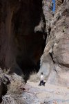
The next picture is of my son in a slot canyon in DVNP that was included after the DPA. It is about 4 miles off the Steel Pass road and used to be accessible by a easy 4x4 trail. There are numerous petroglyphs and pictographs in this canyon, outside of Newspaper Rock in Utah I have never seen so many picto's and petro's in one place, it is truly amazing. This is one closure that is a good thing IMO, except for some mid 1800's graffiti the place is untouched and unknown by all but a very few.

Eureka Valley had many roads on the west side of the valley that were also closed after the DPA. These are just few that come to mind. There are many more.

I dont know what exactly your looking for, there were roads closed that used to be open. It almost seems like you dont believe roads were closed. What exactly is the point you are trying to make? I am not being confrontational I just want to answer your question more accurately.

Some closures were good such as the slot cyn access road and some were just reactionary without much thought put into it. I am sure there is a map online somewhere that has the roads and their status but I am not going to sift through the net to find them, if you like I can keep giving more firsthand knowledge of closed roads.
 

Attachments

  • oldschool 041.jpg
    oldschool 041.jpg
    538.6 KB · Views: 22
  • 100_0624 (3).JPG
    100_0624 (3).JPG
    77.4 KB · Views: 23

teotwaki

Excelsior!
Speaking of abuse spreading to unprotected areas, is there an implied threat in this Rubicon Trail Foundation form letter?
http://www.rubicontrail.org/newstuff/


It almost sounds as though they are saying 'if I can't #$*@ on the Rubicon I'll go do it else where'.

Such a letter ignores the actual recommendations of the Water Board staff, which are no more restrictive than existing seasonal road closures in Eldorado Nat. Forest.

Don't single out the (lame) comments of the 4x4 crowd. Research some of the comments from the anti-4x4 crowd too. As I understand it, the Rubicon is the only trail not closed in the winter so the "I'll go elsewhere" is mostly posturing.

It is not just the 4x4 crowd that is damaging water quality:
Due to the road usage and lack of road maintenance during the early 1990's, stormwater runoff containing significant quantities of waste earthen materials from the roadway discharged to McKinney Creek and its tributaries. In 1994 the Regional Board adopted Cease and Desist Order No. 6-94-20 against Placer County for unauthorized discharges of waste earthen materials from the McKinney-Rubicon Springs Road (Rubicon Road) to McKinney Creek. The Cease and Desist Order required Placer County to implement water quality improvement measures.
Source: http://www.waterboards.ca.gov/lahon...able_documents/e_o_reports/2001/january.shtml
 

paulj

Expedition Leader
Apparently the Water Board staff took these 'I'll go elsewhere' affidavits as an attempt to claim that closing the Rubicon (even for part of the year) would have an adverse affect on the environment in other areas, and hence not allowed under CEQA (the Calif. Env. Quality Act). In effect, trying to play one aspect of the California law against another.

Page 7 of the attachment B, response to comments (link on the Rubicon closure thread)

CEQA
1. Water Board staff received comments that the Water Board’s adoption CAO would not comply with CEQA. One issue brought up is the potential to shift the environmental impact from the Rubicon Trail to other locations. The Rubicon Trail Foundation submitted 1,643 affidavits from Trail users that state they would move to another location to recreate if the Rubicon Trail was closed at any time of the year.

Response: The seasonal closures are consistent with nearby Eldorado National Forest closures of native surface trails. The extent of the closures that would be imposed by the Central Valley Water Board, should the Board choose to adopt the Order as proposed, would fall within the scope of several CEQA categorical exemptions.
 

paulj

Expedition Leader
I dont know what exactly your looking for, there were roads closed that used to be open. It almost seems like you dont believe roads were closed. What exactly is the point you are trying to make? I am not being confrontational I just want to answer your question more accurately..

I am trying to understand why people act as though every Wilderness designation is an irreparable loss to their recreational interests and personal rights. Most places where I have looked, Wilderness boundaries deliberately exclude preexisting roads.

I am learning from your examples, and a bit of my own digging, that there are some exceptions to this, primarily in the California desert, and in and around Death Valley NP in particular. I am trying to get a clearer understanding of those exceptions. Did someone, either during the writing of the legislation, or later administration of the act consider them to be too informal to exclude? Are they blocked because of their inclusion in the NP, not because of their inclusion in a designated Wilderness? There are, for example, backroads that remain open in Death Valley. The Saline hot springs and its access road probably is cherrystemmed out of any adjacent Wilderness areas.

Basically I am trying to get a clear picture of just how much Wilderness designations have inconvenienced backcountry expedition style travelers. That would include roads that I might be interested in driving, whether in my current cute-ute or something more capable (like a Tacoma). I am less interested in how various administrative actions (by FS or BLM) have limited the play areas open to ORV, especially ATVs that can leave roads and tearup mountain meadows.
 
Last edited:

paulj

Expedition Leader
Here's a chance to tell the NP service your thoughts about Wilderness areas within Death Valley NP. They are working on a Wilderness Stewardship Plan
http://www.desertusa.com/desertblog/?p=5629

Here's a report about a court case in which Inyo County claimed the right to pave 3 routes through Death Valley NP. They were basing their claim on 2477, which I believe some Utah counties have tried to use. I think one paved parts of the Burr Trail under that pretext.

Greenwater Canyon, on the east side of the National Park, is rugged, narrow, and deep, carving a twisting course through volcanic rock. Forty-two prehistoric sites containing more than 300 important petroglyphs are found in the Canyon, which also provides habitat for desert bighorn sheep and desert tortoise.
http://www.npca.org/media_center/press_releases/2006/page-28877401.html

Surprise Canyon near the Balarat Ghost town is another site of a 2477 battle. This is a 'constructed highway' under that civil war law (supposedly). The canyon is cherrystemmed, so it is the canyon ecosystem that is at the center of the battle, not the Wilderness Act.
http://www.4x4now.com/trcasc8.htm
trcasc8b.jpg


A list of these, and other 2477 'roads' from Mother Jones
http://www.motherjones.com/environment/2007/06/lost-highways-0
 
Last edited:

nwoods

Expedition Leader
Nice analysis!
This could be a fun game, and a bit more productive...
My guess is:
37°43'32.52"N, 119°34'53.49"W
(.4 or so miles from a wide spot)

Closer.....but not quite on the mark.

It's the top of Sentinel Dome, 1.1 miles from the flatspot on the side of the road. Probably one of the greatest short walks in the world considering effort expended verses views experienced. Admittedly, not the best example of hiking with kids, but I love the photo.

The Sentinel Dome trail is short (2.2 miles round trip). You walk a short bit of fairly level trail, then the Dome comes into view with tiny dots of people on it and you're thinking, "Man, I hope I can get my kids up that!", then you go around to the east side shoulder and it's an easy climb to the top, where you get one of the best views in the western United States.


Clouds Rest is on my list of peaks I want to climb. Haven't done it yet, but sure want to. Every time I go to Yosemite, I am drawn to it. I will do it some day.
 

kellymoe

Expedition Leader
I am trying to understand why people act as though every Wilderness designation is an irreparable loss to their recreational interests and personal rights. Most places where I have looked, Wilderness boundaries deliberately exclude preexisting roads.

I am learning from your examples, and a bit of my own digging, that there are some exceptions to this, primarily in the California desert, and in and around Death Valley NP in particular. I am trying to get a clearer understanding of those exceptions. Did someone, either during the writing of the legislation, or later administration of the act consider them to be too informal to exclude? Are they blocked because of their inclusion in the NP, not because of their inclusion in a designated Wilderness? There are, for example, backroads that remain open in Death Valley. The Saline hot springs and its access road probably is cherrystemmed out of any adjacent Wilderness areas.

Basically I am trying to get a clear picture of just how much Wilderness designations have inconvenienced backcountry expedition style travelers. That would include roads that I might be interested in driving, whether in my current cute-ute or something more capable (like a Tacoma). I am less interested in how various administrative actions (by FS or BLM) have limited the play areas open to ORV, especially ATVs that can leave roads and tearup mountain meadows.

I am intimately familiar with Death Valley and the Saline Valley area even more so. In DVNP the roads that saw the most traffic and were the most tourist worthy such as the Devils Racetrack remained open. There were however hundreds of miles of lesser traveled more remote roads that were closed. As I mentioned earlier some of the closures helped protect fragile places while others were just roads to random mining claims and remote valleys.

The "backcountry expedition style traveler" as you stated was greatly impacted by many of these closures. Finding a remote corner of Death Valley became a difficult thing to do after the closures. Now a backcountry traveler is relegated to the same highly traveled roads that everyone else is traveling. Some of the more remote roads in DVNP are Lippencott and Steel Pass, it used to be you rarely saw a vehicle on these roads now you can count on seeing at least a group a day on them where before it was a group a week. There are at dozens and dozens of roads that stem of these main arteries that take one back to remote valleys and canyons that you could spend a week or more in and never see another soul, this is just not the case anymore.

DVNP really does not lend itself to backpacking, these remote roads allowed one to get away from it all really away from it all. Thats my gripe.
 

Forum statistics

Threads
188,477
Messages
2,905,446
Members
230,494
Latest member
Sophia Lopez
Top