You are using an out of date browser. It may not display this or other websites correctly.
You should upgrade or use an alternative browser.
You should upgrade or use an alternative browser.
Creating a Cross Canada Overland Route
- Thread starter deadly99
- Start date

Granite Lake, Ontario...great informal camp spot :deal. Warm water, sandy beach, cliffs to jump from, etc

Young ladies in the mud :wink: (yes they are of age..it's just you who is getting older)

Does the Granite Lake campground look like it's heavily used? Is it all trashed? I'm always on the lookout for nice, accessible campgrounds, that aren't trashed. Very hard to find as you can imagine.
There's this one amazing spot on Lac Dumont in Quebec, spectacular camping on a bluff above a long sandy beach on a beautiful untouched lake, facing west... but it's crowded in the summer, and you can't walk in the woods without risking stepping in somebody's unburried poo. And you never know when somebody will show up with a loud stereo. One time we were there, they had a cube van full of massive stereo equipment, and a band was going to be playing. I think that was May 2-4, or July 1st. Can't remember.
Where were the girls at? Wondering if that's what goes on at Granite lake because... that's the type of thing you see at Dumont too. Not a prude, but it's not really family friendly.
j=Paladin;779790]Does the Granite Lake campground look like it's heavily used? Is it all trashed? I'm always on the lookout for nice, accessible campgrounds, that aren't trashed. Very hard to find as you can imagine.
There's this one amazing spot on Lac Dumont in Quebec, spectacular camping on a bluff above a long sandy beach on a beautiful untouched lake, facing west... but it's crowded in the summer, and you can't walk in the woods without risking stepping in somebody's unburried poo. And you never know when somebody will show up with a loud stereo. One time we were there, they had a cube van full of massive stereo equipment, and a band was going to be playing. I think that was May 2-4, or July 1st. Can't remember.
Where were the girls at? Wondering if that's what goes on at Granite lake because... that's the type of thing you see at Dumont too. Not a prude, but it's not really family friendly.[/QUOTE]
Granite lake is informal camping, I've never seen anyone there before :ylsmoke:
2010 Status Update
2010 Status Update
Given that the year is ending, I thought it would be an appropriate time to inform everyone of the status of the TCAT project.
We now have folks involved from across the country helping out. Skibum69 is creating the route across Newfoundland. Juames is helping out with the route in eastern Ontario and western Quebec. Fab is creating the route across eastern Quebec. Kiffernathan is creating the route across Manitoba, Sask and Alberta. Manxman is routing the bulk of BC. I’ll be filling in the missing pieces (Northern Ontario, Vancouver Island, Labrador, etc).
These folks have signed up to volunteer their time and energy for a not so glamorous job. Exploring dead ends, riding in the rain and cold weather, spending time away from your families, riding some fairly boring roads at times and all for no pay check. Each of us has received many suggestions for roads and trails which is just fantastic. This project would not be doable by one person (well, without being retired, having lots of funds or spending a dozen years) so it is with much gratitude that I say thanks. Thanks to the people for creating their sections of the route, thanks to the people who are helping them out and thanks to the folks who have offered their suggestions and volunteered to join us on our rides...THANKS!
The bulk of the TCAT has been plotted on maps; about half of it has been ridden. Next season (2011) will see most of the route being ridden and finalized.
I will be riding next spring with Fab and seeing his section of the route. It looks brilliant and I cannot wait to ride eastern Quebec for a week. Later in the year I’ll be spending a few weeks up in northern Ontario trying out a mapped route that has been put together with the help of some local input. It looks promising indeed.
In the summer of 2012 I will be heading west with a group of lads and riding the western half of the route. The plan is just beginning to come together but it looks like we’ll be meeting up with Kiffernathan and Manxman along the way and getting a “guided” tour of the TCAT. It’ll be very freaking cool to ride all of this stuff that I have been gazing at on some maps and a computer screen. I hope to be able to offer an open invite to anyone who would like to come along for a day, week or to ride the entire western half with us. It’s a long way off but as the date gets closer a schedule will get put together with some dates and times for meet up locations. Should be a great way to spend a summer
GISdood has signed up to create the maps and keep some order to the raw data we’re feeding him (tracks, google maps, etc) and will be creating the end gps product and maps for the guidebook. After much debate and input from many folks we have decided to distribute the route in this format.
· one gpx file per section
· a section being 2-3 days of riding or a 1000 km’s or a logical spot for a section to end (where an island ends, the prairies meet the mountains, end of a very long road, etc)
· each gpx file will have multiple tracks labelled sequentially and by province
· each gpx file will have waypoints for gas stops
We have decided not to include routes and have chosen tracks for obvious reasons, the biggest being that maps vary from one gps unit to another and many of them do not show the roads/trails the TCAT travels. Many gps units do not accept tracks, we understand this and it made it a hard decision. But in the end a choice had to be made, it is my feeling that if someone is spending months on the road travelling this route, a couple of hundred bucks for a track capable unit is probably just a drop in the bucket compared to tires, oil changes, food, gas and so on. Of course some people may decide to alter our gpx files and create routes and use them as direct routes, that your choice. We looked at doing maps, road books, routes and what not but in the end we choose this means to distribute the TCAT, we hope everyone will agree it makes the most sense. The GPX files will be distributeted from our web site at no charge.
Here’s a sample of one section.

You can see how the Technical Sections (5 of them in this section) intertwine with main route. The Main Route is designed to be “doable” by big bikes and by trucks (land rovers, suv's, jeeps, etc). The bulk of the main route consists of non paved roads. Some are narrow, some are wide gravel highways and in a few spots may be challenging for some folks. As the final route has yet to be completed I can only guess based on what I have seen so far but it looks like approximately 10-15% of the main route is on paved roads (they are called dual sport bikes). From experience some of these paved sections are pretty exceptional (scenic, twisty, hilly, etc). Some of the paved roads are not so glamorous and are used to connect gravel roads, nature of the beast and cannot be avoided. We have all tried to limit the amount of asphalt wherever possible.
The Technical Sections offer exactly what the title says, tracks that are more technical than a gravel road. Again I can only guess as the route is not completed but I think there will be approximately 20-30 technical sections on the TCAT. Mud, water crossing, narrow trails, steep hills, etc are what can be expected. They are not crazy enduro type terrain, but rather challenging terrain for a fully loaded travel enduro bike. I will have ridden every one of them on my 500 pound bike loaded with gear and will confidently be able to say that they are “doable”. This is a real grey line, we realize that but we are doing our best to not add anything that WE deem to crazy, for some these sections may be lame (I doubt it) and for others they may be considered crazy. Time will tell, all I can say is that I will have done each of them and I consider myself nothing more than a strong intermediate rider.
Antronax has joined the team and is going to be creating the logo's for the TCAT and some other graphic design type of stuff. This is a huge help to the project Among other things he is contributing is a template for the guidebook.
I have just begun to work on the guidebook. The intent is to have a 250+- page book that will be available for sale. It will include a write up for each gpx file (or section of the route) with some history, geography, pictures, a detailed map and more importantly a description of the terrain and what folks can expect over the next few days of riding. There will be a charge for the guidebook with proceeds going to try and keep our web site alive. As I mentioned I have just begun to wrap my head around this part of the project and I am beginning to realize that writing a book is no small thing. My wife has generously volunteered to be the editor, which is huge because my grammar and spelling is...well....not so great.
A quick sample (first draft, no template, bad spelling mistakes, etc) just to give you an idea of what I am thinking about. In my experience it is best to just start doing it, putting pen to paper so to speak and begin. Of course this will get revamped, updated and probably won't even be in the book but starting as they say is the hardest part.

In summary I am very excited with how far we got this year. I am simply blown away by the folks who have joined “the team” and are lending their expertise in a field or area of the country to try and make the TCAT something exceptional. The final product is beginning to become visible and to be honest it will be much better than I ever expected. I believe the mix of geography, cultures and terrain this route will offer will be second to none in North America for travel enduro bikes and 4 wheeled overland vechicles. I would never have made that statement 6 months ago, but I feel confident in saying it now because of the all the people helping out
The end goal of having the TCAT ready for distribution in the fall/winter of 2012 is still looking reasonable. I can't wait to do another one of these status updates next holiday season......
From my family to yours, we'd like to wish you a Merry Christmas and a Happy New Years
I'd like to do a shout out to some of the people who have got in touch with me and suggested roads, trails, scenic spots, etc
A HUGE THANK YOU
Andy from Alberta has been kind enough to send me some gps tracks in Alberta and BC and answered a kazillion emails with questions about the terrain, access, etc. Help like this is only adding to the overall project and will benefit the route significantly. Having local's help us out along the way is a big plus...THANKS ANDY :thumb
Andy
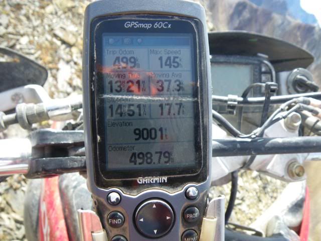
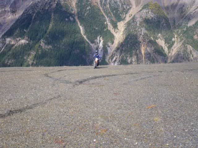
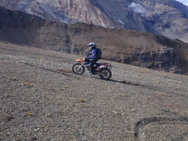
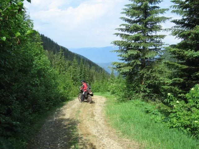
A potential "technical section" in Alberta :evil
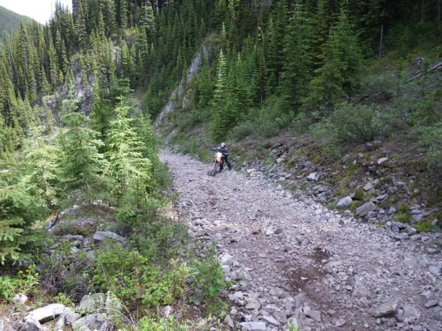
Potential for the main route through the East Kootenay's
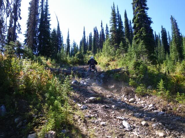
Potential: optional "Technical Section" near Invermere BC (East Kootenays)
Once again Andy, thanks for the tracks and photo's :freaky
A HUGE THANK YOU
Andy from Alberta has been kind enough to send me some gps tracks in Alberta and BC and answered a kazillion emails with questions about the terrain, access, etc. Help like this is only adding to the overall project and will benefit the route significantly. Having local's help us out along the way is a big plus...THANKS ANDY :thumb
Andy
A potential "technical section" in Alberta :evil
Potential for the main route through the East Kootenay's
Potential: optional "Technical Section" near Invermere BC (East Kootenays)
Once again Andy, thanks for the tracks and photo's :freaky
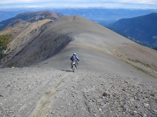
A question was asked on another forum of where that rideg photo was taken
As for the ridge.....up above Paradise Mines, shoulder of Mt Nelson near Panorama ski resort.
The pic (or so I have been told) involves a few hairy moments to get to and from...
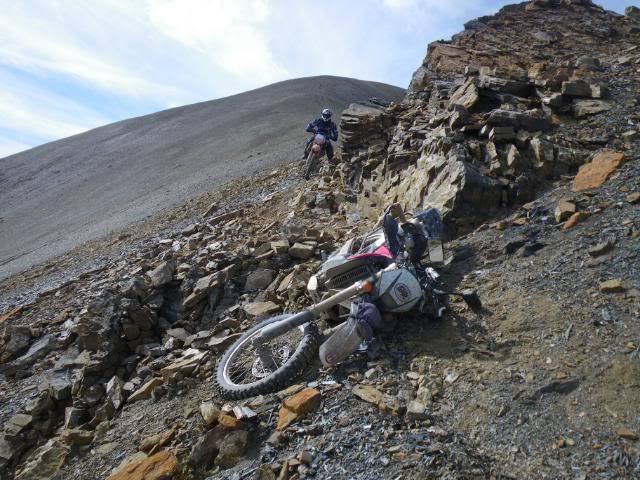
BUT Andy was also good enough to point oput an alternate route that goes up and over the ridge that may be more suitable for loaded large bikes :deal
All of Andy's info has been passed on to Manxman to consider as the majority of BC is his playground and he'll be planning the route through that section of Canada. Have fun Manxman :freaky Looks like some fun terrain you get to try out there in BC. Have I mentioned that I miss living in BC lately ?
As for the ridge.....up above Paradise Mines, shoulder of Mt Nelson near Panorama ski resort.
The pic (or so I have been told) involves a few hairy moments to get to and from...
BUT Andy was also good enough to point oput an alternate route that goes up and over the ridge that may be more suitable for loaded large bikes :deal
All of Andy's info has been passed on to Manxman to consider as the majority of BC is his playground and he'll be planning the route through that section of Canada. Have fun Manxman :freaky Looks like some fun terrain you get to try out there in BC. Have I mentioned that I miss living in BC lately ?
East Kootenays
Cross post in reference to the route through the East kootenay valley in BC
Cross post in reference to the route through the East kootenay valley in BC
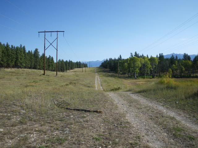
I think the "technical" reference was just the powerline that bypasses part of the Gray Creek route. It's often open sooner than the actual road as it doe not go quite as high, but the riding is much more interesting (and doable for a well-ridden big duallie).
I did Rose Pass twice last summer... only one tough (but short) climb, but would not recommend it as part of the main route given that we are targeting bigger bikes for this. But certainly could be an interesting alternative for smaller bikes. Should not be attempted before July as the St Mary river crossing can be pretty high and fast with spring run-off.
The route I suggested to Deadly99 for getting across the divide was Deadmans Pass. It is the first pass to the north of Coleman and is a nicer alternative to hwy 3
Koko Claims (also called Crossing Creek) is way too tough for the bigger bikes, but not a problem for a 650 or smaller thumper with a really good bash plate. Very loose baby head rock climb that seems to go on forever... but fun.
The route I suggested coming down from Canal Flats is the power line that runs just to the west of the hwy. It's a blast for high speed DS riding that is fine for all bikes.
Also the ride up to the Skookumchuk LO is not to be missed - great views of the valley.


Things have predictably slowed down now that winter has set in. ALOT of work has been happening behind the scene's. Discussions about route choices, much work on the guidebook, a logo for the route, designs for the maps, and choices on what and how to distribute the route.
The route will be distributed for free from our server ( www.advcanada.com )
It will be a series of GPX files based by province.
Each GPX file consist of several tracks following this naming convention
PROVINCE _ TYPE_NUMBER
examples
ONTmain001
ONTmain002
ONTtech001
main being the main route which is designed for well prepared suv's and loaded, large dual sport bikes.
tech being the optional technical tracks
A guidebook will be available from our site for a few bucks. The idea being that we can make enough money to keep our site alive in oder to distribute the GPS files. The book will have a brake down and explanation for each gpx file, province and track file. Lot's of photo's and as much histroy and other relvant information we can stuff into it.
We have also been filming all of our trips and may be throwing a dvd together as well.....
The idea being that the guidebook and dvd would help folks prepare for their expedition across Canada. We hope the guidebook would be valuable while on the route as well, the maps in particular should help folks out and reading about the next day's tracks should be valuable as well.
The interest folks have expressed in this project is much appreciated :smiley_drive:
As more information becomes available I'll do my best to update this thread. We have some fun trips planned for next season, northern Ontario, eastern Quebec, Newfoundland just to name a few. The other fellows creating the diofferent sections of the route also have some great trips planned and by the end of next summer we should have a very good idea of the final product.
Cheers for now
Ted

Have we seen the section north and NW of the GTA yet? You ARE going to use the Old Nippissing Rail trail... right? What about the Park to Park trail, which includes much of the Seguin trail... right? ")
Man, I need to get a rack system for my bike. And a big fuel tank. And a turbo.
Man, I need to get a rack system for my bike. And a big fuel tank. And a turbo.
Similar threads
- Replies
- 0
- Views
- 886
- Replies
- 3
- Views
- 1K
- Replies
- 8
- Views
- 994
- Replies
- 0
- Views
- 229