You are using an out of date browser. It may not display this or other websites correctly.
You should upgrade or use an alternative browser.
You should upgrade or use an alternative browser.
Exp.Ut. Southern Utah Traverse, Sept 09'
- Thread starter xjblue
- Start date
xjblue
Observer
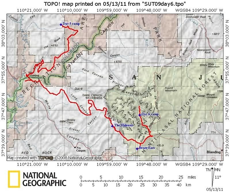
Day Six
I had slept out under the stars again while Adam was getting good at his arrangements in the JK and Jan was always pretty much ready to go waiting
on us to re-pack again. We made easy work of the road over Gunsight Pass, taking the right turn for NPS 633 taking us to Hite in very good time. Knowing
now how my good friend Alex must feel driving the lead vehicle all the time it was nice to take a break and have Adam out in front for a while, less dusty
for him too.


A stop for fuel and water in Hite then we were heading up the Woodenshoe Road, having crossed the mighty Colorado River with only the smallest
amount of pavement. Our next stop was a bit of a mystery, a spot on the map called the Hideout.

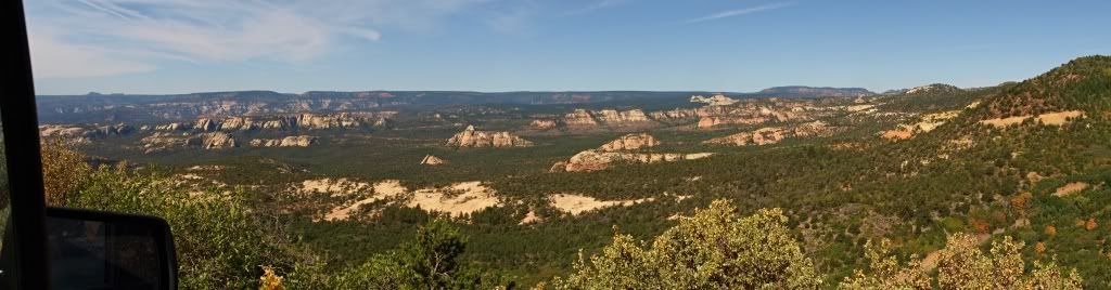
(Great scenery near the start of the Woodenshoe Road.)0909SUT-D6_20 by xjblue, on Flickr

Views of the Dark Canyon Wilderness area from the Woodenshoe Road.
The road at the Hideout seemed to end on private property complete with some locals about. Adam and I are pretty shy at happening upon strangers
land but Jan doesn't suffer from that problem and further explained from his experiences that a rancher would prefer to find out what your about rather
than have you lurking around suspiciously. So upon inquiring he received a warm invitation to us to come in and check out this thing called The Hideout.
Turns out it is just that, a small ranch house near a spring tucked under the rim and trees around the Woodenshoe Buttes at the head of Hideout Canyon,
formerly perfect for use by those on the dodge from the law. The friendly couple who live there in a small house through the summer and ranch there
with a son showed us the fixed up old bunk house next to their place and pointed out what direction the old ranch house used to stand. Remains
of a chimney are all that exist from it now days according to the man. The Hay shed was pretty much unchanged. They rattled off famous outlaws including
Posey and the Wild Bunch who used the place. They encouraged us to enjoy the view to the south toward Monument Valley out from the bunkhouse porch.
Would have loved to have had a recorder and pick their brains but we still felt like we were imposing a bit and moseyed off after a short visit, stopping for
lunch at a nearby meadow.

0909SUT-D6_23 by xjblue, on Flickr
The Hideout hay barn, if it could tell tales?
Our next stop was the Bears Ears followed by an overlook of Arch Canyon as lightning and heavy rain started to fall.

Adam's Jeep still wasn't running at optimum, so our proximity to the Colorado border, the rain storm developing overhead, and other worries [and comforts] at
home all perhaps helped him decide to make an early bid for the border. We parted ways at the Junction of the North Cottonwood Road which he took
after saying goodbye.
We had already reached the area I intended to camp, but with plenty of time left in the day and now not being sure what to do I settled on checking out
Peavine Canyon rather than hang out in the high country during the storm. In the pouring rain we drove to the trail head then carefully down the shelf
road in to Peavine Canyon and it's narrow corridor through the Dark Canyon Wilderness Area. The rain went away and at a suitable campsite, pretty sure
the same one we used during the Loose Screws Tour a few years previously, Jan stopped to set up camp while I continued to Dark Canyon not much further
to see Peavine Arch. Jan got a great fire going when I re-joined him and while sharing the canyon with a few loud youth wilderness rehab participants
and many loud cows, we had a long chat trading adventure stories (Jan has some great ones anyway) and talking about movies as the temperature
dropped and day slowly turned to night. Regrettably didn't get any photos of camp that night.

0909SUT-D6_25 by xjblue, on Flickr

I had slept out under the stars again while Adam was getting good at his arrangements in the JK and Jan was always pretty much ready to go waiting
on us to re-pack again. We made easy work of the road over Gunsight Pass, taking the right turn for NPS 633 taking us to Hite in very good time. Knowing
now how my good friend Alex must feel driving the lead vehicle all the time it was nice to take a break and have Adam out in front for a while, less dusty
for him too.
A stop for fuel and water in Hite then we were heading up the Woodenshoe Road, having crossed the mighty Colorado River with only the smallest
amount of pavement. Our next stop was a bit of a mystery, a spot on the map called the Hideout.
(Great scenery near the start of the Woodenshoe Road.)0909SUT-D6_20 by xjblue, on Flickr
Views of the Dark Canyon Wilderness area from the Woodenshoe Road.
The road at the Hideout seemed to end on private property complete with some locals about. Adam and I are pretty shy at happening upon strangers
land but Jan doesn't suffer from that problem and further explained from his experiences that a rancher would prefer to find out what your about rather
than have you lurking around suspiciously. So upon inquiring he received a warm invitation to us to come in and check out this thing called The Hideout.
Turns out it is just that, a small ranch house near a spring tucked under the rim and trees around the Woodenshoe Buttes at the head of Hideout Canyon,
formerly perfect for use by those on the dodge from the law. The friendly couple who live there in a small house through the summer and ranch there
with a son showed us the fixed up old bunk house next to their place and pointed out what direction the old ranch house used to stand. Remains
of a chimney are all that exist from it now days according to the man. The Hay shed was pretty much unchanged. They rattled off famous outlaws including
Posey and the Wild Bunch who used the place. They encouraged us to enjoy the view to the south toward Monument Valley out from the bunkhouse porch.
Would have loved to have had a recorder and pick their brains but we still felt like we were imposing a bit and moseyed off after a short visit, stopping for
lunch at a nearby meadow.
0909SUT-D6_23 by xjblue, on Flickr
The Hideout hay barn, if it could tell tales?
Our next stop was the Bears Ears followed by an overlook of Arch Canyon as lightning and heavy rain started to fall.
Adam's Jeep still wasn't running at optimum, so our proximity to the Colorado border, the rain storm developing overhead, and other worries [and comforts] at
home all perhaps helped him decide to make an early bid for the border. We parted ways at the Junction of the North Cottonwood Road which he took
after saying goodbye.
We had already reached the area I intended to camp, but with plenty of time left in the day and now not being sure what to do I settled on checking out
Peavine Canyon rather than hang out in the high country during the storm. In the pouring rain we drove to the trail head then carefully down the shelf
road in to Peavine Canyon and it's narrow corridor through the Dark Canyon Wilderness Area. The rain went away and at a suitable campsite, pretty sure
the same one we used during the Loose Screws Tour a few years previously, Jan stopped to set up camp while I continued to Dark Canyon not much further
to see Peavine Arch. Jan got a great fire going when I re-joined him and while sharing the canyon with a few loud youth wilderness rehab participants
and many loud cows, we had a long chat trading adventure stories (Jan has some great ones anyway) and talking about movies as the temperature
dropped and day slowly turned to night. Regrettably didn't get any photos of camp that night.
0909SUT-D6_25 by xjblue, on Flickr
Last edited:
xjblue
Observer
Thank you for your compliments.Really great trip and photos!
Thank you. I always feel the same way about there being more to go back and see too, you just pass so much country too quickly on a trip like this.Great report!! I just got back from Grand Staircase-Escalante NM and recognize some of the scenery from your trip -- and I see a lot more that I want to go back for! Thanks for the details!
xjblue
Observer
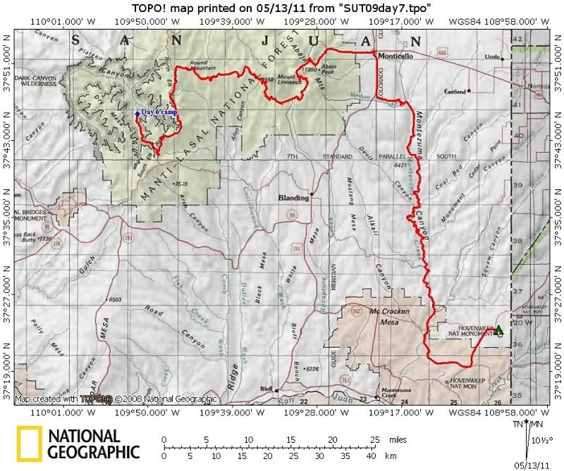
Day Seven
Cold and crisp after the previous evenings rain dawned day seven of our Southern Utah Traverse. Curled up against the cold in the back seat made
for a great nights sleep. The Jeep didn't want to run smooth at first when starting up to leave but for only a minute, then it ran fine. Only hint of
worry of any kind during the traverse.

On the way out while distracted by the scenic beauty of the canyon I failed to see a particularly deep ditch like wash cut that had grabbed our rear
bumpers on the way in, so hitting it at regular speed before I could react caused quite a bounce and did a number to my poor ARB Bull Bar. Upon re-
gaining the trail head on top we made a futile attempt at pulling out the bumper.

With one member of the group gone we re-evaluated our plans. Putting our heads together we decided to drive through the Abajo mountains
(or Blue Mountains as they have always been known locally) and go on in to Monticello, choosing the most interesting looking route to get there.

Big Notch and the Abajo Mountains.

Lime Creek Road.

Reef of Rocks.

Maverick Point overlook.
View out the window driving along the flanks of the Abajo, the Bears Ears just visible on the distant horizon at far left.

Fall color in the mountains.

At altitude near Cooley Pass.
Hunting parties were everywhere, every turn out and meadow had a respectable hunting camp and hunters in orange passed us frequently as we
wound our way over the mountains.

Naturally this is when we got to see Deer during the traverse.
Soon we were gassed up in Monticello and I returned Jan's kindness of a few nights before at a local restaurant for lunch, then we decided on taking Montezuma
Canyon towards Hovenweep National Monument stopping at every Anasazi sight we could spot along the way. Spotted quite a few so we stopped often.

Alcove with scattered remnants of the past.

Detail shot at the Bradford Canyon site.

Three Kiva Pueblo.
At the bottom of Montezuma Canyon Jan and I parted ways, He made for the Colorado Border and on to a friends place to get a chance to clean up before
his next expedition started, while I continued on to Hovenweep making one more stop at some road side petroglyphs spotted along the way.

Arriving at Hovenweep just after a thunder storm and with the one I had just driven through threatening, I set up a tent in the campground then set off to hike
around Little Ruin Canyon photographing the ruins. My best results came as the oncoming thunder storm died and the sun appeared below it just before setting.

Hovenweep Castle by xjblue, on Flickr

Sunset panoramic featuring the quickly dissipated remains of the storm,

large size.

Last camp, Sleeping Ute Mountain dominates the horizon east of Hovenweep.
Finished the hike just before dark then cooked one last freeze dried meal via the jet boil and slept really well in spite of being out of the relative wilderness
for the first time in a week and surrounded by the semi civilized environs of a 1/2 full campground albeit a fairly remote one. Day seven was done and the
Colorado border, final goal of the traverse, was very close.
Cold and crisp after the previous evenings rain dawned day seven of our Southern Utah Traverse. Curled up against the cold in the back seat made
for a great nights sleep. The Jeep didn't want to run smooth at first when starting up to leave but for only a minute, then it ran fine. Only hint of
worry of any kind during the traverse.
On the way out while distracted by the scenic beauty of the canyon I failed to see a particularly deep ditch like wash cut that had grabbed our rear
bumpers on the way in, so hitting it at regular speed before I could react caused quite a bounce and did a number to my poor ARB Bull Bar. Upon re-
gaining the trail head on top we made a futile attempt at pulling out the bumper.
With one member of the group gone we re-evaluated our plans. Putting our heads together we decided to drive through the Abajo mountains
(or Blue Mountains as they have always been known locally) and go on in to Monticello, choosing the most interesting looking route to get there.
Big Notch and the Abajo Mountains.
Lime Creek Road.
Reef of Rocks.
Maverick Point overlook.
View out the window driving along the flanks of the Abajo, the Bears Ears just visible on the distant horizon at far left.
Fall color in the mountains.
At altitude near Cooley Pass.
Hunting parties were everywhere, every turn out and meadow had a respectable hunting camp and hunters in orange passed us frequently as we
wound our way over the mountains.
Naturally this is when we got to see Deer during the traverse.
Soon we were gassed up in Monticello and I returned Jan's kindness of a few nights before at a local restaurant for lunch, then we decided on taking Montezuma
Canyon towards Hovenweep National Monument stopping at every Anasazi sight we could spot along the way. Spotted quite a few so we stopped often.
Alcove with scattered remnants of the past.
Detail shot at the Bradford Canyon site.
Three Kiva Pueblo.
At the bottom of Montezuma Canyon Jan and I parted ways, He made for the Colorado Border and on to a friends place to get a chance to clean up before
his next expedition started, while I continued on to Hovenweep making one more stop at some road side petroglyphs spotted along the way.
Arriving at Hovenweep just after a thunder storm and with the one I had just driven through threatening, I set up a tent in the campground then set off to hike
around Little Ruin Canyon photographing the ruins. My best results came as the oncoming thunder storm died and the sun appeared below it just before setting.
Hovenweep Castle by xjblue, on Flickr
Sunset panoramic featuring the quickly dissipated remains of the storm,
large size.
Last camp, Sleeping Ute Mountain dominates the horizon east of Hovenweep.
Finished the hike just before dark then cooked one last freeze dried meal via the jet boil and slept really well in spite of being out of the relative wilderness
for the first time in a week and surrounded by the semi civilized environs of a 1/2 full campground albeit a fairly remote one. Day seven was done and the
Colorado border, final goal of the traverse, was very close.
Last edited:
xjblue
Observer
Day Eight
The excellent construction at Hovenweep exemplifies the Mesa Verde influence, particularly that of prolific tower building commonly around heads
of canyons and near springs or seeps. It is thought that many of the Hovenweep structures were held in significance to the culture, not all that
different than how we regard our large and important buildings today. The questions of what the towers and castles of Hovenweep were specifically
used for will keep those students of their pre-history occupied for some time.
I got up early to re-hike the Little Ruin Canyon loop to catch morning light on the ruins before breakfast.

Boulder house ruin is pretty crazy.

Twin towers was a personal favorite.

Example of the quality of construction at these ruins.

Interestingly perched Stronghold House.

Hovenweep Castle.
After breakfast and casually packing up I left the park headed for it's outliers in Colorado and other nearby Canyons of the Ancients sites. I found the
boarder between Utah and Colorado to be most appropriately signed for officially finishing our 2009 Southern Utah Traverse.

0909SUT-D8_15 by xjblue, on Flickr
References
4WD Adventures Utah - Peter Massey and Jeanne Wilson
Hiking and Exploring the Paria River - 4th Edition - Michael R. Kelsey
Hiking and Exploring Utah's Henry Mountains and Robbers Roost - Michael Kelsey
Non Technical Canyon Hiking Guide to the Colorado Plateau - 5th Edition - Michael R. Kelsey
Canyoneering 3 Loop Hikes in Utah's Escalante - Steve Allen
Hiking Grand Staircase-Escalante & the Glen Canyon Region - Ron Adkison
Hiking Utah's Summits - Paula Huff and Tom Wharton
Utah road and recreation atlas
Nevada road and recreation atlas
Colorado road and recreation atlas
Sinuhexavier Utah Traverse trip report
http://www.expeditionexchange.com/fo...2606#post22606
Parunuweap Canyon Run trip report
http://www.expeditionutah.com/forum/showthread.php?t=523&highlight=barracks+trail
EU.com Utah Traverse 2009 Beta Planning Thread
http://www.expeditionutah.com/forum/showthread.php?t=346
Utah Traverse Dates thread (09')
http://www.expeditionutah.com/forum/showthread.php?t=651
Sept 4-13 Southern Utah Traverse trip planning thread (09')
http://www.expeditionutah.com/forum/showthread.php?t=838
2011 Southern Utah Traverse trip planning thread.
http://www.expeditionutah.com/forum/showthread.php?t=1811
Additional photos
Adam's album (GoKracer1)
http://www.fototime.com/ftweb/bin/ft.dll/pictures?userid={2E7BD73C-28F3-4C5F-BE84-947B615A783C}&AlbumId={9FEA17AB-D009-4925-8175-38611D5B59B2}&GroupId={2663F41D-92A6-476A-B2DD-619E18F9E3A3}&nt=a
Jan's album
(link pending)
My album
(link pending)
The excellent construction at Hovenweep exemplifies the Mesa Verde influence, particularly that of prolific tower building commonly around heads
of canyons and near springs or seeps. It is thought that many of the Hovenweep structures were held in significance to the culture, not all that
different than how we regard our large and important buildings today. The questions of what the towers and castles of Hovenweep were specifically
used for will keep those students of their pre-history occupied for some time.
I got up early to re-hike the Little Ruin Canyon loop to catch morning light on the ruins before breakfast.
Boulder house ruin is pretty crazy.
Twin towers was a personal favorite.
Example of the quality of construction at these ruins.
Interestingly perched Stronghold House.
Hovenweep Castle.
After breakfast and casually packing up I left the park headed for it's outliers in Colorado and other nearby Canyons of the Ancients sites. I found the
boarder between Utah and Colorado to be most appropriately signed for officially finishing our 2009 Southern Utah Traverse.
0909SUT-D8_15 by xjblue, on Flickr
References
4WD Adventures Utah - Peter Massey and Jeanne Wilson
Hiking and Exploring the Paria River - 4th Edition - Michael R. Kelsey
Hiking and Exploring Utah's Henry Mountains and Robbers Roost - Michael Kelsey
Non Technical Canyon Hiking Guide to the Colorado Plateau - 5th Edition - Michael R. Kelsey
Canyoneering 3 Loop Hikes in Utah's Escalante - Steve Allen
Hiking Grand Staircase-Escalante & the Glen Canyon Region - Ron Adkison
Hiking Utah's Summits - Paula Huff and Tom Wharton
Utah road and recreation atlas
Nevada road and recreation atlas
Colorado road and recreation atlas
Sinuhexavier Utah Traverse trip report
http://www.expeditionexchange.com/fo...2606#post22606
Parunuweap Canyon Run trip report
http://www.expeditionutah.com/forum/showthread.php?t=523&highlight=barracks+trail
EU.com Utah Traverse 2009 Beta Planning Thread
http://www.expeditionutah.com/forum/showthread.php?t=346
Utah Traverse Dates thread (09')
http://www.expeditionutah.com/forum/showthread.php?t=651
Sept 4-13 Southern Utah Traverse trip planning thread (09')
http://www.expeditionutah.com/forum/showthread.php?t=838
2011 Southern Utah Traverse trip planning thread.
http://www.expeditionutah.com/forum/showthread.php?t=1811
Additional photos
Adam's album (GoKracer1)
http://www.fototime.com/ftweb/bin/ft.dll/pictures?userid={2E7BD73C-28F3-4C5F-BE84-947B615A783C}&AlbumId={9FEA17AB-D009-4925-8175-38611D5B59B2}&GroupId={2663F41D-92A6-476A-B2DD-619E18F9E3A3}&nt=a
Jan's album
(link pending)
My album
(link pending)
Last edited:
i really appreciate this report aswell; planning a trip this summer and want to do escalante. thanks so much. Many people seem to think that posting routes and spots to stop are not good but I disagree; if a special stop may help a fellow traveler with some time or a side trip it makes this website all the more worth it. thanks again
cruiseroutfit
Well-known member
Thanks again for getting the ball rolling on this Kurt, remembering that first meeting we had, and how it should be your turn to do this one, soon I hope!
I'm still hoping for a September trip. Busy year

sinuhexavier
Explorer
Great trip report as well as the photo's... But are the maps really necessary?
All anyone needs to know is where Nevada stops and Colorado begins... Here is the link to my original post. That last paragraph on the first post is part of the spirit of the traverse.
"I don't have GPS coords or a map so please don't ask, it's all there in the pictures, fill up your tank and let your mind wander while your curiosities guide you, it worked for me and it will work for you."
xpdishn
Adventurer
Great trip report as well as the photo's... But are the maps really necessary?
All anyone needs to know is where Nevada stops and Colorado begins... Here is the link to my original post. That last paragraph on the first post is part of the spirit of the traverse.
"I don't have GPS coords or a map so please don't ask, it's all there in the pictures, fill up your tank and let your mind wander while your curiosities guide you, it worked for me and it will work for you."
The comment highlighted above is a negative comment that is not necessary at all. There have been discussions about why people don't post trips as much as they use to. Your comment is one reason. Your opinion is your opinion and should not be used to denigrate a very fine post. Is the posting of maps a no-no in the Rules of post trip reports?
If one has never been on a particular road, following someone else's route is not exploring?
I see that a highjacking has just occurred and I apoligize to xjblue. Rant over.
Gary
sinuhexavier
Explorer
The comment highlighted above is a negative comment that is not necessary at all. There have been discussions about why people don't post trips as much as they use to. Your comment is one reason. Your opinion is your opinion and should not be used to denigrate a very fine post. Is the posting of maps a no-no in the Rules of post trip reports?
If one has never been on a particular road, following someone else's route is not exploring?
I see that a highjacking has just occurred and I apoligize to xjblue. Rant over.
Gary
It's not a comment, it's a question. A valid one I think.
I don't think my question takes anything away from this great trip report. I appreciate the style in which it was done with only 3 vehicles, small foot print at campsites and the overall feel of the trip.
My concern is that these maps highlight some areas that are very close to being closed by the BLM. There is no need to publish these locations on the internet where some that don't travel in the same style may tramp.
If you can't appreciate this point of view, I'm sincerely sorry.
My opinion on maps and GPS coords. is well known and one I am willing to defend. Yes, it IS my opinion and it's yours that it's a negative one.
xjblue
Observer
Thank you,Great stuff, I too was just in Escalante, UT last week checking out GSENM and such. I work for the BLM so it was a great opportunity- hope you all enjoyed!
Thank you, yes just started using NG, so far so good.Great trip report. Really wets the appetite for our traverse come Oct. I see you also use NG TOPO, we really like it. Thanks for taking the time to post this.
Gary
Your welcome, thank you.i really appreciate this report aswell; planning a trip this summer and want to do escalante. thanks so much. Many people seem to think that posting routes and spots to stop are not good but I disagree; if a special stop may help a fellow traveler with some time or a side trip it makes this website all the more worth it. thanks again
Thank you.Someday!
Nicely done amigo!
:drool:
If anyone deserves it...!I'm still hoping for a September trip. Busy year
Thank you, I've pondered your question all day. I can appreciate your take on the spirit of the trip and that really came through in your report, the few spectacular photos and tidbits of information, perhaps all the more inspiring to seek for those couple spots I didn't recognize than if you had spelled it all out.Great trip report as well as the photo's... But are the maps really necessary?
All anyone needs to know is where Nevada stops and Colorado begins... Here is the link to my original post. That last paragraph on the first post is part of the spirit of the traverse.
"I don't have GPS coords or a map so please don't ask, it's all there in the pictures, fill up your tank and let your mind wander while your curiosities guide you, it worked for me and it will work for you."
At first I thought reactively of the question as "recieving a little flak" , but it did have me thinking about it all day, so change that to "thought provoking".
I originally planned to have maps or GPS files avialable when posting here, at the time, shortly after the trip, I recall it being suggested by an individual to do so. Perhaps things have changed since then is what I now gather from some of the others responses? But the suggestion was such that the primary reason for my delaying this post here was I hadn't yet sat down and figured my mapping stuff out, till recently. Being my first time posting maps all the feedback is welcome.
I think this was all highlighted by something the BLM Ranger said to me as we exited one of those areas of concern, as I recall he said something to the effect of "I'm glad to see you guys out exploring the history and enjoying the area rather than just coming out here to be tearing things up." I had two reactions, first one was we noticed as I recall no blatent evidence of such bad behavior in the area we just exited, my impression rather is it felt very seldom traveled and most un-threatened. And two, clearly he had however dealt with some troublemakers, no doubt.
My motivation is to inspire the like minded to get involved in these areas,
while inspiring more people to become like minded, and treat such places properly.
But the quandry is, to raise awareness you are raising awareness,
and possibly changing seldom traveled to a little less so, then factoring an about to close status, adding complication to a complicated question.
I admit a part of me wants to never report on how great anything in any part of Utah is in any way, nothing to see here, move along...
Similar threads
- Replies
- 0
- Views
- 756
- Replies
- 0
- Views
- 579
- Replies
- 0
- Views
- 627