Ideas for a new dedicated GPS for overlanding

Outono

Well-known member
I've spent the past year trying different GPS units and software and i've come away feeling like nobody has really nailed it for car campers and overlanders.

To me, software solutions lack the ease of use and feature sets required for vehicle travel, especially if you're part of a group. Hardware solutions, of which there is really only one (Garmin), are expensive and hardly live up to the expectations one would have for such an investment.

So im curious what you all think is missing in the market. How can these hardware and software solutions be better? Everybody hates a subscription, but what would make paying for one worthwhile for you?
 

pluton

Adventurer
I assume that the main purpose the GPS equipment is showing where you are on a map and maybe displaying a route.
$800 to $1400 worth of Garmin stuff or $40/year for 20 years of Gaia. If you include the purchase of an iPad Mini 6 along with Gaia, the cost is approximately a wash. Gaia will probably fold or go bad long before 10 years, let alone 20 years. The Garmin units will probably start to fail in about 10 years like my original Montana 600 series did. All the current solutions are temporary....pick the least annoying system and don't over invest in it!
 

Peter_n_Margaret

Adventurer
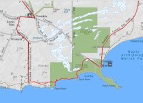
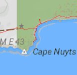
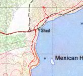
I have been operating a PC version for over 20 years. In the vehicle I am now running an android version on a 10" tablet and love it.
Add your own raster maps.
Cheers,
Peter
OKA196 motorhome
 

Attachments

  • Track 1.jpg
    Track 1.jpg
    390.3 KB · Views: 18
  • Track 2.jpg
    Track 2.jpg
    137.2 KB · Views: 16
  • Track 3.jpg
    Track 3.jpg
    457.7 KB · Views: 16

Outono

Well-known member
I assume that the main purpose the GPS equipment is showing where you are on a map and maybe displaying a route.
$800 to $1400 worth of Garmin stuff or $40/year for 20 years of Gaia. If you include the purchase of an iPad Mini 6 along with Gaia, the cost is approximately a wash. Gaia will probably fold or go bad long before 10 years, let alone 20 years. The Garmin units will probably start to fail in about 10 years like my original Montana 600 series did. All the current solutions are temporary....pick the least annoying system and don't over invest in it!
Ya, the math makes sense. I suppose the real question is should your nav unit do more than just help you navigate? We're starting to see this with Garmin integrating the InReach, MURS radio, and offering other inputs (audio breakout, for example). I suppose unifying all of the crap you mount to the front / top of your dash is a great idea since i've seen some rigs just covered in discrete devices.
iPads offer a lot more utility, but lack the ruggedness required for real use outdoors.

If the goal is to just have a nav and nothing more then the existing solutions are fine. To me, and I assume there are others out there, the nav should offer more than simple directions.
 

Joe917

Explorer
We ran a 10" tablet all over the Americas, using open street maps and maps.me,
We started off running it with a garmin gps until we found the garmin maps were less accurate and the routing often was poor.
We ditched the Garmin gps and replaced it with an In Reach (yes also Garmin). The InReach was primarily for sending texts when in remote areas. The In Reach mapping worked seamlessly with the tablet.
I highly recommend an Android tablet with software of your choice.
I have an ipad Pro from work and just hate the thing.
 

Outono

Well-known member
We ran a 10" tablet all over the Americas, using open street maps and maps.me,
We started off running it with a garmin gps until we found the garmin maps were less accurate and the routing often was poor.
We ditched the Garmin gps and replaced it with an In Reach (yes also Garmin). The InReach was primarily for sending texts when in remote areas. The In Reach mapping worked seamlessly with the tablet.
I highly recommend an Android tablet with software of your choice.
I have an ipad Pro from work and just hate the thing.
Are you using the nav for traveling alone or are you in a group? I find most solutions lack solid group options and are made for the singular user.

I have an Android and I agree, its better for navigation than iPads are. Better options for add-on apps too.

As for Garmin, kinda wild they're the only real hardware vendor in this space. Magellan, HEMA, and others are essentially dead and haven't offered anything modern in years.
 

Joe917

Explorer
Solo, you are looking for something that can display the location of a couple ov vehicles at once?
 

smbisig

Adventurer
Another vote for iPad Mini + Gaia. I haven't had any problems with this setup. I also keep basic maps loaded on my iPhone for a backup and of course, also carry paper maps/books as an additional backup.
 

Stroked 550

Adventurer
I have been running the locus app on my android phone and tablet for roughly 10 years
What I like about it is you only download one map per state. It has worked without a glitch for all these years both on my dual sport and Jeep
 

alanymarce

Well-known member
We've run Garmin units for decades and they do what we want (know where we are, download GPX files, not used for "turn by turn" navigation). We have maps on laptop and iPad of general reference, and also use the time-honoured approach of asking the way from locals, which works well everywhere except Brazil. The only thing which would help us in terms of a development would be bluetooth connection to the laptop/iPad.
 

Backroad Explorer

Adventurer
Dual XGPS150A or XGPS160. Both are Bluetooth capable and
FAA approved for use in aircraft. Very accurate & holds a signal even when
placed above the visor too keep cool & out of the sun.
 

alanymarce

Well-known member
Dual XGPS150A or XGPS160. Both are Bluetooth capable and
FAA approved for use in aircraft. Very accurate & holds a signal even when
placed above the visor too keep cool & out of the sun.
Looks good. I had a quick look at the Dual website and couldn't find whether one can download the GPX files. Do you know?
 

Backroad Explorer

Adventurer
That would depend on your Mapping software.
I use either on X or Gaia and Scenic Maps.
Dual GPS is a Receiver only it works with most apps.
Just Bluetooth to your Device and away you go.
 

Forum statistics

Threads
188,060
Messages
2,901,699
Members
229,411
Latest member
IvaBru
Top