Cody1771
Explorer
to start off I love this app. doing what I do (working for the Coast Guard) its really neat to be able to mark umm... important locations.... (such as good fishing spots and hot springs) for future use. I originally used the maps program it came with but not being meant for navigation it was pretty useless. so I was on the hunt for a new app.
Many of you probably have no use for a navigation program as this is an over landing group. I do a lot of boating, fishing, and such and I think some of you will feel the same way to. if you spend any time on the water it is useful.
On a bit of a side note if you where wanting to use this as a chart replacement (only legal if you have the paper charts on board) it would be better suited to the IPAD for the larger screen.
This App is currently $40 in the app store so its not cheap.
But, like I said it is has FULL set of all charts for the entire BC coast, how much would that cost you on any other app or paper? as well as constant updating and chart corrections. they also offer charts for various other places of the world, ranging in price from $1 to $40 depending on the intensity of the charts.


this is the opening screen you get when you start the app. the first is the loading screen then you get a basic disclaimer. it is not legal to use electronic charts as your primary chart set in Canada at this date UNLESS you have a completely separate backup system. however it is legal to use them if you have a full set of updated paper charts on hand.
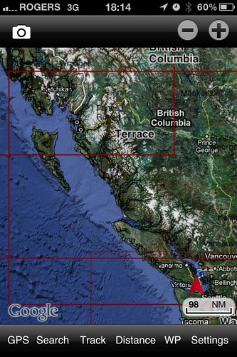
this is what the app looks like fully zoomed out on our coast, with the Google map overlay activated. the red arrow is your current location. you can turn the Google map overlay off if you want, but I think it looks better with it on.
once you start zooming in, the ground terrain remains the satellite imagery from Google but the water turns into proper charts.

if you have Google off the ground looks as it does in a chart, the only details that are shown are those directly on shore of the water, its very limited.
Many of you probably have no use for a navigation program as this is an over landing group. I do a lot of boating, fishing, and such and I think some of you will feel the same way to. if you spend any time on the water it is useful.
On a bit of a side note if you where wanting to use this as a chart replacement (only legal if you have the paper charts on board) it would be better suited to the IPAD for the larger screen.
This App is currently $40 in the app store so its not cheap.
But, like I said it is has FULL set of all charts for the entire BC coast, how much would that cost you on any other app or paper? as well as constant updating and chart corrections. they also offer charts for various other places of the world, ranging in price from $1 to $40 depending on the intensity of the charts.
this is the opening screen you get when you start the app. the first is the loading screen then you get a basic disclaimer. it is not legal to use electronic charts as your primary chart set in Canada at this date UNLESS you have a completely separate backup system. however it is legal to use them if you have a full set of updated paper charts on hand.
this is what the app looks like fully zoomed out on our coast, with the Google map overlay activated. the red arrow is your current location. you can turn the Google map overlay off if you want, but I think it looks better with it on.
once you start zooming in, the ground terrain remains the satellite imagery from Google but the water turns into proper charts.
if you have Google off the ground looks as it does in a chart, the only details that are shown are those directly on shore of the water, its very limited.


