biotect
Designer
CONTINUED FROM PREVIOUS POST
********************************************
In terms of rainfall, there is no question that the Lake Titicaca basin as a whole is one of the drier areas in Peru. Not quite as dry as the desert on Peru’s coast, but dry enough. Lake Titicaca is not quite as dry as the far southwestern corner of Bolivia, but it is still located in a region that is semi-arid. It's hard to find a map of precipitation that ignores national boundaries; most maps of precipitation cover either Peru or Bolivia, but not both. Only the following map provides a broader picture of rainfall for the Altiplano as a whole:
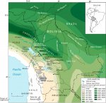
But within the overall context of the semi-arid Titicaca basin, the lake itself and its immediate surrounding coastline is actually quite wet. Here are two maps of annual average rainfall, one for the basin as a whole, and the other zoomed-in on Lake Titicaca:

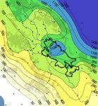
These maps suggest that Lake Titicaca in particular receives 800 – 1000 mm of rainfall annually, a comparatively wet oasis surrounded by an otherwise semi-arid, high-altitude plateau. The southern end of the basin receives only 300 – 350 mm of rainfall. Perhaps because the lake is so high up, and loses so much water through evapotranspiration, it actually generates its own rainfall?
The following map paints the same picture of precipitation for the basin as a whole:

The seasonal climatological consequences are interesting, because contrary to what one might expect, summer is the rainy season on Lake Titicaca, not winter, as would be typical for a Mediterranean climate. In the following map the original legend in Spanish was difficult to read, so I rewrote it, and provided what (I hope) are resasonably accurate English translations (?):
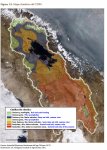
This map describes the area immediately around Lake Titicaca as either “Rainy and cold, summer rains”, or “Semi-rainy and cold, summer rains”.
The images of Lake Titicaca during the dry season, hillsides covered with well-tended terraces, will probably remind those who have travelled a bit of the drier regions of the Mediterranean. When these dry-brown images contrast with other images of the same terraces lush and green during the wet season, one might conclude that Lake Titicaca’s climate must be Mediterranean. But it is actually the exact opposite, with rain falling most heavily during the warmest months. The images of dry, parched hills with plenty of sunshine were taken during the winter, not the summer.
Vineyards flourish in Mediterranean climates, and there is viticulture in Peru, but in the coastal plain around the city of Pisco, not lake Titicaca. And Bolivian wine production is negligible – see http://www.wine-searcher.com/regions-peru and http://www.wine-searcher.com/regions-bolivia . The Köppen climate classification system categorizes most of the Altiplano as either BWk (BW – arid desert climate; k – at least one month with an average temperature below 0 °C), or BSk (BS – semi-arid steppe clima; k, the same). For Csa/Csb Mediterranean climates, where viticulture flourishes, one has to go much further south to Chile – see https://en.wikipedia.org/wiki/Köppen_climate_classification . However, lake Titicaca specifically seems to classify as CWb: C – temperate; W – dry winter; b – the warmest month averaging below 22 °C, but with at least four months averaging above 10 °C. Comparatively speaking, Lake Titicaca seems to have a climate similar to many high-altitude areas in Africa (for instance, the Ethiopian highlands), and so too, similar to the climate of the cooler, more arid regions of northern Nepal, northern India, and southern Tibet.
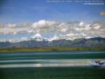
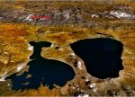
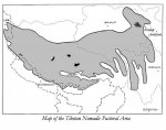
There is no other lake in the world quite like Titicaca, not even in Tibet. Tibet is too far north and the plateau too cold to support the kind of intensive terraced agriculture possible on Lake Titicaca. For the most part Tibet’s pre-modern lifeway was nomadic pastoralism: raising livestock like sheep, cattle, goats, horses, and yaks. In Tibet there is limited farming of barley, wheat, buckwheat, and rye in some of the lower-altitude valleys, but nothing like the intensive agriculture that occurred in the Lake Titicaca basin – see https://en.wikipedia.org/wiki/Economy_of_Tibet and http://www.case.edu/affil/tibet/documents/TheWorldofTibetanNomadsSept14.pdf :
Lake Titicaca is thought to be the area where the potato, the tomato, the common pepper, and lima beans were first domesticated – see http://www.roughguides.com/destinations/south-america/peru/arequipa-and-lake-titicaca/lake-titicaca/ and http://www.fao.org/potato-2008/en/potato/origins.html . Furthermore, native Indians in the Andes have continued growing at least 30 additional domesticated vegetables and fruits that are relatively unknown to the wider world: tubers like achira, ahipa, arracacha, maca, mashua, mauka, oca, ulluco, and yacon; grains like kaniwa, kiwicha, and quionoa; legumes like basul, nunas, and tarwi; various kinds of peppers and squash; fruits like capuli cherries, cherimoya, goldenberry, highland papayas, lucuma, naranjilla, pacay, passionfruits, pepino, and tamarillo; and various kinds of nuts. See Lost Crops of the Incas, at http://www.nap.edu/openbook.php?record_id=1398&page=1 , http://www.nap.edu/catalog/1398/lost-crops-of-the-incas-little-known-plants-of-the , and http://www.nap.edu/openbook.php?record_id=1398&page=401. There is no equivalent history of crop domestication in Tibet.
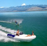
In short, Lake Titicaca is a natural wonder as well as a historical treasure, and utterly unique. It is packed with Andean ruins, and huge RAMSAR marshes fed by long, flat rivers to explore, where a hydro-jet RIB would be in its own element, and would have spectacular vistas of a nearby mountain range called the "Cordillera Reale":
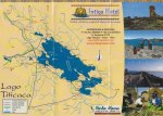

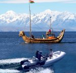
The above visual "jokes" of the TerraLiner's hydro-jet RIB whizzing by some ancient Titicaca reed-boats are all in good fun. Sure, I deliberately tried to push some politically incorrect buttons with these photo-collages. But personally speaking, I detest boaters who race through narrow waterways at top speed, whether it’s canals in Venice or South Florida, or riverine passageways through marshes. High-speed boating does tremendous damage to the fragile banks of lakes and rivers, and in South Florida and Venice the speed-limits along the canals are strict. Many residential communities with houses on canals in South Florida have completely banned Jetskis, because their drivers tend to be irresponsible young males under age 25, who will race through canals creating enormous wakes and terrific noise.
On the other hand, it's worth observing that Lake Titicaca already has many such ancient/modern contrasts. For instance, hydrofoils have been running across the lake for decades, and most of the Indians living on the lake now use outboard motors to power their boats.
For the TerraLiner, there would also be kayaking and sailing with a Weta trimaran, a trimaran that one can collapse to a relatively compact size. Both kayaking and small-boat sailing are activities that are wonderful to do on lakes, and kayaking is also a riverine activity. Oddly enough, although the ancient Incas sailed Lake Titicaca for millennia in boats made out of reeds, there do not seem to be too many modern sailboats on the lake -- see https://en.wikipedia.org/wiki/Reed_boat , https://en.wikipedia.org/wiki/Balsa_(ship) , and https://en.wikipedia.org/wiki/Totora_(plant) . La Paz is a city of millions (metro area) just a few hours away, so it's a bit surprising that a marina to accommodate sailboats has not yet been built on the lake -- see https://en.wikipedia.org/wiki/La_Paz . Sure, Bolivia is a poor country, but such countries always have elites with some money, of the kind that could afford sailboats. The following are the only two videos that I could find of pleasure-boat sailing on Lake Titicaca:
[video=vimeo;125009019]https://vimeo.com/125009019 [/video] .. [video=youtube;SEVAoZsJXWs]https://www.youtube.com/watch?v=SEVAoZsJXWs [/video]
These videos are wonderful, because they capture “viscerally” what it’s like to experience Lake Titicaca as a body of water. The second-to-last video demonstrates that there is at least one modern sailboat cruising Lake Titicaca. But granted, average windspeeds on Lake Titicaca are not impressive. Even at 80 m altitude, and even during the winter and spring, windspeeds average 5- 6 m/s or 11 – 13 mph on the Peruvian side of the lake. During the summer the windspeed is slower, in the 4 – 5 m/s range.
Notice in the first video (skip ahead 4 minutes in) that the guy does quite a bit of rowing, even though the climate is cold and often raining. Because of this, one might surmise that it’s winter on the lake. However, I strongly suspect that this couple decided to explore the lake during the summer, i.e. November through March. As noted above, on lake Titicaca the rainy season happens during the summer, not the winter. So sailing on Lake Titicaca would actually be best done during the winter and spring, from June through November, when the lake is both sunnier and there’s more wind. On the positive side, the lack of strong wind on Lake Titicaca means that the TerraLiner would probably be able to keep its side pergola awnings open the whole time, taking advantage of Lake Titicaca's phenomenal DNI -- see http://solargis.info/doc/free-solar-radiation-maps-DNI :

Note the scales on these maps: the scale tops out at 3000 (Peru), and at 3600 (Bolivia). So dark red on these maps means something fundamentally different than dark red on other maps in this series. For better or worse the map-makers did not use the same color scale on all maps. So even if Lake Titicaca is surrounded by orange on the Bolivian map, that corresponds to 2800 kWh/m[SUP]2 [/SUP]. As we already saw in post #2328 at http://www.expeditionportal.com/for...w-6x6-Hybrid-Drivetrain?p=2008589#post2008589 , the scale on the map for Europe only goes as high as 2400, and the scale on the map for Ecuador only goes as high as 1800. So 2800 - 3000 kWh/m[SUP]2 [/SUP]which seems the norm on the shores surrounding Lake Titicaca is quite literally off the charts. There is no DNI in Europe even remotely like this, not even in Spain. This is some of the highest DNI in the world. Only further south in the basin, towards southwestern Bolivia, does DNI get even more extreme, topping 3600 Wh/m[SUP]2[/SUP]. So on Lake Titicaca, too, it's very possible that the TerraLiner will be able to operate all camper systems on solar alone when boondocking. A/C won't be needed, only heat at night.
At first I thought that summer would be the best time to visit Lake Titicaca, because presumably that’s when the sun will be strongest. Titicaca is below the equator, so the height of summer is January/February. But once one realizes that summer is the rainy season, fall, winter, or spring seem like the better seasons to glamp on the lake.
But it’s much colder on Lake Titicaca in the winter, right?
Well, cold here is all relative. Lake Titicaca is well north of the Tropic of Capricorn, about as near to the Equator as Honduras, Senegal, Thailand, and Vietnam. Lake Titicaca lies at 12,500 feet above sea level, to be sure, but as near as I can tell, this means that it has a climate akin to what Europeans and North Americans might consider early spring or late fall. Just all year round, like Hacienda Zuleta.
During the winter months the temperature on the lake does dip, from summer monthly averages of 10.7 degrees Celsius during November, January, and February (51 degrees Fahrenheit), to 6.2 C for June, 5.7 C for July, and 7.4 C for August (42 – 45 degrees Fahrenheit) -- see https://en.wikipedia.org/wiki/Lake_Titicaca . But monthly average temperatures do not truly capture how we experience climate. For instance, it’s always much colder at night, especially on a semiarid, high-altitude plateau like the Altiplano. Even during the winter, afternoons on Lake Titicaca are said to be warm, and there is not much difference between the average highs during the summer and the winter on the lake. If anything, the peak months for high temperatures are October and November – after the winter, but before the summer rainy season. The big difference between summer and winter is their average lows: during the winter temperatures can drop well below freezing. Whereas from October to April the lowest temperatures seems to be always above freezing. Furthermore, because of the moderating effect of the lake, the immediately surrounding coastline is likely to experience many more months free of frost and drought than the rest of the Basin. Lake Titicaca is such a deep lake that it acts like a huge heat sink, creating a local microclimate that is much more conducive to intensive agriculture.
Here it’s also worth noting just how little the average temperature on the lake changes, in comparison to the surrounding mountains, or the Peruvian coast. The following is a YouTube video that shows a one-year cycle in Peru for both rainfall and temperature:
So my best guess is that the ideal time for the TerraLiner to visit Lake Titicaca would be September through December. The heavy rainfall of January and February will not have arrived yet, so the TerraLiner’s solar arrays will not be contending with much cloud cover. Nights will be less cold, and frosts rare. And there will still be plenty of wind on the lake, if one hopes to do some sailing.
********************************************
I discussed Lake Titicaca in some degree of depth, because I wanted to demonstrate just how much fun a "surf glamper" like the TerraLiner could have on such a lake. I've actually written much more about Lake Titicaca, and downloaded hundreds of images. Perhaps once we get a multi-thread TerraLiner "subcategory" going, as recommended by Libransser, I will post at length about the lake, with lots of images.
The resort town of Copacabana, for instance, seems very beautiful, and during the winter the distance across the lake is so large that the sun appears to set on the water, as if the lake were an ocean. The Cordillera Reale (the "Royal" Mountain Range) is truly spectacular, especially as seen from the southeast corner of the north basin, and the eastern shore of the south basin. The Isla del Sol is stupdenously beautiful (at least in photographs), and the whole lake seems to be circled by excellent, paved roads. La Paz is only a few hours away, so if the TerraLiner were to glamp on the southeastern shore of the north basin, the owners could catch some Opera in Bolivia's capital with the TOAD. Last but not least, even though Titicaca does not seem to have very many contemporary sailboats, it is still very much a "boating lake", packed with motor-boats of all kinds, from modern hydrofoils to old steamers, large cruise-ship-like catamarans to much smaller sight-seeing vessels. Small ports and docks where the TerraLiner's hydro-jet RIB could refuel seem abundant.
One could also imagine the TerraLiner wanting to explore the Great Lakes region of Africa, from the safety and peace of countries like Zambia, Tanzania, and Mozambique. And as already discussed in the thread, the Tibetan plateau is packed with very large lakes to explore. But simultaneously, needless to say, the Tibetan plateau is very mountainous. So if instead one imagines the TerraLiner as more of a "Water Glamper", the requirement to handle mountain roads becomes paramount.
********************************************
CONTINUED IN NEXT POST
.
Last edited:


