Traversing the US (and back)

jessejman

Adventurer
It seems fitting to me that, since I started my trip here, I should end it here as well. I've been around Expo for a few years, basically since I began looking for a family travel vehicle. Eight months ago I began planning a Trans United States offroad route similar to the TAT. That journey is now over. And it was incredible!

There are a few threads here on ExPo that deal with a trail like this or the already established TAT but I decided to plan my own with input from many members on this forum from many different regions. Now that we have some knowledge, though limited, I thought I would make it public.

Here we are leaving our homestead in Chattanooga, TN:
002.JPG
And a little more weather-wisened (Is that a word?) here:
040.jpg


We embarked on our trans-am journey with three specific goals:
1. See this great and beautiful country off the beaten path
2. Grow as a family/team
3. Instill in our children a sense and meaning of adventuring

My goal in posting is not to toot my own horn or tell others how to travel/live but to propose a starting point for what you can do alone or with a family, to show that you can still cross this country out-of-the-way. Other people are doing this and have done it for more than a century, so I know that we are not special in that regard. Not to say we aren't damn proud of what we did; we are and were awestruck by what we found. We have this narrow spectrum of knowledge, of experience, that we want to share with this community in hopes that it will somehow inspire others to get out and explore.


Quick facts:
Miles-
total: 6209
off pavement: 3800 +/-
highest elevation: 13,100 feet
total days out: 57
nights camping: 35
nights at hotel: 0
nights paid for camping: 0
nights spent together in one room/car: 57
meals at restaurants: 3
photos taken: 8000+ / 21gbs
first steps taken: many
fun had: tons

We have a route planning thread already here on the forum so you can get some route info there. Here is another great thread dealing with a Trans United States Trail and another that serves as a route bank. I can send GPX files and KML files but I don't have them posted anywhere at the moment. Here is the general idea:
gooearth+full+route+2.jpg


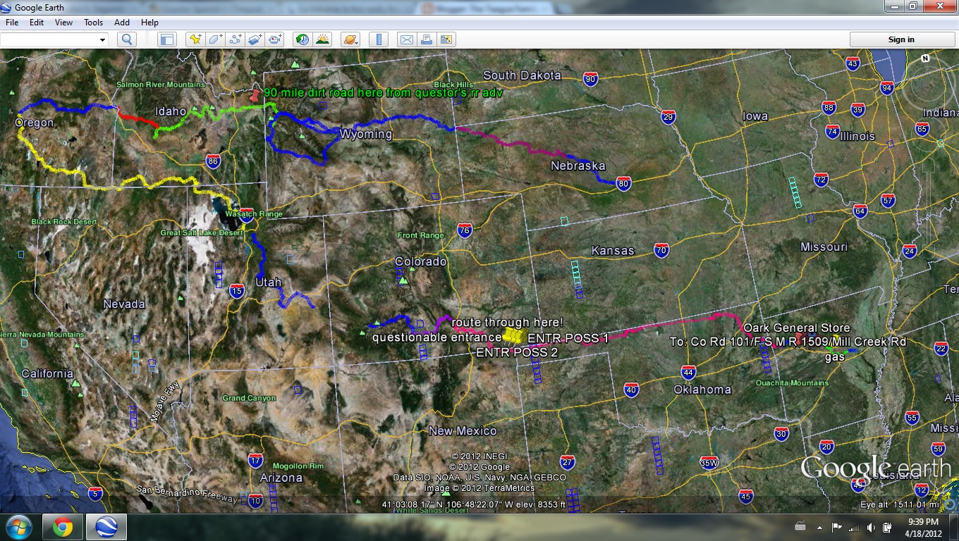
Seeing this photo will give a small glance into how the planning went - waypoints and notes from other travelers trip reports, etc.

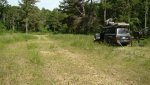
I should also post a quick photo of our vehicle. I love my trucks, as most of us do, but I won't go into much detail here:0324021702.jpg
-'94 Landcruiser with e-lockers
-one storage drawer in rear
-homemade aluminum roof rack
-homemade front bumper with Titan winch
-Featherlite Tent
-CVT awning
-14 gallon homemade onboard water with pump
-homemade rear tire/mtn bike carrier (not pictured)
-dual batteries

The telling of the adventure starts today. More to come but for now I have to go teach a class.
 
Last edited:

jessejman

Adventurer
Days 0-3

June 4th we loaded the truck, said goodbyes to our neighborhood friends (checked for stowaways) and left our home for two months.
001.jpg
003.jpg
Our goal for the day was to get to Memphis quickly.
011.jpg
We traveled mostly paved backroads. The landscape was beautiful but familiar.
014.jpg
Roadside lunch stop.
016.jpg
And some king of the mountain. The kids were doing a good job of entertaining themselves in the car and out.
017.jpg
022.jpg
We slept in inner-city Memphis at a friends work: Advance Memphis, an organization that trains folks from the neighborhood in specific skills and places them in jobs in the area. This was a very urban start of our otherwise very un-urban trip. We actually slept in my friends classroom where he taught a GED class at ten the next morning. The director and staff were so gracious to let us stay there for the night.
038.jpg
Our parking spot inside their courtyard.
042.jpg
Needless to say, we were out the door early and on our way to Arkansas. We needed to make the eastern edge of the Ozark National Forest in order to have a place to camp.
043.jpg
Entering the Ozarks, we finally found gravel!
 

jessejman

Adventurer
Days 0-3

047.jpg

Many thanks to 6string at Central Overland for all his help in planning our route through Ozark NF. His suggestions were spot on and made for an unforgettable trip through the forest on trails that don't even exist on the gazetteers. It was awesome. This was a highlight of our trip and is close enough that we will do it again soon.

048.jpg

Once in the forest we cruised along some nice wide gravel roads that quickly narrowed and became rockier but we still continued to make good progress on these smaller trails. Eventually we made camp down an even more scant trail. The weather was so much cooler and arid than what we had encountered in Memphis and the surrounding area.

055.jpg
062.jpg

Our children jumped at the chance to get out of the car. It had been a long day but what would have to become normal for us. They had done spectacularly well.

082.jpg

Dinner...

085.jpg

and some help setting up the tent.

Day 2
This was our second day off highway and our route continued to get better. It was slower going but we spent the entire morning winding down and then up small valleys and then the afternoon following a stream north through a series of seven or eight water crossings (easy in the summer).

096.jpg

These trails don't see much action by anything other than motos or ATVs. We had to clear a few trees out of the way in places.

099.jpg

092.jpg

My son had his head out the window anytime we were moving. He ended up with a permanent butt-cut part from the wind and we had to continually put sunscreen on him which would the dust would turn into war-stripes.

095.jpg

The view south from White Oak Mountain I think.
 

jessejman

Adventurer
Day 2 continued

100.jpg

The kids were doing great. Sure we stopped a lot for bathroom breaks and diaper changes. We also made it a point to stop wherever we could to swim or cool off in the shade.

104.jpg

I am shamelessly going to let the photos do most of the telling. When they don't explain enough I will jump in.


110.jpg

Working our way down a streambed. This was the most technical track we'd been on so far. Don't worry it gets rougher.

116.jpg

151.jpg

135.jpg

One of the many stream crossings that were mostly dry at this point in the summer. I believe Central Overland has some great spring outings that see some high water marks.

145.jpg

Stopping for lunch and swim/bath.

168.jpg

155.jpg

189.jpg
 
Awesome guys! Thanks for sharing! Did you all sleep in the tent? have a link to the model you used?

Wes (6string) is a stand up guy and I'm glad he shared the routes with you! I can't wait to see more!
 

jessejman

Adventurer
Awesome guys! Thanks for sharing! Did you all sleep in the tent? have a link to the model you used?

We are using a Frontrunner Featherlite tent mainly due to it's comparative lightweight but that comes with some drawbacks. The wife, our 1 year old daughter and I sleep in the tent. Our 6 and 4 year old sleep in the back of the cruiser (seats folded up/down). We did all sleep up there one night and it worked but was very tight.
 

jessejman

Adventurer
mrwizard, we passed just north of you and fell absolutely in love with Idaho. Oh man, crossing the Sawtooths and fording the Middle Boise due to a closed bridge were unforgettable!
 

JakeC

Member
This is great, and I can't wait to see more! I've been considering a trip of this sort as my first overlanding experience.
 

1leglance

2007 Expedition Trophy Champion, Overland Certifie
Looks like a great trip and I am jealous of the 2 month timeframe.
Excellent job getting the kids into the outdoors and putting a lifelong sense of adventure in them.

By the way that is a serious load of wgt on the roof rack from all the gas & water. Did you need 4 fuel cans? Looking forward to your post trip thoughts on what you will do different next time.
 

jessejman

Adventurer
By the way that is a serious load of wgt on the roof rack from all the gas & water. Did you need 4 fuel cans? Looking forward to your post trip thoughts on what you will do different next time.

Fully loaded the truck is heavy - just upwards of 7000lbs. I tried to use the platform we had and make it an Around-the-world truck for five people. No easy task and I'm not sure we're quite there with it. With the four gas and two water cans we would be good for upwards of 500 miles range and around a week without a water resupply.

We never needed the extra water containers. We have 14 gallons underneath where the spare was located. We used that water for everything from drinking to cooking and cleaning. We took very short showers, more just a wipe down really and didn't do that too often. We found that amount would easily last us three days if we were careful. For a long dry-camp the cans would be necessary but I wouldn't take them again. I'd do dromedaries. I continually kept gas in two cans with the other two empty. I never needed the other two. We would have needed them for one section (through the Cimarron Grasslands) but were scared off by an angry property owner.

Ideally I like to stay away from weight on the roof for obvious COG reasons. This became a bigger concern as we moved further west and the tracks became much rougher/off camber. But without pulling a trailer and with 5 of us in one vehicle there was no other option. One day we will be forced into two trucks and the need for anything heavy on the roof will lessen.
 

jessejman

Adventurer
End of Day 2

View attachment 117098
We climbed up a long hill after swimming in the creek at the bottom.
151.jpg

162.jpg

177.jpg
And then descended via a trail that was not on the maps. It was very steep but a dozer had recently been through so it was just rough.
186.jpg

194.jpg
204.jpg
After the long descent we stayed in some bottom land and worked our way through some creekbeds that tested our entry/departure angles. It was very rocky, often navigating by compass direction and working our way through a web of ATV trails that would sometimes become too narrow and we would back track. It was very slow going and was the first of many tests of our navigation skills when we couldn't just follow a straight line on the GPS.

At some point down in the Big Piney valley we hit our first major obstacle. I took a video of a walk through but it didn't turn out very well. The first issue was a diagonal growing tree that would push us over the soft of edge of the trail and leaning us out over a drop off into the creek below. Having past that we would then have to weave through a serious of steep rock steps. At the top step it was obvious that someone had used a backhoe to dig a big hole behind the step, thereby pretty much closing down the road. We were pretty sure we were on public land but not absolutely. This was a trail suggested by 6string and I remember asking myself when the last time he'd been down here was. It was clear to me that no trucks/jeeps had been through here lately. The only tracks were ATV tracks and I remember thinking that even side by sides would have trouble here. I've been driving offroad and riding motorcycles for fifteen years (FJ40, LR series, built D1, f250) but never had my nervousness been so strong; I rolled my FJ40 twice in a day at home, but that of course was not an option here. We were alone and couldn't walk out. The reroute was 60 miles long and would stretch our remaining fuel.

The steps were off-camber towards the creek, any wheel spin would put us over the soft edge and into a long fall. I figured we'd have one go at to get through clean before we slid and things got nasty. My wife spotted and we made it up the first step easily, spanning the ATV tracks and with our right side as far to the right as we could get it. No room for error. Made it up the second step dragging the rear as we dropped down before the last four large step. It was all stone but not vertical with a three foot total gain. The backhoe hole was right behind the step. the step wanted to push us off to the right and down the hill. I hit the step with just enough speed, steady on the throttle, no wheel spin (well, we are heavy) and got a nice driver side wheel stand.

This truck is such a beast. It walked through the obstacle and I was impressed. It was definitely the hardest test we'd put it through so far. Only bad thing is that we knocked the muffler repositioning for the last step. My wife was still learning how to spot.
We looked at the GPS and we had less than a mile before hitting a 'road' and we hoped that this would be the worse thing we saw before getting to it.

I'm interested to know if Wes from Central Overland knows this section I'm describing. Maybe he'll chime in. Maybe I'm dramatizing it but it got my adrenaline going. And, of course, the last thing I was thinking was, "Oh let's take some photos of me endangering my kids lives!" Sorry, wish I had them now.
205 - Copy.jpg
Eventually we made it the famous Oark General Store where we were just in time to refuel. The new owners, Brian and Reagan, had taken over the store three days before. This place is a must stop on the Trans America Trail is a pretty well known landmark for travelers. I would guess most of their business comes from us and ADV riders. They are a great younger couple and have started taking polaroids of everyone who passes through. If you go through there, look past all the motos toward the front of the line (number three, I think) and you will see us!
206 - Copy.jpg
Co-driver
217.jpg
Day 2's stats with total mileage from Memphis, not Chattanooga, and a photo below of our campsite on the Catawba River (I think -can't remember and don't have my notes here at work). Bugs had not been an issue so far but they were pretty bad here.
 

Attachments

  • 216.jpg
    216.jpg
    524.8 KB · Views: 49
Last edited:

Forum statistics

Threads
188,464
Messages
2,905,346
Members
230,428
Latest member
jacob_lashell
Top