I have lots of pictures to share, just not from the first day due to a lot of rain, so bear with me as this first entry will be text only. I assure you there will be plenty of photos to come. Enjoy.
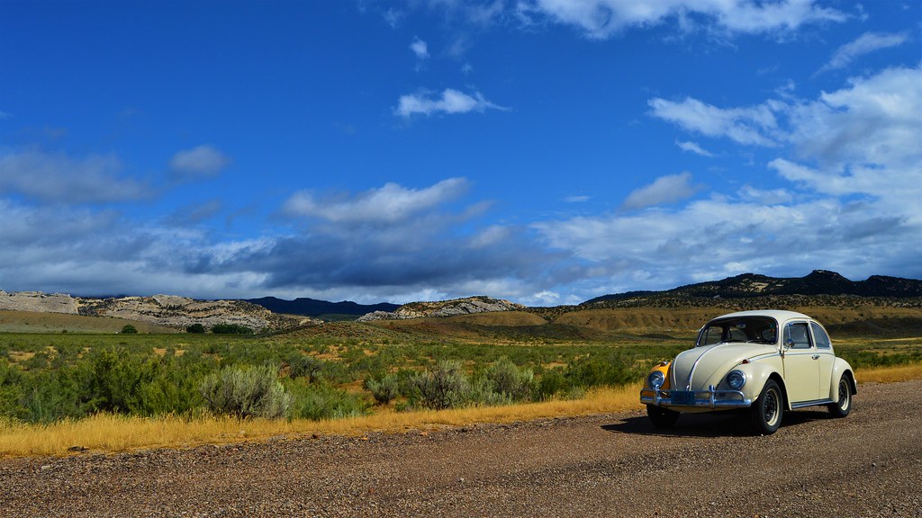
I'll start with a little back story as to the purpose of this trip. My good friend Nick from college called me up sometime in March saying he was getting married in September and wondered if I would be interested in coming to California to be in the wedding. I had not been there and seen him since I drove my 1966 Beetle out in July of 2013. I told him I would be happy to come for his wedding and decided to take the VW for another cross country adventure. Last time I drove the car to California I was living in Texas but now I reside west of Milwaukee, Wisconsin so a new route would have to be taken. About 2 weeks before departure I bought a suit to wear and "fixed" a leaking passenger axle seal. The day before, I changed the VW's oil, adjusted the valves, made sure I had all my spare parts and the necessary tools to replace them, packed up my stuff, and was ready to head west.
9-9-19
I woke up at around 5:00 AM, excited and a bit nervous, as would be expected when staring down a 4500 mile trip across the western United States in a 53 year old Volkswagen. My trip would take me across Southern Wisconsin, the heart of Iowa, the Sandhills of north central Nebraska, through Medicine Bow National Forest in Wyoming, over the Rocky Mountains of Colorado, and through vast mountainous deserts of Utah and Nevada, before traversing the Sierra Nevada and ending at Foresthill, California in the western Sierra foothills.
I fired up the Beetle's little 40hp engine and headed off into a gloomy drizzle with the temperature in the upper 50's. Rain would be the theme of much of the first day and consequently I didn't take any pictures. I was admiring the blooming goldenrod framing rolling cornfields along the road and must have missed a turn to stay on State Highway 59. I bumbled around for a little while, knowing the general direction I needed to head, and soon reconnected with my route when I found County M in Milton, WI.
I suppose at this point I should explain that I do not use a GPS, just typed directions and a well-worn 2014 Rand-McNally Road Atlas. People are always baffled when I tell them I travel the country using a map, but ever since my first solo road trip driving a 1980 Datsun 210 from Texas to Michigan, that's just the way I have always done it. In all my trips I have never been hopelessly lost, though there have been some instances where I have had to resort to a few lucky guesses to get where I was trying to go.
The last couple trips I have taken, about 1-2 hours in, a creeping anxiety to turn around and just go home has plagued my consiousness. This time is no different, but I turn on my little portable stereo and sing along to the music to divert my attention and after an hour or so I feel pretty good. The ripening fields of corn and soy, red barned dairy farms, low wooded hills, and small towns pass by as the VW hums along Wisconsin State Highway 11. Suddenly, I am heading down a long hill as the highway cuts through the sandstone and dolomite bluffs that border the Mississippi River valley in this area. In my opinion, the Mississippi River valley is one of the prettiest places in the upper midwest. I have spent a decent amount of time hiking in the bluffs above the river on both the Wisconsin and Iowa sides, and the views are spectacular.
The light mist transitions into a steady rain when Highway 11 joins the heavier traffic on US-61 as I make my way out of the bluffs and across the river. On the bridge over the Mississippi I can see fall approaching in the fading green of the tree-covered bluffs. Some bottomland maples on the islands have already begun to show a splash of yellow or orange here and there. The rain obscures the sweeping look at the river which is usually visible from the bridge and soon I enter Dubuque, Iowa. There are many huge old red brick buildings which line the highway along the river. I have never been to Dubuque, just through it, but those buildings are always a striking sight as they contrast the dingy grey concrete in front of them and green hills behind them.
The highway then starts the long climb up the bluffs on the Iowa side and I floor the accelerator as the VW trudges up while gradually slowing to the crest of the hill. This is the first of numerous steep ascents that will test the little car's meager 40hp 1200 engine in the days and states to come. I am now on US-151, a very interstate-like four lane divided highway that I follow along it's southwesterly path from Dubuque to Cedar Rapids across the heart of the Corn Belt. Since moving to the midwest and falling in love with the few bits of remaining tallgrass prairie, I am always on the lookout for native plants along the roadsides and 151 doesn't dissapoint. There are numerous sections of right-of-way covered in indian grass and big bluestem, with switchgrass making an appearance here and there as well. A few small oak savannas remain on hillier sections behind the highway fence, now maintained by cattle grazing instead of the fires of the past.
I merge onto US-30 on the outskirts of Cedar Rapids and bypass the city. In Iowa, US-30 is largely constructed along the path of the Lincoln Highway, a famous early transcontinental route across the country. The state has done a good job of signing where current highway deviates from the old road and by following the signs, you can travel on parts of the original route. On another trip I rambled along several fun old sections which were never paved. This time I followed a bypassed section which went through Marshaltown, IA before becoming a quiet county road paralling 30 for a few miles before rejoining it. A large 2-lane section of 30 though these parts is currently being widened to 4-lane divided. The project is largely in the dirt moving stage as I go through, and proves interesting to see the massive amount of work that goes into prepairing the land before the concrete is ever poured.
I leave US-30 in Denison, Iowa for State Highway 141 which leads me to County Road E34, a pretty little road through a very rolling landscape, which is the edge of the Loess Hills. The Loess hills are the result of strong western winds blowing drifts of fine outwash deposits left behind after the region's last glaciation. Eventually they stabilized with grass and trees to create a variety of thin ridges. The hills are a small preview of the massive and similarly formed Sandhill region of Nebraska yet to come. I enter Nebraska on a really neat old bridge at the end of Iowa Highway 175. Old bridges fascinate me, and this steel decked truss bridge was a real treat. The VW's tires make a resonant humming on the metal grating as I cross over the Missouri river to the town of Decatur, NE.
The rain stopped a while ago and now the sky is starting to clear into a hazy partly-cloudy afternoon. However the wind is also now picking up from the west. That doesn't bode well for an underpowered car trying to go west. I fight full-throttle into the strong headwind along a 65mph 2-lane road to little avail. The VW can barely hold 55mph in these conditions and everyone, including a school bus, passes me while my speed yo-yo's with the rolls in the terrain. Mercifully the landscape flattens, but the wind just gets stronger as Nebraska continues its valiant attempt to thwart my westward progress. In the end though the VW and I claim victory as we reach our stopping point for the day in Norfolk, Nebraska, roughly 500 miles from where we started. I am excited for tomorrow because I will be traveling through one of my favorite places in the country.
Last edited: