Abandoned/derelict sites

AbleGuy

Officious Intermeddler
IMG_2236.jpeg
While I love human history and am often completely held in awe of the incredible creations of man, my cathedrals have always been the wild ones I find in nature.

Yesterday we took a 3 1/2 hour hike exploring this island, first going through very crowded woods where we soon stumbled upon what was left of one of the original settler homes. The place had burned down long ago, and like many old burned cabins, the only remaining structure standing was the brick fireplace. Everything else had fallen to earth and been overgrown by bushes, shrubs, vines, and trees, becoming one with the soil… and there was no trace of the old orchard anymore either.
IMG_2237.jpeg

After exploring the old derelict Homestead, we broke through the forest onto the rocky shore of the south end of the island. We next were going to take advantage of the accessibility of the beach created by low tide and hike along this narrow tongue of land to try to find the remnants of an old brick factory we had been told about.

IMG_2239.jpeg

We wound up struggling along the slippery, rocky shore of the island, which was only temporarily accessible at low tide, scrambling over, and crawling under and through thick tangles of big Douglas fir trees that had fallen into the surf due to the undermining of their roots caused by the constant destruction of tidal erosion eating away at the shoreline.

IMG_2242.jpeg

IMG_2241.jpeg

We had to be very, very careful climbing over these obstacles to not tear up our clothes or our skin because of the danger posed by razor sharp barnacles that had attached themselves to and thoroughly coated the fallen trees’ bark during the higher tides.

Once we got around the point of land sticking out into the bay and we were able to look to the east, this is the incredible expansive view we were treated to:

IMG_2246.jpeg
 

Attachments

  • IMG_2239.jpeg
    IMG_2239.jpeg
    2 MB · Views: 3
Last edited:

AbleGuy

Officious Intermeddler
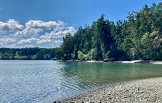
After we successfully navigated around the obstacle course forming the point of the peninsula, by hiking further along on the narrow crowded shore we found what was left of the site of the old failed and abandoned brick factory. There was nothing remaining of any of the original structures of the factory, or of the long timbered dock from which newly baked bricks were barged over to Seattle and Tacoma, except for various jumbled piles of old discarded brick and broken cobble lying on the floor of the forest and crowding the tide line.

Once, briefly, this was a thriving enterprise built hurriedly in response to fires that had burned down large portions of Seattle by quickly torching the wooden homes there. In response to those fires, a renewed interest in less burnable brick homes took root and brick kilns popped up in numerous locations around the Puget Sound.
IMG_2247.jpeg
IMG_2264.png

IMG_2244.jpeg


IMG_2249.jpeg

But this small factory wasn’t able to survive the competitive economics of the time. Other than the piles of discarded brick, the only thing that remained was a small historic sign posted in commemoration. There was an odd ghostly sense to walking through the woods here and trying to imagine that this abandoned empty site was once a place of such active commerce, full of the noise of men and horses and heavy machinery, belching, thick wood smoke up and into the otherwise clean salt air.

The shoreline from here on became dangerously muddy with warnings of the quicksand like nature of the tidal flat here. It was either hike through the mud, hike at the edge of the shore through wild tangles of prickly blackberries and stinging nettle and poisonous oak, or navigate back into the and through the thick woods to find the forest trail and head back home.

IMG_2252.jpeg

IMG_2250.jpeg


So we opted, of course, to cut up into the woods and find the original trail back to where we parked. We stopped numerous times along the meandering way back to our camper van to pick fresh blackberries and wild evergreen huckleberries,

IMG_2073.jpeg

which we took home and promptly cleaned.

IMG_2086.jpeg


IMG_2147.jpeg
Later last evening, my wife baked the most wonderful huckleberry and toasted pecan muffins, topped with a coffee cake crumble and similarly a huckleberry coffee cake.
IMG_2266.jpeg

I'm having one of the muffins right now with a cup of coffee as I sit out on the porch in the 59° damp morning air and look out into the green, green dripping woods behind our house (and soon the pan that the coffee cake sits in will be another temporarily abandoned, and derelict site, hidden back up in the drawer under the stove). 😁
 
Last edited:

Cabrito

I come in Peace
On our annual Thanksgiving hike we always pass this and I wonder what it was like when you were on guard duty. Location San Francisco Presidio former Army Base


This is the building / bunker that the guard shack was for


Technically the buildings are not abandoned and look like they're still in use for something.


NOPEC

Well-known member
Another mine, this one from the glory days when silver ruled in South Central BC's Kootenays...

Speaking of the glory days, Sandon, the small village near this mine is the home to one of the longest continually running hydro power plants in north america. The plant was installed 124 years ago by a fellow called Nikola Tesla and still provides all of the electricity to the village...... If you happen to own an EV by the same name, you can also charge it from this last remaining Tesla power plant in the world......
1746240625771.jpeg

Millions in Silver was removed from the area in the late 1800s and 1900s but sadly, not much from the old "Altoona"....
1746240669917.jpeg

never bad advice and a good reminder....... Lots of "sucker" shafts in the old diggings spread out through these mountains...
1746240737932.jpeg
 

AbleGuy

Officious Intermeddler
Another mine, this one from the glory days when silver ruled in South Central BC's Kootenays...

Speaking of the glory days, Sandon, the small village near this mine is the home to one of the longest continually running hydro power plants in north america. The plant was installed 124 years ago by a fellow called Nikola Tesla and still provides all of the electricity to the village...... If you happen to own an EV by the same name, you can also charge it from this last remaining Tesla power plant in the world......


Millions in Silver was removed from the area in the late 1800s and 1900s but sadly, not much from the old "Altoona"....


never bad advice and a good reminder....... Lots of "sucker" shafts in the old diggings spread out through these mountains...

Thanks for posting.

This is an absolutely Great area to explore…go to Nelson, stay at city campground, have an NBC and steak burger at Mike’s Pub (old Heritage Hotel) , drive up the lake north to Kaslo (check out the old steam wheeler), cut over the rugged mountains (very scenic drive thru wild country) towards New Denver past and through the Sandon mining district (great area for rough camping) and after a stop for pastries in N.D., head back south down Slocan Lake to Castlegar and on to Gladstone Provincial Park or loop back to Nelson…and make sure to keep a sharp eye out for bears (griz and blackies) along the way too. You might even see the extremely rare woodland or mountain caribou!

Or….go north at N.D. and loop all the way back to Nelson via Trout Lake (area is home to an amazing rainbow trout fishery…huge Gerard Trout) …or along that route stop at at Galena and take the free tiny open deck ferry boat across the lake and keep going up to Revelstoke and beyond.

Geezo…this is some of the most beautiful, most accessible country in SE B.C. and now you guys know. No crowds. Put it on your list!
 
Last edited:

NOPEC

Well-known member
Thanks for posting.

This is an absolutely Great area to explore…go to Nelson, stay at city campground, have an NBC and steak burger at Mike’s Pub (old Heritage Hotel) , drive up the lake north to Kaslo (check out the old steam wheeler), cut over the rugged mountains (very scenic drive thru wild country) towards New Denver past and through the Sandon mining district (great area for rough camping) and after a stop for pastries in N.D., head back south down Slocan Lake to Castlegar and on to Gladstone Provincial Park or loop back to Nelson…and make sure to keep a sharp eye out for bears (griz and blackies) along the way too. You might even see the extremely rare woodland or mountain caribou!

Or….go north at N.D. and loop all the way back to Nelson via Trout Lake (area is home to an amazing rainbow trout fishing…huge Gerard Trout) …or along that route stop at at Galena and take the free tiny open deck ferry boat across the lake and keep going up to Revelstoke and beyond.

Geezo…this is some of the most beautiful, most accessible country in SE B.C.
Ableguy

Wow, high (and incredibly detailed..) praise for this little corner of the world! I see our local CofC is hiring a summer touristy staff person. You would be a shoo-in for the job! I could make a couple of calls.......

PS: As good as NBC is, don't forget to check out the AH in Kaslo. The "What the Cluck" IPA is superb.....

logo_angry_hen.jpg
 

Forum statistics

Threads
189,212
Messages
2,914,438
Members
231,957
Latest member
lkretvix
Top