Expeditionary Compass - Mounting on Windscreen - Maxing Out

maxingout

Adventurer
Thanks to everyone for the great info. I came across this sun compass/clock application a while back and am intrigued to try it someday. It creates a sun compass for a particular date and latitude. You print it out and set it up with your own pointer. Once set up correctly it is apparently very accurate to steer by in a vehicle. No problems with magnetic deviation. On the site there is a guy from Australia who actually used this to navigate a section of the outback.

David

http://chrismolloy.com/sunclock

I had an old Davis Pelorus with a rotating azimuth card on it, and it made a great sun compass. The problem was that it was plastic, and I eventually broke it when I was sailing offshore around the world. There was a center pin that cast a shadow on the azimuth card, and you rotated the azimuth card to the true bearing of the sun for that time of day at your assumed latitude and longitude. Once the azimuth card was oriented to the sun, you could use the two plastic sighting vanes to get true direction rather than magnetic direction. It was magic once the azimuth card was properly oriented. Unfortunately, you have to keep moving the azimuth card as the sun changes in position in the sky. It's a little tedious but it does work very well. Taking bearings on the sun with a pelorus is one of the classic ways that compass adjusters used to make their living.

A sun compass isn't rocket science, but it is a bit of a hassle because the sun is moving in the sky, and you are moving on the earth's surface as you navigate. So you have to take that into consideration as you take your bearings and run your courses. It isn't GPS, but a great deal of big time navigation has been done only with a sun compass and celestial sights. Nearly a hundred years ago Bagnold and the Long Range Desert Group in the Libyan and Egyptian deserts were masters of the sun compass, and it worked well for them
 
Last edited:

David Harris

Expedition Leader
I had an old Davis Pelorus with a rotating azimuth card on it, it made a great sun compass. The problem was that it was plastic, and I eventually broke it when I was sailing offshore around the world. There was a center pin that cast a shadow on the azimuth card, and you rotated the azimuth card to the true bearing of the sun for that time of day at your assumed latitude and longitude. Once the azimuth card was oriented to the sun, you could use the two plastic sighting vanes to get true direction rather than magnetic direction. It was magic once the azimuth card was properly oriented. Unfortunately, you have to keep moving the azimuth card as the sun changes in position in the sky. It's a little tedious but it does work very well. Taking bearings on the sun with a pelorus is one of the classic ways that compass adjusters used to make their living.

A sun compass isn't rocket science, but it is a bit of a hassle because the sun is moving in the sky, and you are moving on the earth's surface as you navigate. So you have to take that into consideration as you take your bearings and run your courses. It isn't GPS, but a great deal of big time navigation has been done only with a sun compass and celestial sights. Nearly a hundred years ago Bagnold and the Long Range Desert Group in the Libyan and Egyptian deserts were masters of the sun compass, and it worked well for them

So am I right in thinking that you could use a sun compass to check the deviation in your magnetic compass mounted in a vehicle and adjust accordingly?

David
 

maxingout

Adventurer
So am I right in thinking that you could use a sun compass to check the deviation in your magnetic compass mounted in a vehicle and adjust accordingly?

David

That is the way some compass adjusters do it on yachts. A sun compass will give you true headings, and you will be able to make a deviation table for your compass.
 

chris snell

Adventurer
I'm all for using a compass. Land navigation with simple tools is a lost art outside of the military. Map reading, terrain association, resection, etc. are great skills to develop and they take practice to maintain.

I'm not a fan of that ridiculous giant compass, though. I don't trust anything inside my truck, calibrated or not. Get a handheld compass, get outside of the truck, look around and terrain-associate.

This is what I use:

94uZSZTYICmbbwCeTnJwvuN8LMxy71sXY04Buv-jv5R9ErDzZ8knzez_dRSLGMpWylER0MiBSlyGpX4C1ULIRv0N-xkCyaVVb3SVctOgUi-PPEjUs09COQHt_9kuaEPHD4YVwmOssC3NfZ76dFfsiTnHoE2R7uRLejlg5eQv2i1j3yU7R9EivE76bViZjt9iQEzhdDLGzlkL5m_SHUjv4nP8-UguI6Rg2EGAqCjImN0riRHKQUzfUiBHS6NVqoZEYqPtqqQN64u8_aD-O6SpLGF-WWqrBCIwXl0imLOUzrQ5XDOK3S-wBZqWnTQR57uH


http://www.google.com/products/cata...a=X&ei=QzR1T6OEHYTkggelj_3nDg&ved=0CF0Q8gIwAQ

Simple, packs down to almost nothing, perfect for shooting a quick azimuth outside of the truck. That, a mechanical pencil and a well-cut protractor with the right scale for your map, is all you need.

Some good reading: FM 3-25.26 http://www.uvm.edu/~goldbar/FM3_25.26.pdf
 

Scott Brady

Founder
I don't trust anything inside my truck, calibrated or not.

There are some good options that provide for deviation adjustment. With deviation adjustment or compensator magnets there are no downsides to a mounted unit from my perspective. I do agree that the compass above seems unnecessarily large. I find value in having a compass mounted in the vehicle, especially when running in the deserts. A few years ago I stopped having a GPS mounted and running on the dash, so a compass is a quick validator of the route without having to stop.

I also carry the lensatic compass you linked to. I have used it for about 20 years since the USAF. A good unit, reasonably priced and classic.
 

Scott Brady

Founder
Many people regard non-electronic compasses as old school and downplay their role in expeditionary travel.

Thanks for posting the detailed review Dave. You need to take that 110 into the Altar now - I can give you a starting waypoint and a few compass bearings ;)

424394_10150755230273275_640113274_12420520_238683592_n.jpg
 

maxingout

Adventurer
I actually have more compasses than the Pope has Catholics.

I have compasses in binoculars, hockey puck compasses, and a variety of electronic compasses.

Many people don't know that hand held compasses are constructed differently for work in the northern and southern hemispheres. A hockey puck compass designed for the northern hemisphere may give inaccurate bearings when used in the southern hemisphere. The compass card tilts differently in the northern and southern hemispheres, and there may be enough friction between the compass card and the body of the compass that the card will not settle properly on a heading, and you will recieve a false reading. Manufacturers modify the construction of the small handheld compasses according to the hemisphere in which they will be used. I have read articles about yachts that had significant navigational problems because their handheld did not work properly in the opposite hemisphere.

When I purchased my first Defender in Arabia, I mounted a first generation electronic compass with a large electronic read out on my dash. We had to drive in figures of eight for it to self-calibrate and give accurate readings.

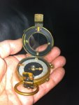
One of my favorite hand held compasses was given to me by my father-in-law. He was in UDT-4 (Underwater Demolition Team 4) which was the precursor of today's Seal Teams. If you go to the Seal Museum in Fort Pierce, Florida, you can see his picture on the wall as a member of UDT-4.

UDT SEAL TEAM 4 COMPASS.jpg

This is the compass he used as a member of UDT-4 when he was in the Pacific blowing up stuff on the beaches in World War II before troops landed. This compass has thousands of war time miles on it and has seen combat in the Pacific. He gave me the compass because he knew how much I like navigation tools, and this one is the real deal.

I have a least 4 hand held compasses, one compass in a monocular, and one compass mounted in a binocular.

The UDT-4 compass is the most special.

My favorite compass for navigating in my Defender remains the Plastimo Iris 100, and I have had them in at least three of my Defenders.

The best compass for expeditionary travel is the one that makes you the most situationally aware. The Iris 100 serves that pupose well for me, and since it can easily be removed from its mount to check bearings away from sources of magnetic deviation, it also keeps me honest rather than just optimistic about where I am and where I am going.

It really doesn't matter what compass you use, as long as you understand its limitations. In sailboat navigation, we avoided relying on a single source of navigational information. We always tried to have at least two independent sources of information, and when they confirmed each other, we knew that we were ok. And when they disagreed, we slowed down or stopped until we figured out what was happening.

For me a compass does two things. The first is simply to tell me the direction that I am heading and bearings to signficant landmarks. The second is probably even more important. It serves as a constant reminder to pay attention to what I am doing as I navigate cross country. Before I head out, I need to understand the navigational challenges posed by the trip, and the compass reminds me that I am constantly working to solve that navigational problem.
 
Last edited:

chris snell

Adventurer
The best compass for expeditionary travel is the one that makes you the most situationally aware.

That is truth. I shake my head every time I see an iPad or laptop mount in a truck. People install these things because they believe that they will improve direction-finding and orientation but they tend to have the opposite effect. There's nothing wrong with using an iPad for route planning I but I believe that many rely too heavily on them while driving and lose sense of what's around them. Chartplotters are neat but pretty useless if you need to abandon your truck and walk out on foot. If your emergency plan involves a GPS, you're going to be in trouble when the batteries run out. Having the proper tools and skills for battery-less land nav is, in my opinion, imperative for any backcountry trip.


My nightmare scenario is a solo trip to the desert and a sudden vehicle fire leaving me little time to grab gear. For this reason, I like keep my maps/compass/protractor and my handheld 2m radio in a NOMEX Combat Vehicle Crewman (CVC) bag behind my center console, ready to grab quickly in an emergency. The bag is flame-retardant, durable, and the perfect size for holding my National Geographic maps, the radio, my knife, and some spare batteries.
 

maxingout

Adventurer
That is truth. I shake my head every time I see an iPad or laptop mount in a truck. People install these things because they believe that they will improve direction-finding and orientation but they tend to have the opposite effect. There's nothing wrong with using an iPad for route planning I but I believe that many rely too heavily on them while driving and lose sense of what's around them. Chartplotters are neat but pretty useless if you need to abandon your truck and walk out on foot. If your emergency plan involves a GPS, you're going to be in trouble when the batteries run out. Having the proper tools and skills for battery-less land nav is, in my opinion, imperative for any backcountry trip.


My nightmare scenario is a solo trip to the desert and a sudden vehicle fire leaving me little time to grab gear. For this reason, I like keep my maps/compass/protractor and my handheld 2m radio in a NOMEX Combat Vehicle Crewman (CVC) bag behind my center console, ready to grab quickly in an emergency. The bag is flame-retardant, durable, and the perfect size for holding my National Geographic maps, the radio, my knife, and some spare batteries.

I like your idea of having a "Go Bag" in your truck with essential survival gear in that bag. We did the same thing on our sailboat.

I knew someone in Arabia who had their truck washed away and buried in a flash flood never to be seen again. It took them a couple of days to walk out . A "Go Bag" could have helped them out.

Thanks for the idea.
 

BigSwede

The Credible Hulk
Heh, you guys will shudder, but I have a little $3.99 compass, just a little ball on a suction cup mounted on the windshield up under the mirror. Works fine for general direction, never seen any significant error.

I do have an orienteering compass for "serious" direction finding.
 

maxingout

Adventurer
Heh, you guys will shudder, but I have a little $3.99 compass, just a little ball on a suction cup mounted on the windshield up under the mirror. Works fine for general direction, never seen any significant error.

I do have an orienteering compass for "serious" direction finding.

With two compasses, you are defintely heading in the right direction.
 

Antichrist

Expedition Leader
That is truth. I shake my head every time I see an iPad or laptop mount in a truck. People install these things because they believe that they will improve direction-finding and orientation but they tend to have the opposite effect
It really depends on how you use them. I've used laptop mapping software for around 10 years. But I also work "intimately" with computers and know just how much faith you should put in one. Very little.
If I'm doing a trip with a narrow deadline the laptop helps with quickly finding the shortest alternate routes in unfamiliar areas.
If I'm traveling recreationally I prefer paper maps, or not even using a map at all if it's recreational exploring.
 

AzRover

Observer
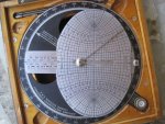
sun compass.jpg
A sun compass that was for sale on Ebay a while ago. I was out bid...
You can also use a watch as back up. Point the houre hand at the sun, and south will be 1/2 way between the hour hand and 12:00.
My Disco has an electronic compass in the mirror.
I also keep a old hand held gps in the glove box as back up to my large boat gps.
Steve
 
Last edited:

Forum statistics

Threads
186,490
Messages
2,886,596
Members
226,515
Latest member
clearwater
Top