Roverhound
Adventurer
Thanks for posting this up...it's a good set of maps. Gives a much better idea of what goes where than my GPS does and should cut down on back-tracking.
Unfortunately, with regards to the discussion at hand, it does not show enough detail to have allowed Clark to know where the "legal crossing" was or was not.
I will be the first to agree they don't show enough detail, but it does show a straight road.
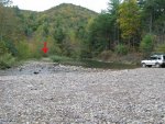
I guess my main concern here is the interpretation that a crossing through 3" of water is preferable over a crossing that is 10' feet away with about 6" of water.
The crossing chosen was nothing but a photo op.
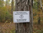
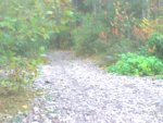
Mr. Clark, if you had really scouted the area you would have quickly found the obvious trail that leads off of city of Harrisonburg property and on to Dry Run Rd.
The loop through the river that was taken is plain and simple, not a trail.
I believe the main reason there are no signs is the fact that it is a river bed.
Maybe this will explain it better. This is the same "crossing".
Any way, I think I'm done here. Seems like with the exception of Mr. Ed and Mr. Clark you guys aren't really getting it. It's really a shame, this trail provides some decent fishing access as well as access to Dry Run Rd.
Attachments

Last edited: