The Arizona Strip, May 9-15 2009

richjeeps

Eagle
Thank you very much. I'll show my wife your comment when I get home tonight.

Wow! Great TR. I dont know how I missed it. I'm going to AZ Strip mid July. I know it's not the best time weather-wise but other factors are involved. Can you share any GPS data? Thanks for posting. Rich
 

xpdishn

Adventurer
Sent you a PM on some GPS coords. See if they help. Have a great time out there.

Remember the Bar 10 Ranch now sells fuel and always has had water.
 

richjeeps

Eagle
Sent you a PM on some GPS coords. See if they help. Have a great time out there.

Remember the Bar 10 Ranch now sells fuel and always has had water.

THANK YOU!

Do you know if the Bar 10 serves dinner to drop-ins? I think it would be a great place to stop and eat.
 

xpdishn

Adventurer
The Bar 10 does'nt or did not serve meals to the outside public, only to their own guests. They do have showers there though that makes up for it. I would rather have a shower after a couple/three days on the trail than a meal served to me. They do have a gift shop with cold drinks and snacks, though again no ice cream.
 

noJeepshere

Adventurer
Awesome trip! My dad, grandpa (85 years) and uncle went on a trip through the San Rafael Swell in NE Utah two years ago, very much like this trip. Camped out under the stars, mostly dirt road driving, a few technical spots, and a BLAST!! Reading about your trip got me excited to do a similar trip soon :cool:

And your thread on the FJ forum showed me how to wire up and plumb the extra tank I'm going to install on my truck.
 

richjeeps

Eagle
The Bar 10 does'nt or did not serve meals to the outside public, only to their own guests. They do have showers there though that makes up for it. I would rather have a shower after a couple/three days on the trail than a meal served to me. They do have a gift shop with cold drinks and snacks, though again no ice cream.

Thanks for the info. I plan to stop there.
 

ExpedH3T

Explorer
Gary, planning a shorter trip out there......wifes first....took her backpacking in the snow for our first anniversary....she's a trooper....I think she would enjoy this. I was wondering if you still had those GPS coordinates available?
BTW your wife sounds like an awesome lady!

Matt
 

WildHare

New member
I would also like a copy of those GPS files myself.

Thanks

-Dan


Sent from my DROID RAZR using Tapatalk 2
 

xpdishn

Adventurer
Gary, planning a shorter trip out there......wifes first....took her backpacking in the snow for our first anniversary....she's a trooper....I think she would enjoy this. I was wondering if you still had those GPS coordinates available?
BTW your wife sounds like an awesome lady!

Matt

I would also like a copy of those GPS files myself.

Thanks

-Dan


Sent from my DROID RAZR using Tapatalk 2


I have received quite a few PM's about this through the years and thought it was time to get this information into the trip report.

Take a look at the legend at the end for explanations of the coords.


Fw: Arizona Strip intersections

quote_icon.png
Originally Posted by xpdishn
here's what I have been sending many people. This route will keep you as far south as possible and still be able to travel east (or west, depending) without running into a dead end:

I bet using Google Earth and the Benchmark map would be the best way for marking a route. Haven't tried it though.

AZintersectioncoords3.jpg


AZintersectioncoords4.jpg


AZintersectioncoords3a.jpg


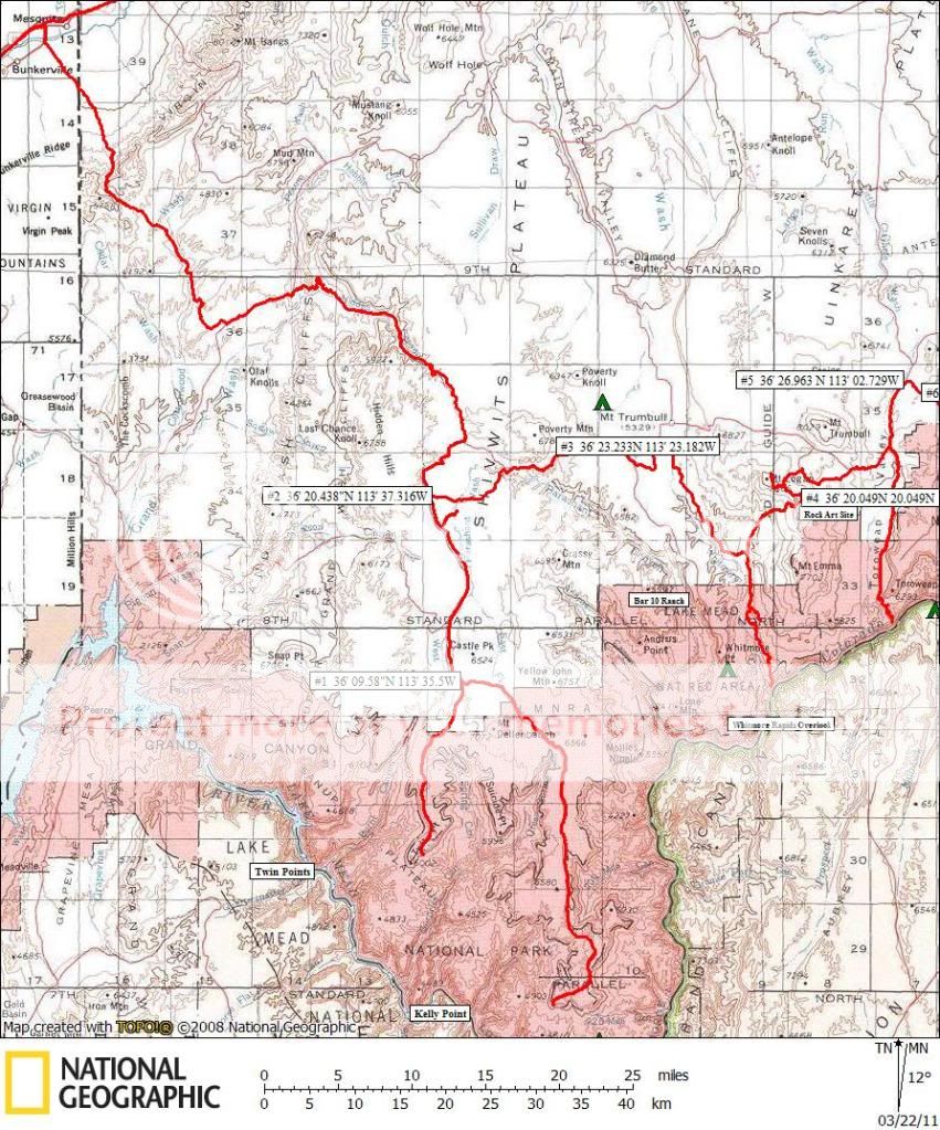
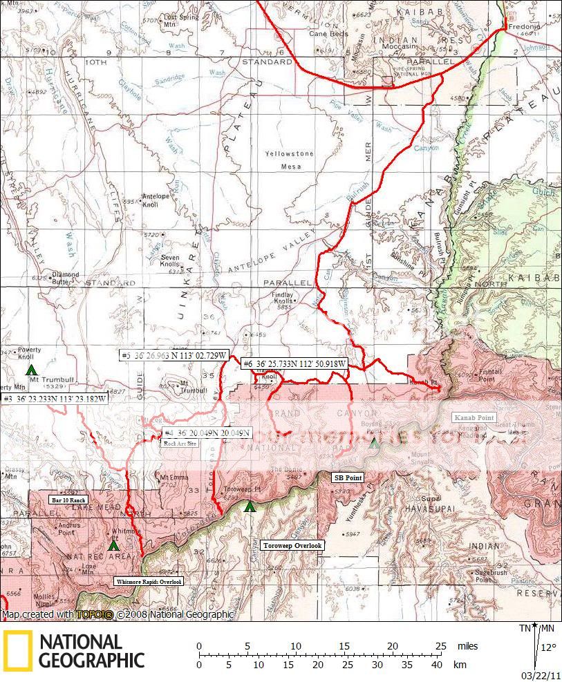
Attached is a map with the coords at the important junctions. A few notes about each one:

#1: This is a well marked junction just north of Oak Grove. This trail goes to the Waring cabin and Kelly Point.

#2: This is the very first road that goes thru to the east. All other roads do NOT go thru, no matter what any map shows.

#3: Start heading south.

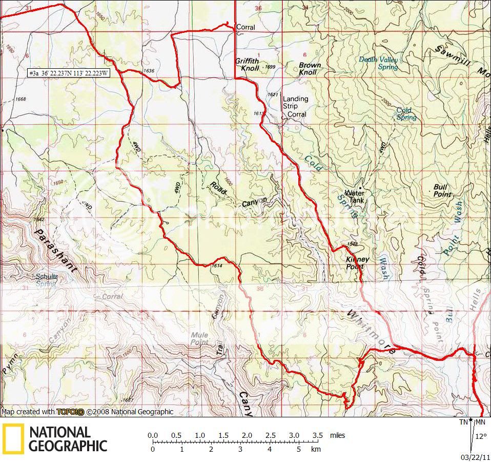
#3a: 2nd attachment. Take this route, very pretty and easier to find route to the Bar 10.

#4: Very important to go north at this junction. To go east will end at a locked gate many miles in.

#5: This junction is after you visit Toroweep overlook and start north again. Head east again here.

#6: This will get you headed south to SB Point.

This should help.


Eped, your comment about Paula is exactly right. She will really appreciate your words.


Last edited:

Sngltrak1

I wonder were that goes..
My 13 year old son and I are going to do twin point and Kelly point next weekend. We are going to leave Las Vegas on Friday the 21st around noon and hope to make it to oak grove with enough light to set up camp. Will do the lookouts on Sat and camp around Kelly point Sat, return to Vegas on Sunday!!! Basically just doing the first two days of your trip. I'm thinking I will need at least an extra 5 gallons of gas for my Tacoma, but probably will have 10 gal just to be safe. Can't wait to get out there!! Thanks for posting this thread...
 

xpdishn

Adventurer
My 13 year old son and I are going to do twin point and Kelly point next weekend. We are going to leave Las Vegas on Friday the 21st around noon and hope to make it to oak grove with enough light to set up camp. Will do the lookouts on Sat and camp around Kelly point Sat, return to Vegas on Sunday!!! Basically just doing the first two days of your trip. I'm thinking I will need at least an extra 5 gallons of gas for my Tacoma, but probably will have 10 gal just to be safe. Can't wait to get out there!! Thanks for posting this thread...

Hope you have good weather and enjoy your trip. As for the fuel, fill up in Mesquite, and with your extra you should be just fine.

We are actually heading out for most of a week first thing tomorrow morning and start with Twin Point and going east as far as we can. Showing the sights to a friend from Canada.
 

Sngltrak1

I wonder were that goes..
Hope you have good weather and enjoy your trip. As for the fuel, fill up in Mesquite, and with your extra you should be just fine.

We are actually heading out for most of a week first thing tomorrow morning and start with Twin Point and going east as far as we can. Showing the sights to a friend from Canada.

Sounds like another great week ahead for you. We might be pushing our trip back a week....tying to figure out what will work best. Will be looking forward to any post you may have!!
 

explouis

New member
Gary,

Thank you for posting map with coordinates. We're not heading out til Oct 4th so would like to hear what you discover when you come back. Have fun.

Louis
 

magoh76

Adventurer
Thank you so much for this report and your maps! We are taking the kids (there will be 5 of us total) to the North Rim and 4 Corners area in early June and this has helped tremendously.
 

Spitfire

New member
I did it 2 yrs ago and it was incredible. 5 days, 4 overlooks. Worked from Kanab back West. Saw 1 hiker and 1 truck (another expo member) the whole trip. Waking up in the bed of the truck watching sunrise on the canyon was incredible. I just purchased the updated parashant map from the NPS and did on the fly route planning with gps fixes. We went over Mt Trumbull and down through hells gate, which was the only real offroading, on the way to Whitmore.
 
Last edited:

Forum statistics

Threads
189,887
Messages
2,921,889
Members
233,084
Latest member
Off Road Vagabond
Top