who is using a real gps vs a tablet

1Louder

Explorer
iPad and Gaia GPS. No complaints. Feature packed and well supported. If you don't need all the map layers offered that's ok. At least they are an option. Great support team. I suggest reading some of the many other threads on this topic. iOS is very reliable in general compared to my experience with Android. I am not talking about the apps just the ecosystem. Shane4x4 and I like to go back and forth on this topic. Competition is good. Hema should step up and do more updates.
 

pluton

Adventurer
Garmin Montana - I had 3 phones and 2 tablets since I bought my Montana. I buy my stuff at GPS city.


http://www.gpscity.com/garmin-montana-610-motorcycle-street-mapping-bundle
This^^^
My truck is small(old 4Runner), so the small screen of the Montana sits pretty close to me and is therefore [barely]acceptably readable. A Montana with a 6" screen would be killer.
And...I pop it out and can take it hiking and it's a real GPS...without the extreme battery drain of a smart phone. And...you can't conveniently take a tablet hiking...at least I can't.
Tablet, or mini-tablet would be great for the bigger screen, but I have found the functionality of the iOS apps like Gaia to be like amateur hour compared to a real GPS.
>>[EDIT-3.5 years later]: Since 2017, Gaia upped their game and eliminated what I called the 'amateur hour' functioning of the old Gaia pre-subscription app. Gaia, as I experience it now on an iPhone Xr has two great advantages over a modern Garmin unit:
1. You can use actual USGS 24K topo maps, plus the lovely ESRI enhanced versions of same.
2. The speed of the UI of an iPhone is noticeably superior to the speed of even the newest Garmin units; Montana 700/700i are the ones I have recently used. Entering waypoint info on the Garmin 700 series is not the interminable death march that it was on my old Garmin 600 series, but, at best, you have to go at about 1/2 the speed that you can on an iPhone.
However, all is not perfect in Gaia World: This last weekend (March, 2021), I was in the Mojave Preserve. Gaia kept trying to tell me I was in a certain spot, even when I had moved about 25 miles away from that location. The glitch continued for over 24 hours, and then evaporated...never to return. I don't know whether it was a GPS problem, a Gaia app problem, or an iPhone problem. The Garmin unit I had with me (Montana 700i) had me at the correct location the whole time.
 
Last edited:

dms1

Explorer
I use a Garmin Montana and a Samsung Galaxy Tab 2 with Gaia, im still learning Gaia. but once I master it I will probably only keep the Montana as a backup.
 

gfiero

Adventurer
I use a 7" Samsung with Delorme's Earthmate on it and have had great results, of course navigating without uploading your route is a pain. I have a Garmin Nuvi 500 that has the western topo's on it as a backup, and I have played with Backcountry navigator, and was not really satisfied the combination, app or tablet, not sure. I have used a laptop with Delorme and like it, still use it, I also like Basecamp it is as said easy to use most of the time though I find it tries to read my mind at times. (Even my wife can't do that). I do not use a IPhone due coverage issues when there is no cell service, and since I prefer to be where there is no cell service I don't use the phone. I have used GPS's since beta testing the Garmin 46(?) in 1993, and am still lot happier with the data being up to date, something not always true. So let me make a plug in for paper maps, use them, have them, refer to them, and Keep them
 
I think I figured it out I am still using USA topo maps which is very similar to backcountry only with what I think is a much better selection of maps. I put a 128 gb chip in the tablet and then starting copying the older maps at level 15 the older map according to he description have more "trails" so you select the place you want to down load to in this case an sd card. then go to cache map select the area you want. hit the cache button upper right corner of the screen and then downloads if you for max detail on these maps it might take an hour or so. on some of the other maps it took a half a day. then when it fully downloaded it wills you download click on it and in about 15 seconds the area you copied via the cache map prompt is on your tablet. Bet of all the price for the non pro level it is free. for the prolevel big spender that I am it was $11.99 as in like 12 bucks. I spent a few day downloading every area I wanted and this means all of the west coast off road areas in wash Ore calif and Arizona, at 15 level zoom then the entire state at 13 level and then all of the forest service maps for all of ca also at 15 I still have 98 gb left on the chip. now to see if they all work the maps are there and I know the tablet tracks me well Just have to try it out. I have used a gPS since the first soni was available in the 90s I have had 2 garmins, 2 lowrances, a Panasonic and a few others. This system seems to be great. The lowrance are far to superior to any of the other gps. One garmin that I had Loaded on topo maps and you could use it as on overlay overt he street maps but they didn't line up! weird frustrating etc. on using the older maps when we were in Arizona for the expo my son was using this and we found trails that were so overgrown as to be not passable you could barely make out the tire ruts and many of these had been completely reclaimed by the forest. Check it out. see what you think. Th only caveat I see and I am not sure if it is an issue is that using the 10 inch screen you can cover more area than you could on a smaller screen so it might take longer. but for me one of the reasons I went with a 10 inch tablet is for the screen quality and size.
 
We've considered several options and should have a choice selected within a few weeks, However, being cheap, any new tablet/phablet is way too expensive for us, plus adding a net services (monthly fee) isn't idea of fun. The issue we're having is actually location a tablet/phablet which is unlocked that allows for the use of a straight talk type plan, as tracfone doesn't allow for tablets.

Currently we're using our LG smart phones as location devices. but once the tablet has been purchased all of this location data would be removed. Google Maps is a big "IF" right now as they have updated their system as to force users to have the Google play services (not the actually google play store) open all the time.. the phones have drained twice since this update and I've since blocked the google play serves with Opera max. We're between a rock and a hard place and we're just not willing to spend more than $200.00 for a tablet and a service.

The only other options is to visit the local pawn shop and hope we can locate a tablet which is unlocked that allows us to connect to straight talk of an alternative pay as you go data plan. Back to google maps for a second.. because of this update (which displays adds, weather etc) at the bottom of the screen which wasn't like this before.. we're left with sites like Mapquest which we've yet to test on a long trip.
 

FJOE

Regular Dude
Garmin Montana 650T. Great all around GPS. Also Garmin GPSMAP 60CSX for handheld.
 
Hi trail badger here is what I have finally figured out and successfully passed the first dry run I bought a Lenovo 10 inch a2 tablet about 170 but you could get a much less expensive one. Just be sure it has gps then I purchased us topo maps pro $12 and 128 gig micro chip about $58 but you get get by with a smaller chip. Once I figured it out I now have topo maps for the entire state minus area like Fresno etc. so if you wanted to be really frugal find a tablet with gps you don't need monthly service for gps get a chip be sure to get atablet with external storage and us topo maps the free version. Or splurge and get pro
 
@Jeep or Tacoma the topographical maps are way over our head and to complicated, tethering isn't an option for us and against the terms of our service, unless we actually purchase a mobile hotspot. We'll do nearly the same as you and selected a no name brand of tablet of locate one at the pawn shop and just assign it to the straight talks plan and pay as we go for less than $15.00 for 30 days of service.

Again, if one is constantly on the road, than a Garmin or Rand Mcnally type device would be a better option for us. But the imaging isn't very desirable. Google map and mapquest have the view we're interested in as this would be something we'll explore once the device has been selected.

More importantly, how is the device is stored and mounted in an area thats accessible to the driver and passenger. Because not only will this device sever as a navigator tool, but for our back up camera set up. I've submitted a rough drawing of a new type of tablet/phablet retaining system for the jeep. We'll see when they can begin work on this.
 

Tswhit15

Member
I was having trouble deciding on a GPS/Navigation setup and eventually went with partially what I had available. I currently run (in my jeep) a 12" 2-1 laptop (folds into touch screen tablet) obviously I have a converter for power, and I use a USB globalsat bu 353-s4 gps unit (25$). On my laptop (windows 10) downloaded MapsPro for 4.99, then USA and Canada pack for 10$ each, and it's plug and play with the usb GPS. Never had a single issue with it once I got passed the brief learning curve. Take it on tiny north maine woods logging roads, brought it along the translabrador highway in Canada, and all the BLM roads in Colorado/New Mexico so far without problems and seemed pretty accurate. If I'm spending significant time in remote areas or hiking I usually print out the USGS topos, which are free. But you can overlay mapspro with most other types of maps also.
 
Nice tele about maps pro. When you downloaded all of USA what do you get?are they topo maps ? By who and to what scale? how much space does it take up? and are there other options available like say air photos or us forest service maps? Thanks
 

Magellan TRX

Magellan GPS Marketing
"The Magellan TRX is also way overpriced for what amounts to vector maps with a dump of USGS data. The idea of syncing is OK, but tagging trails for others is over-implemented IMHO."

Actually, our map is OSM, and trails are from each area's managing authority, and not just a "dump", but a living and breathing system that's constantly updated as we work with the Forest Service, BLM, and States, and always free. The map and trail data are always available via the free Magellan TRX app and at www.TRXtrailhead.com
 

shane4x4

Supporting Sponsor
"The Magellan TRX is also way overpriced for what amounts to vector maps with a dump of USGS data. The idea of syncing is OK, but tagging trails for others is over-implemented IMHO."

Actually, our map is OSM, and trails are from each area's managing authority, and not just a "dump", but a living and breathing system that's constantly updated as we work with the Forest Service, BLM, and States, and always free. The map and trail data are always available via the free Magellan TRX app and at www.TRXtrailhead.com

I understand the idea of a leaving breathing system, and I think it's admirable. Case in point though...
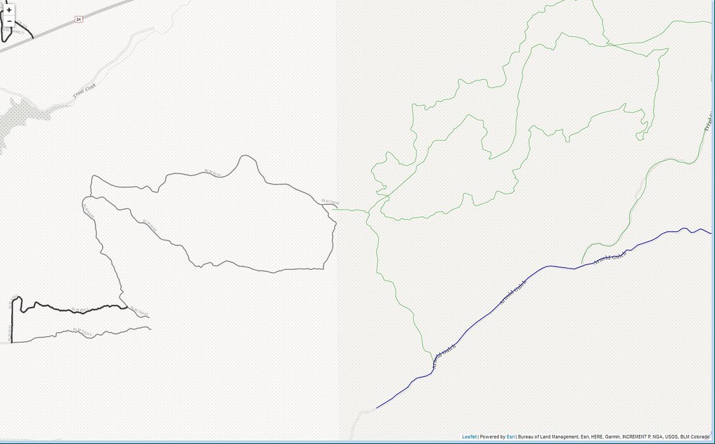
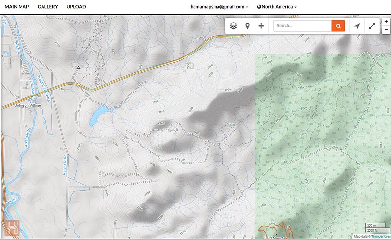
Chinaman Gulch, Colorado.

This is the test I run on ever map layer I see, and so far no one has all the data with appropriate metadata from the managing authorities.
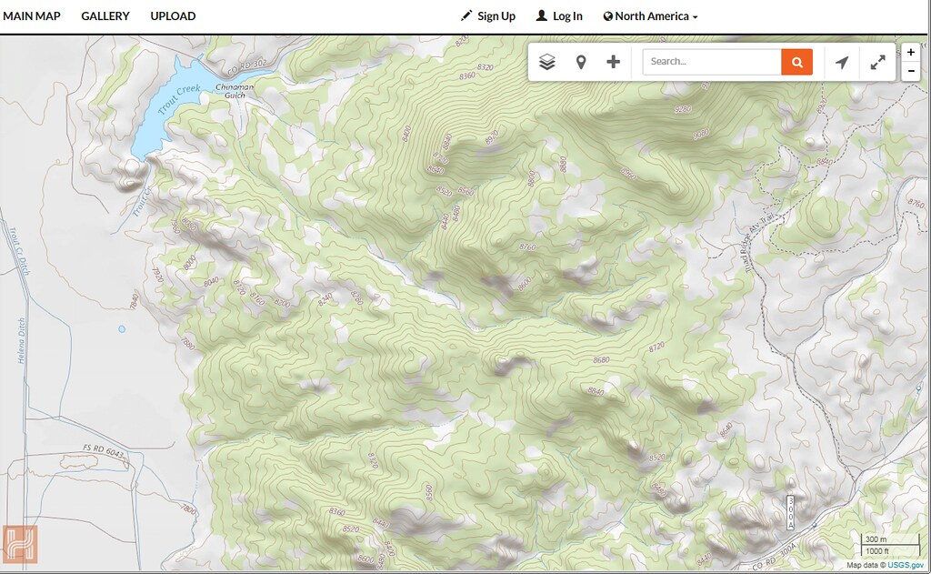
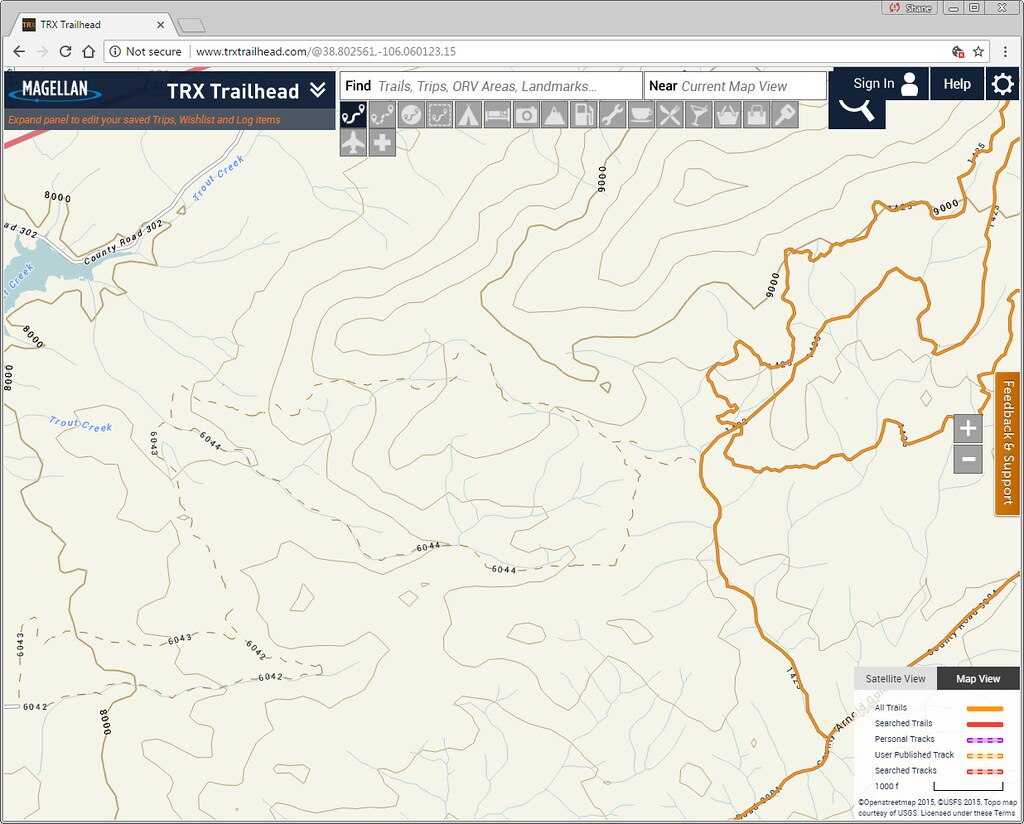
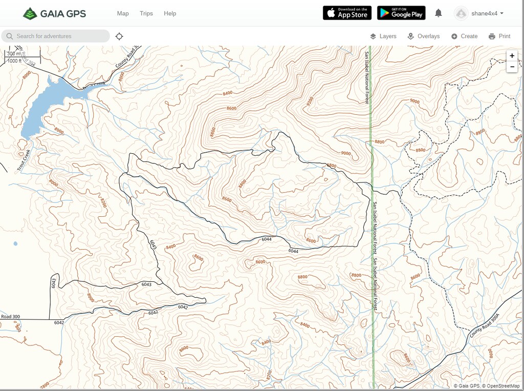
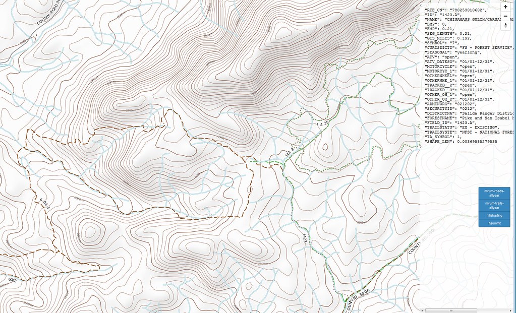
Chinaman Gulch (38.802561,-106.060123) is a trail near Buena Vista, CO that is on BLM land and managed by the BLM, but is right next to USFS land. OSM shows the information a decent level of information:


So does the Magellan data, for the USFS portions. Note that the Magellan data (and most other sources) does not include BLM metadata
35592070150_152531b7b1_b.jpg


And USGS Topo (Doesn't even show it)


And Gaia Topo
35939623836_463b111c65_b.jpg


Finally some test layers I've been developing
35810387532_23b8fe9de7_b.jpg


35141264254_d6cd644dfc_b.jpg


The issue is that there are at least 5 different federal agencies that manage public land, plus state & local land & trail areas, it's basically impossible to have a single layer that contains all the data someone may need. Personally, I prefer to have multiple useful layers to choose from, as well as real reports from other that have explored the area.
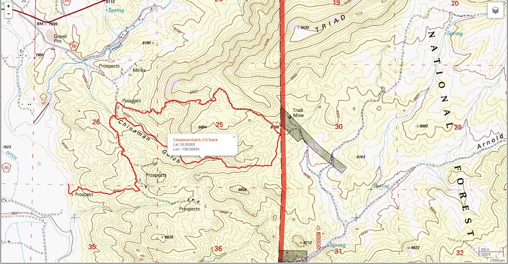


Using 1 layer just doesn't work in my very personal opinion.

So...use whichever device, app, service you like...just know that there's no such thing as 'one version of the truth' =)
 

Magellan TRX

Magellan GPS Marketing
With the TRX system, you have the choice of using the government supplied data, the basemap, user generated tracks (so you can see what others experienced), or imported GPX files. You're right, the BLM hasn't supplied us with trail data yet for Chinaman Gulch. But it's in the basemap, so I was able to create a route on it in a few minutes on the TRX Trailhead site. Here's a link to it: http://bit.ly/2u1vKcx

Anyone with a TRX account profile can save that route for future reference, and TRX7 users can use it to get turn by turn street directions to the trail, as well as follow the trail.

Chinaman.JPG
 

Forum statistics

Threads
188,395
Messages
2,904,123
Members
230,274
Latest member
mbauerus1
Top