kellymoe
Expedition Leader
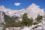
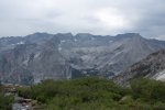
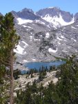
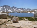
I just returned from a 45 mile backpacking trip that lasted Monday thru Friday. I started at South Lake and headed over Bishop Pass into Dusy Lakes Basin. Headed down to Le Conte Cyn then down the Middle Fork of the Kings River to Palisades Creek. Up Palisades to Mather Pass, down to the South Fork of the Kings and then out over Taboose Pass.
Saw bear, deer, marmots etc. Rained, hailed, lightning and thunder, absolutely stunning weather.
I brought my fly pole and caught fish for dinner along the way. Fishing was great, especially in the creeks.
I need to do more of this, it's good for the soul to get out of the car and walk away.
Sorry for the short TR but really what more is there to say?