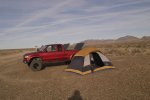
For night one camping midway, you might consider near the intersection of Augustine Pass Road. It has some flat areas, although not real large it worked for my group of eight vehicles. The ground there is covered with small stones visible in the photo below, but an air mattress eliminates that.
When I pre-ran the route in Dec. 2007, I arrived there after dark and setup camp solo. I had an interesting sound and light show courtesy of our military. To the south, in the Chocolate Mtn Gunnery Range, there were sounds of helicopters and machine gun fire, maybe a mile or two away, over the hills. Then I noticed aerial flares slowly falling from the sky periodically. A large turboprop aircraft (probably a C-130) circled overhead and south toward the sounds. This went on for about and hour, off and on. Very cool. The C-130 probably had a visual on me with night vision. I hadn't seen any vehicles in hours so I was the only one around for many miles.
An interesting side trip would be to head north on Augustine Pass Road, to do the Augustine Pass-Chuckwalla Spring Detour. This is described at the end of Gold Road to La Paz There are some tight sections for full size vehicles and it's a little challenging (more technical), but the views are spectacular. The biggest challenge is route finding and following the book. It took us several hours to find our way through and back to the Bradshaw Trail, but it is well worth it if you can spare the time.
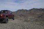
Basically, you head north through the pass over the ridge of the Chuckwalla Mtns. and down a narrow canyon, eventually descending into a wide wash with views to the north to I-10. Then head east into a mining district and view some more recently abandoned mines. Then climbing up through the Chuckwall Canyon to the ridge again and over to the trail at Chuckwalla Well (a former stage stop). There is a lot of history in the area and the views to the north and south from the razorback are superb.
It took us several hours to find our way through and back to the trail, which shortend the trail run for us, but for me, it was the highlight of the trip. If you can't make the whole detour, try going up the ridge line from the south at Chuckwalla Well. That is easily found, as the trail is visible up the ridge from the Bradshaw. I can provide GPS coordinates for part or all to aid in navigation if you are interested.
For those that couldn't make this trip, I will be leading a group over the Bradshaw Trail on the weekend of April 4-5. I will be starting at the same Arco and heading east. I have not explored the Geode Beds, so that may be on the agenda. All are welcome. I will post info as the date gets closer.
Photos attached: Camping at Augustine Pass Rd intersection. And the view looking north from the ridge above Chuckwalla Well.