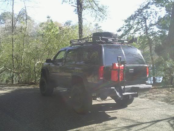
How is your truck set up for an expedition??

kellymoe

Expedition Leader
A GPS is sooooo over rated...

A big X2, nothing beats a good set of topos and the knowledge of how to read them. I know Scott knows already but too many rely on GPS and really miss out on a lot of cool stuff because they are too busy following the route set for them by the GPS.

A big pet peave of mine is when people ask me for the GPS coordinates to a meeting place.
 

xx.xii

Observer
besides adding a crafstman 41'' tool chest on the right side of cab in my yukon to hold tools and auto supllies(exta spark plugs,fuses,elec. tape,duct tape,gas tank repair,sand paper,teflon tape, nuts and bolts, zip ties, duct seal, etc.), have my gas can carrier mounted to the back holding axe and shovel, roof rack holds spare tire and hi lift. i will mount one of my long pelican cases 1700 models(holds rifle as of now,others hold power tools for work and trail) that will hold straps,come alongs,bungee straps, more tapes,flares,etc.,...

im actually savin up to buy a new bumper that is set up as a spare tire carrier and ill just mount my gas can carrier to that so i wont have to have too much trouble lifting up and down to get a spare 37'' spare.lol.,i have slowly been collecting pelican cases,ammo boxes, and back packs for stowing purposes. one blackhawk 3 day assault pack holds about 27 mre's,one oakley back pack is used as my firstaid pack red in color for high visibility and recognition,some maxepedition packs stuffed with various things such as clothes,chem lights, binocs, fuel tabs, stove,flip flops,sandals,boots,etc...nik naks.

i like the idea of using back packs or pelican cases for the ease of being able to disperse amongst fellow riders when either needing to leave vehicle or set up camp away or whatever the situation may come out. try carrying 6 pelican cases as opposed to 6 packs...you would see it proves difficult as compared to possibly wearing two packs on back one on each shoulder, and one in each hand,not to say this is the norm but to say it would be easier to bring what you need a lot quicker( in the case of an accident, roll over,head on collision with another vehicle or object, getting ''stuck in a jam'', etc.) but you sacrifice more protection when using nylon packs as compared to pelican cases.

gps are nice and efficient,but a map spec to the area of travel would be good as well jic gps fails,and if its available.

i would hope to be able to purchase a premier onboard welder, arb fridge, aux water tank, dewalt 26-28 vt lithium ion power tools, 2500 wt power inverter, d-vise for having a bench vise on my two inch receiver, roll cage, hid aux lights,on board air comp with quick disconnects front and back bumper.

i would always recommend carrying some type of firearm for personal protection and maybe hunting, 22 cal rifle,9mm pistol,revolver,shotgun,etc. you might be out in the middle of no where,bad people are all over the world and applies to middle of no where regions.who knows really? just my opinion.

anyways,i guess i wrote a lot lol, haven't been online in a while and haven't been able to do any more mods to the rig due to work and money which seems everyone can relate, love this site great amount of knowledge here.
kon600x600.jpg
 
Last edited:

Desert Dan

Explorer
X3 on the map reading and interpretation.

Some people get so focused on their GPS/Garmins it is funny.

I have seen people that didn't know what valley they were in but could give you the exact GPs coordinates.

Others don't seem to know what turning on a road up a canyon means. I guess they can't read countour lines or look at which way the water flows.
 

Scott Brady

Founder
A GPS is always a secondary means of navigation, but can provide significant improvements in efficiency in areas where topography has little discernible features, or you cannot get higher than the canopy, like in a jungle scenario.

picture-114.jpg
 

michaelgroves

Explorer
A big pet peave of mine is when people ask me for the GPS coordinates to a meeting place.

Why?? If the coordinates are known, it seems an excellent idea to help avoiding misunderstandings!

I agree that a GPS isn't a substitute for other navigational skills, but don't throw the baby away with the bathwater - it's a fantastically useful device. Likewise, it's true that people can get over-involved with their GPS instead of the journey, but that's a personality thing, just as some people get over-involved with their trucks.
 

kellymoe

Expedition Leader
Why?? If the coordinates are known, it seems an excellent idea to help avoiding misunderstandings!

Case in point, I was leading a trip in the Mojave desert for a local club. For meeting point I gave the location Hwy 14 at Jawbone Station 20 miles North of Mojave. Many, many emailed me for GPS coordinates. A few asked how they could find the coordinates after I told them I dont have them but i did give them exact verbal instructions. It's as if people are lost without them and that is a great danger in my opinion. What did people do before GPS? Heck what did people do before cell phones? Dont get me started on cell phones, who are all these people talking to and why?
 
Last edited by a moderator:

X_Trippin

Observer
Why?? If the coordinates are known, it seems an excellent idea to help avoiding misunderstandings!
QUOTE]

Case in point, I was leading a trip in the Mojave desert for a local club. For meeting point I gave the location Hwy 14 at Jawbone Station 20 miles North of Mojave. Many, many emailed me for GPS coordinates. A few asked how they could find the coordinates after I told them I dont have them but i did give them exact verbal instructions. It's as if people are lost without them and that is a great danger in my opinion. What did people do before GPS? Heck what did people do before cell phones? Dont get me started on cell phones, who are all these people talking to and why?


Drive out 14. Stop when you hit Jawbone. It's on the left if your going north from LA.

Maybe it just scares people to not know exactly where they are at or where they are going. I bummed around our local mountains and desert this weekend without looking at a map or GPS. But, I can also look at the sun and know what direction I'm going.
 

James86004

Expedition Leader
Although I can read a map, use a compass, and tell direction from the sun and stars, I sure think of the GPS as a major boon. Too many times I have gotten directions from people who left out an important step (Step 5: at the Y, turn left). Having the coordinates makes it a lot less ambiguous.

Last fall, we were trying to find a specific site in the Gila National Forest in New Mexico. We were following the directions in a guide book, but there was clearly a typo, because it told us to turn right after 14.1 miles. We went 14.1 miles, and there was no right turn for a mile on either side of 14.1. We were in heavy tree cover, so we couldn't see any landmarks. We were trying to figure out how many miles based measuring the map, but the area for the right turn had 3 roads going off to the right in 1/2 mile, and there were enough turns on the road that we were not confident of our map measuring to that accuracy. Also, our map only showed 2 of those roads, and it was impossible to tell which was the new one. Fortunately, after 3 hours we came upon a township & range corner marker, so we were able to figure out exactly where we were and measure from there. A GPS would have saved us those 3 hours.

I have had this sort of thing happen many times (usually in places with lots of tree cover), so I regard the GPS as essential.
 

michaelgroves

Explorer
Having the coordinates makes it a lot less ambiguous.

That's the crux of the matter. I'm confident of my own navigational abilities (and even more so of my wife's) without a GPS, but every seasoned traveller has been in the situation,at some point or other, where they just aren't sure if they're on the right road, or if they're at the meeting place agreed, or whether the correct turn-off is in front or behind them... A GPS and a good map brings peace of mind and lets you concentrate on other aspects of the journey.

Of course, there's nothing wrong with travelling without one, and honing the manual navigational skills. Plus losing your way is often a wonderful part of the adventure. But sometimes not...
 

TeriAnn

Explorer
Agreed. Every time I see pics of your set-up, TeriAnn, I find something new to marvel at.
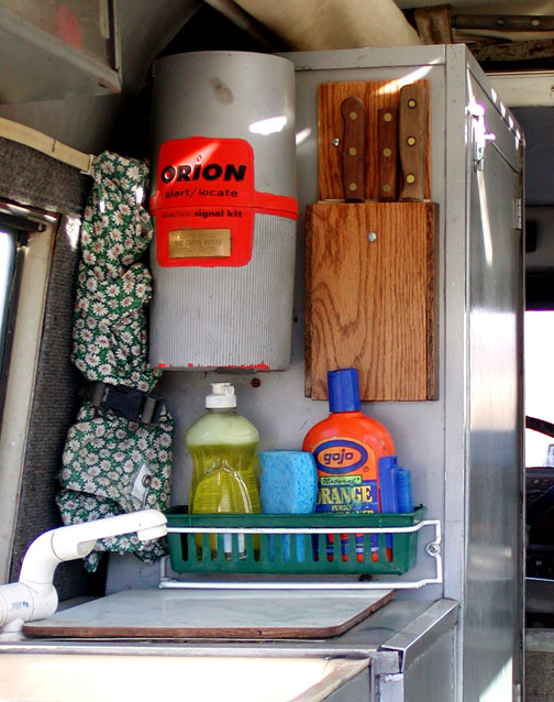
OK Here's a recent interior picture taken in camping mode:

GR_knifeRack.jpg

I'm really proud of the oak knife rack. It took me a couple days to make that. I'm not a wood worker so that was a major project for me.

My Land Rover is what happens then a woman is allowed to nest in the back of her truck without some guy saying things like white daises on the curtains are a little much. Most of the truck upgrades are things that broke in the past that I over fixed because I'm tired of rebuilding my truck on the trail.

And yes, that is an Orion signal kit also in the picture. I read somewhere that if you are stranded and in need of help one should not be shy about letting others know. So if someone is looking for a Land Rover lost in a blizzard look for flares & red smoke. Of course I'll probably be inside toasty warm with a steak on the broiler, mushrooms & onions being grilled, a fresh salad made and a glass of wine to wash it all down with.
 

Overdrive

Adventurer
And, your Land Rover is what happens when a person with a terminal case of wanderlust keeps the same vehicle for 30 years (and counting), which is just awesome!

Correct me if I'm wrong, but I think you told me at the Moab National Rally that you had an estimated 500,000 miles on The Green Rover? Since I have not had the foresight to keep any one vehicle that long, it really intrigues me to see how a vehicle morphs into something that gets closer to perfection with a long ownership period...a vehicle that was built through trial and error and camping trips too numerous to mention...not simply purchased that way.
 
Last edited:

R_Lefebvre

Expedition Leader
My disdain for paper maps, etc. largely stems from people's seeming inability to give proper directions. I don't trust other people's directions, because they're usually bad. Also, some of the people in the west criticising those in the east for using GPS... you don't have to be in a "jungle" to not be able to see the lay of the land. Any forest will do that to you. Normally I'm lucky if I can see 100 feet in any one direction. Climbing the nearest peak to try and figure out where you are could be a day long adventure in and of itself.
 

Forum statistics

Threads
188,183
Messages
2,903,509
Members
229,665
Latest member
SANelson
Top